All Activity
- Past hour
-
Shift that north 100 miles. Probably the real solution
-

December 2025 regional war/obs/disco thread
TauntonBlizzard2013 replied to Torch Tiger's topic in New England
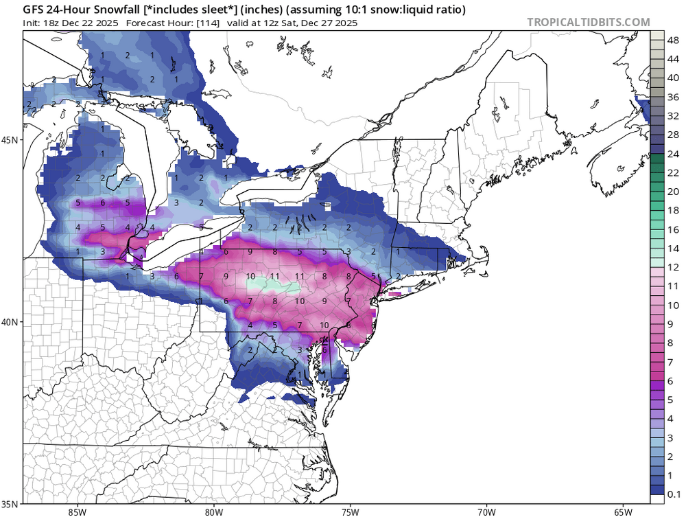
NYC having 10x as much snow as Boston on the year after Saturday? Holiday cheer for all -
Gfs 850's on top and Nam below. Notice wind direction too.
.thumb.png.73d41b411d1a6c482ee6a0765e7e78b6.png)
.thumb.png.0e5b8dc251e6f994aa8318193f4ac8ee.png)
-
GEFS should be a bit better I think, stronger high
-
GFS would at least give the ski resorts opportunities next week to make snow with favorable upslope conditions too (blah blah OP run, I know). Good timing given Christmas and New Year crowds. Given where some thought we were heading for end of the month, it doesn't seem like we're going to be staring at days and days of warm temps.
-
It's 100% a colder look. There's also more confluence. That 546 line shifting 50 miles south could be the difference between sleet/zr/rain and sleet/snow in DC.
-
 Where’s our Christmas torch? Lol
 -
Probably the way models are trending, it's becoming a question of whether the milder air ever makes it past central NJ but I think temps will spike at around 45F for a few hours late Christmas Day, then slide down into high 20s setting up a solid wall of icy resistance when the Friday wave drops southeast, could lead to a much heavier snowfall than forecasts are currently saying (can't say record because it's 78 years after 12-26-1947). A few days ago it was looking like a very mild two days 24th-25th and now it's looking more like a couple of hours of slight warming. Encouraging when the models bust on the warm side.
-

Mid to long range discussion- 2025
Leesville Wx Hawk replied to wncsnow's topic in Southeastern States
18z GFS even further west with trough and is responding to the building negative NAO that you mentioned. . -
18z Gfs has the 546 height line through northern Baltimore City while the Nam has it just south of DCA. IF the Nam is closer to correct with the cold air draining further south, that's enough to make a difference for some.
-

December 2025 regional war/obs/disco thread
Damage In Tolland replied to Torch Tiger's topic in New England
Scooter so embarrassed he hasn’t posted all day . Just refreshing the board each set of runs and couldn’t control himself from weenieing my last post -

December 2025 Short/Medium Range Forecast Thread
Matthew70 replied to John1122's topic in Tennessee Valley
I guess we don’t need the wooly warm connection this winter! Lol. I did hear thunder a few days ago so there is that connection! Yep a bucket list is checked off. I met the GOAT! -

2025-2026 ENSO
Jersey Andrew replied to 40/70 Benchmark's topic in Weather Forecasting and Discussion
Stunning changes to say the least. What is causing such large discrepancies? -
December 2025 regional war/obs/disco thread
TauntonBlizzard2013 replied to Torch Tiger's topic in New England
I mentioned this to Ray this morning. The angle blows for most of New England. So the storm could literally be close by and miss most of us -
December 2025 Short/Medium Range Forecast Thread
Matthew70 replied to John1122's topic in Tennessee Valley
Being an Alabama fan. Good gracious. My wife & kids told me not to come home!!! lol. They are kicking me out for not bringing them to meet him. -
December 2025 regional war/obs/disco thread
TauntonBlizzard2013 replied to Torch Tiger's topic in New England
Well, after flopping around for days, the models have suddenly shown remarkable consistency now that the consensus is largely a whiff for New England -
GFS keeps the temperature's below freezing even in the city for the entire event!
-

Winter cancelled/uncancelled banter 25/26
NorthShoreWx replied to Rjay's topic in New York City Metro
Russian drone -
December 2025 regional war/obs/disco thread
TauntonBlizzard2013 replied to Torch Tiger's topic in New England
Yeah, being on the outside looking in right now is kind of scary. If this goes more south at all, we’re cooked -
Yeah it doesn’t happen too often but this is admittedly a weird setup. We want to see ensembles tighten before really getting a good handle. The mean still has decent precip up into NNE so there’s a lot to spread.
-

December 2025 regional war/obs/disco thread
Sey-Mour Snow replied to Torch Tiger's topic in New England
Crazy the Friday storm is in NAM range for 6z run tonight . Glad the gfs is the southern outlier . But 12 EPS does look kind of gfs like .. let’s get this north to include more of New England -

December 2025 regional war/obs/disco thread
WxWatcher007 replied to Torch Tiger's topic in New England
I don't think the Euro is king anymore, so I take it with the same grain of salt as the GFS, etc. -
I don’t think Boxing Day will be for us but I do like seeing the big warmth not materialize.
-
Just saw a small meteorite burn up over Coram/Selden at a pretty low altitude, I saw the smoke and everything. Came in like a missile. Not far off from the flight path into ISP.
-
December 2025 regional war/obs/disco thread
Damage In Tolland replied to Torch Tiger's topic in New England
When doesn’t it with winter storms? This is like old days GFS that was always south and you could predict exactly what and when it would come back north, That’s in fact how we started the north trend term that the mid Atlantic still hates us for .


.png.fb1df4e5a1a77781bc1e3a407b451fdb.png)
.png.7dce8cbb3ad021449a9a59141f796aa9.png)


