All Activity
- Past hour
-
Most everyone cashed in, but still some losers and winners.
-

2026-2027 Super El Nino
LakePaste25 replied to Stormchaserchuck1's topic in Weather Forecasting and Discussion
-
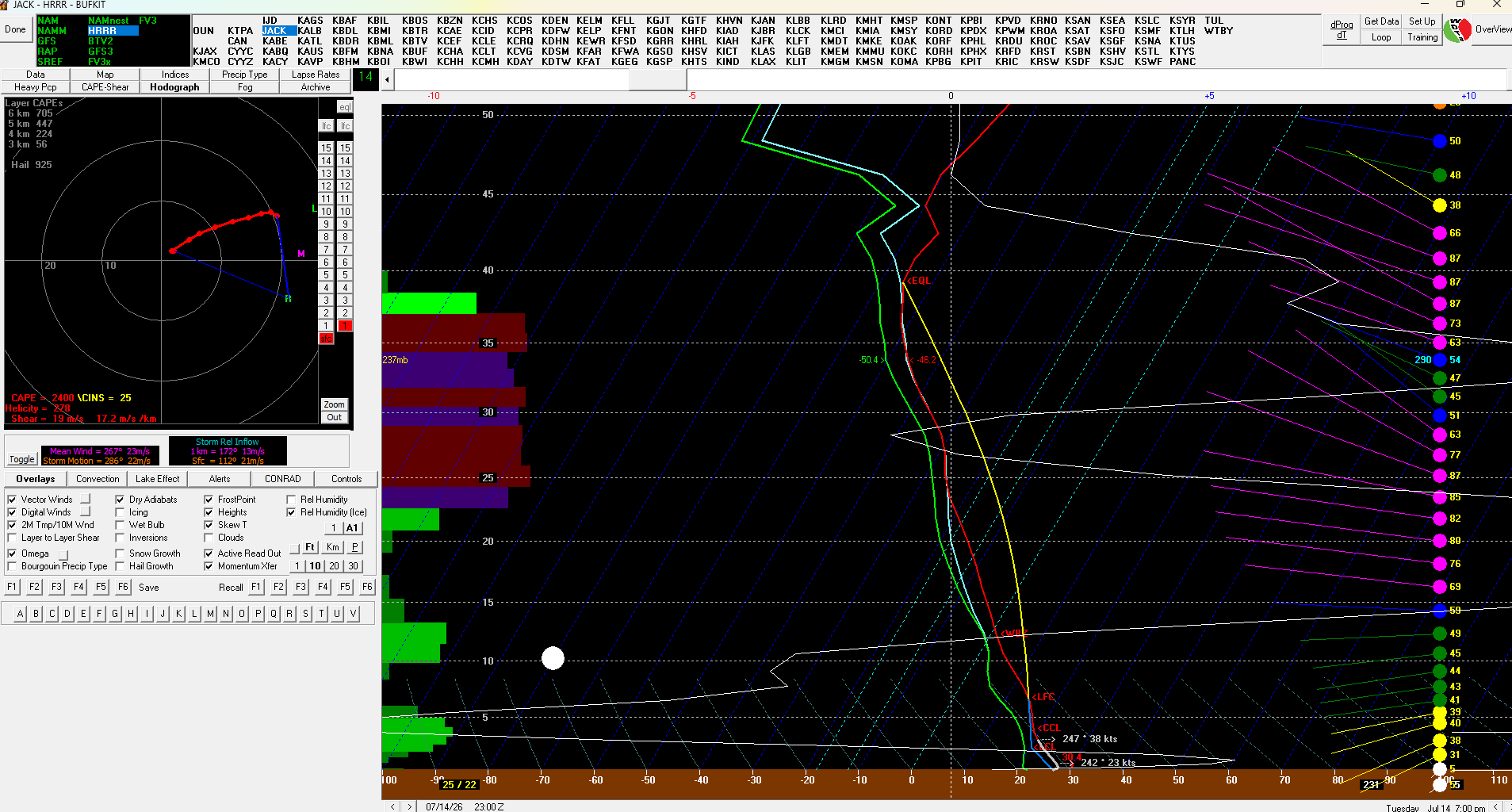
 9z HRRR for JACK Probably would like to see a bit more curvature in the 0-1km layer for true concern for a strong tornado, but those sfc winds end up more 200° you're going to ramp that up quickly. But this is a significant amount of CAPE up to the EL and that mlvl shear. You get a mature supercell moving into this environment and you're probably looking at a spaceship structure. Pretty good inflow into the environment too.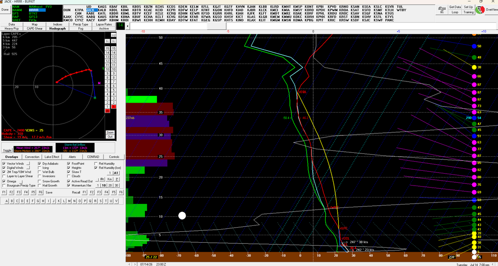
-
 Methuen borders Lawrence I can always smell smoke where I live in Methuen....
 -
2026-2027 Super El Nino
LakePaste25 replied to Stormchaserchuck1's topic in Weather Forecasting and Discussion
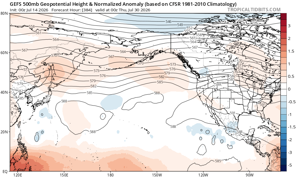
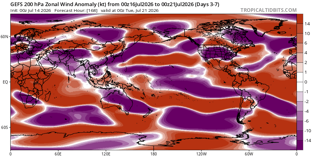
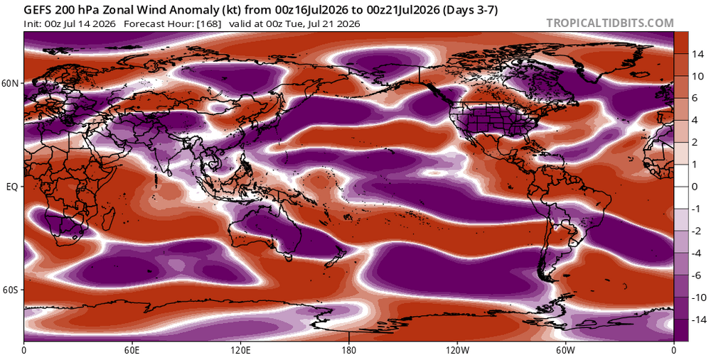
Definitely a lack of +U out there in the N pac. Wonder if this changes in the Fall.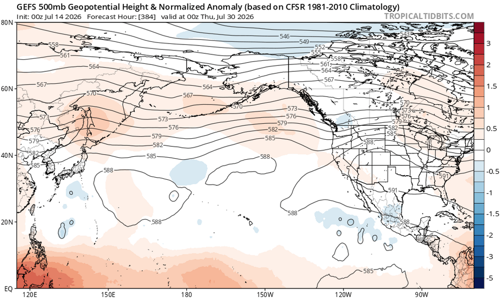
-
 I can smell it outside right now.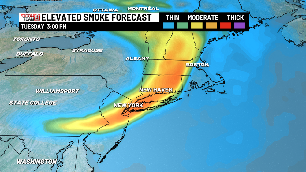
-
 This is interesting: Some of the high-res guidance is beginning to come around to the idea of showing convective development trailing back westward along a cold front with a weakening capping inversion into central VT/NH as soon as early overnight; but the timing and coverage of this activity still is pretty scattershot across the high-res suite. This could ultimately end up being a nowcast situation, but given this trend I couldn`t really justify NBM`s nil PoPs. Opted for up to 30% PoP along the MA/NH/VT border between 4-7 AM Wed, then slowly sagging southward through the day. If any storms develop, they would likely become strong to potentially severe quickly given the degree of instability aloft and pretty strong NW mid-level winds, with frequent lightning, hail and strong straight line winds all possible, potentially early in the day as well. Low confidence but potentially higher impact if storms can materialize.
 -
 Smoke
Smoke -
Yay Zone Forecast Product National Weather Service Baltimore MD/Washington DC 456 AM EDT Tue Jul 14 2026 DCZ001-141200- District of Columbia- Including the cities of Adams Morgan and Washington 456 AM EDT Tue Jul 14 2026 .REST OF THE OVERNIGHT...Clear. Lows in the mid 60s. Light and variable winds. .TODAY...Sunny. Highs in the lower 90s. Southwest winds around 5 mph. .TONIGHT...Clear. Lows in the mid 70s. Southwest winds around 5 mph. .WEDNESDAY...Sunny, hot with highs around 101. West winds 5 to 10 mph. .WEDNESDAY NIGHT...Partly cloudy in the evening, then clearing. Lows in the upper 70s. Northwest winds 5 to 10 mph. .THURSDAY...Mostly sunny. Hot with highs around 100.
-
 Debris clouds
 -

2026-2027 Super El Nino
bluewave replied to Stormchaserchuck1's topic in Weather Forecasting and Discussion
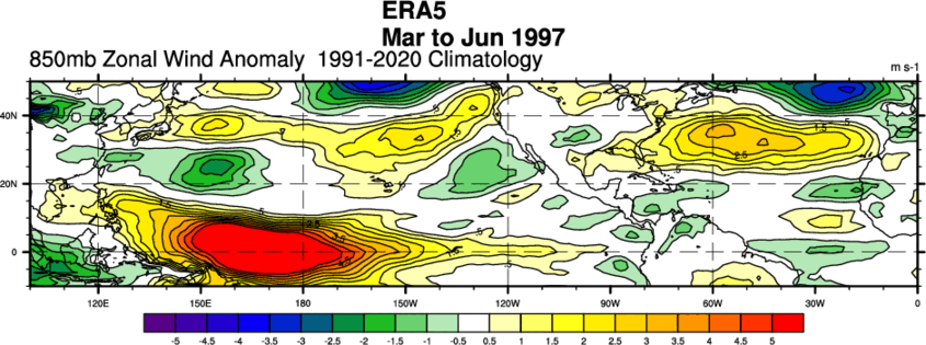
In the old days with super El Niños, the strong low level westerlies would extend north from the tropics into the mid-latitudes like in 1997. During the 2020s, the subtropical or mid-latitude ridges have grown to record levels. So the westerly flow is much weaker with the high pressure dominating. The warm pool from Japan to north of Hawaii is allowed to continue leading to the persistent -PDO. This prevents the strong +PDO response that was typical in 1997 and 2015. This is also why we have see strong to record heat domes across the CONUS since May from time to time instead of the cooler typical El Niño pattern this time of year.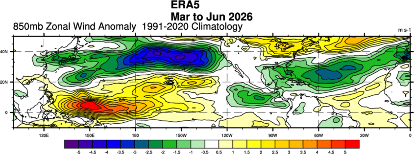
-

2026-2027 Super El Nino
PhiEaglesfan712 replied to Stormchaserchuck1's topic in Weather Forecasting and Discussion
As I said, I'm going to wait until the fall before taking this seriously. If the strong winter signal is still there in September/October, then you know it's going to be a cold and snowy winter. 2009-10 was the last time a strong winter signal held in the fall during a developing strong el nino. Contrast that to 2015-16 and 2023-24, when there was no strong winter signal in the fall months. -

Central PA Summer 2026 Discussion/Obs Thread
mahantango#1 replied to Voyager's topic in Upstate New York/Pennsylvania
- Today
-
 Humans survived the Cubs and the Red Sox both winning the Series. We will be ok (unless Cleveland wins it)
 -

Central PA Summer 2026 Discussion/Obs Thread
Mount Joy Snowman replied to Voyager's topic in Upstate New York/Pennsylvania
67 when I left the house. Got a mow in yesterday before the heat hits, first one in like two weeks. -
Nice MCS coming into Maine and NNH to start the morning.
-
Central PA Summer 2026 Discussion/Obs Thread
mahantango#1 replied to Voyager's topic in Upstate New York/Pennsylvania
WGAL News Channel 8 Susquehanna Valley, Pa. stonpSorde383mc43fttcm5lcaf7c5i810404f8021tli2243icg6i52h16a · The U.S. has approved plans for an experimental satellite carrying a massive mirror, designed to test if “sunlight on demand” is possible by reflecting sunlight onto targeted areas on Earth. The project has drawn sharp criticism from astronomers and environmental scientists.https://www.wgal.com/article/fcc-approves-space-mirror-reflect-orbital/71919795?fbclid=IwY2xjawTC8E9leHRuA2FlbQIxMABicmlkETEyWUk1bkFnTUI4eUI3ZkJPc3J0YwZhcHBfaWQQMjIyMDM5MTc4ODIwMDg5MgABHvIX-pxjYfi4pQg_27rHtfuYb6YHFyPyH5-nyhvboPdnOeVPybIPBTyR54pr_aem_1hzWC-lEWX55Ae_f03FxTA -
 We wont get a heatwave here but still sucks Today Sunny and hot, with a high near 91. West wind 6 to 15 mph, with gusts as high as 26 mph. Tonight Partly cloudy, with a low around 73. West wind around 10 mph, with gusts as high as 24 mph. Wednesday A chance of showers and thunderstorms, mainly before noon. Partly sunny, with a high near 89. Northwest wind 9 to 13 mph, with gusts as high as 25 mph. Chance of precipitation is 30%. Wednesday Night Partly cloudy, with a low around 64. Northwest wind around 5 mph becoming calm in the evening. Thursday Sunny, with a high near 82. Light west wind increasing to 9 to 14 mph in the morning. Winds could gust as high as 28 mph.
 -
Central PA Summer 2026 Discussion/Obs Thread
mahantango#1 replied to Voyager's topic in Upstate New York/Pennsylvania
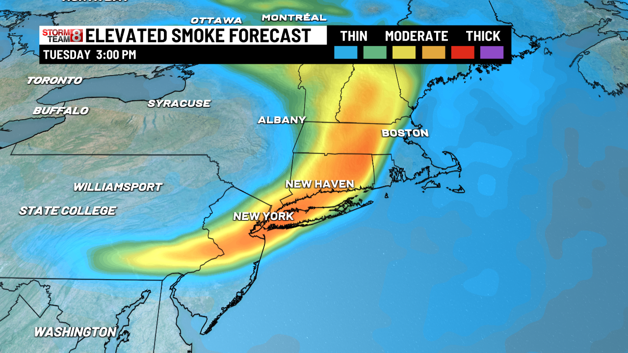
The latest information has a band of thick smoke moving into our area Wednesday afternoon. If this pans out, I wouldn't be surprised to see Air Quality Alerts issued. People with respiratory problems will want to watch this closely. www.fox56.com/weather -
Do tornadoes crossing the border need a passport?
-
AQI numbers are still in the mid 60s, like yesterday morning, but it's different. It's like the air is "heavier".
-
 The 1821 outbreak is my Roman Empire.
 -
May be two areas today for some strong tornado potential, far northern New Hampshire towards the Canadian border and northern Maine. Have to see what sfc flow is like
-
As annoying as a miss south major winter storm.