All Activity
- Past hour
-

November 2025 general discussions and probable topic derailings ...
dendrite replied to Typhoon Tip's topic in New England
Thu but it only goes through yesterday. We're well below normal precip this month even with last night's rain. -
Can we just score one early for once that would be amazing.
-

December 2025 regional war/obs/disco thread
HoarfrostHubb replied to Torch Tiger's topic in New England
It’s got a heartbeat at least
-

December 2025 regional war/obs/disco thread
Damage In Tolland replied to Torch Tiger's topic in New England
All good news . Hopefully everyone cashed in on Tuesday and we don’t lose it. For Wolfie.. snow threats and as of now it’s not slipping away -

Nov 28-30th Post Turkey Day Wintry Potential
A-L-E-K replied to Chicago Storm's topic in Lakes/Ohio Valley
that was such a sick event for you -
Absolutely. And wrt the 850's, the 6z now has that classic drainage down the eastern side of the Apps that was missing at 0z.

-

November 2025 general discussions and probable topic derailings ...
Lava Rock replied to Typhoon Tip's topic in New England
0.59" overnight. when's the next drought monitor update? -

December 2025 regional war/obs/disco thread
WinterWolf replied to Torch Tiger's topic in New England
Selective memory isn’t good either…

-

Nov 28-30th Post Turkey Day Wintry Potential
King James replied to Chicago Storm's topic in Lakes/Ohio Valley
I’m about a foot of snow ahead of most of you so feels like I have to just watch this one and hope someone cashes in. Even 4 inches for me would be a steal. I’ll go 3.1 inches final call. -
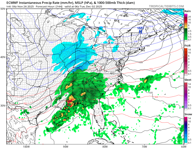
Yeah the main show looks mostly on Tuesday as presently modeled. But this is kind of a delicate look with the timing of the southern energy. We’re gonna want this to hold serve for a couple more days before confidence increases a lot. The good news is even if that threat craps out, it looks good for additional threats behind it. Overnight longer range guidance has become a little more aggressive in retrograding the Scandinavian ridging into northern Greenland which in conjunction with a bit more amped WPO ridge, is producing a colder look into mid-December.
-
Winter 2025-26 Medium/Long Range Discussion
A-L-E-K replied to michsnowfreak's topic in Lakes/Ohio Valley
would be nice to get the high ratio duster mid week to trend favorably -

December 2025 regional war/obs/disco thread
moneypitmike replied to Torch Tiger's topic in New England
I told my wife that we'll never have snow at our new Pit1. It would be funny if she's calling me a liar in the first week of December. Bring that up to Pit2. -
6z euro def better than 0z thru 144. So that’s something.
-
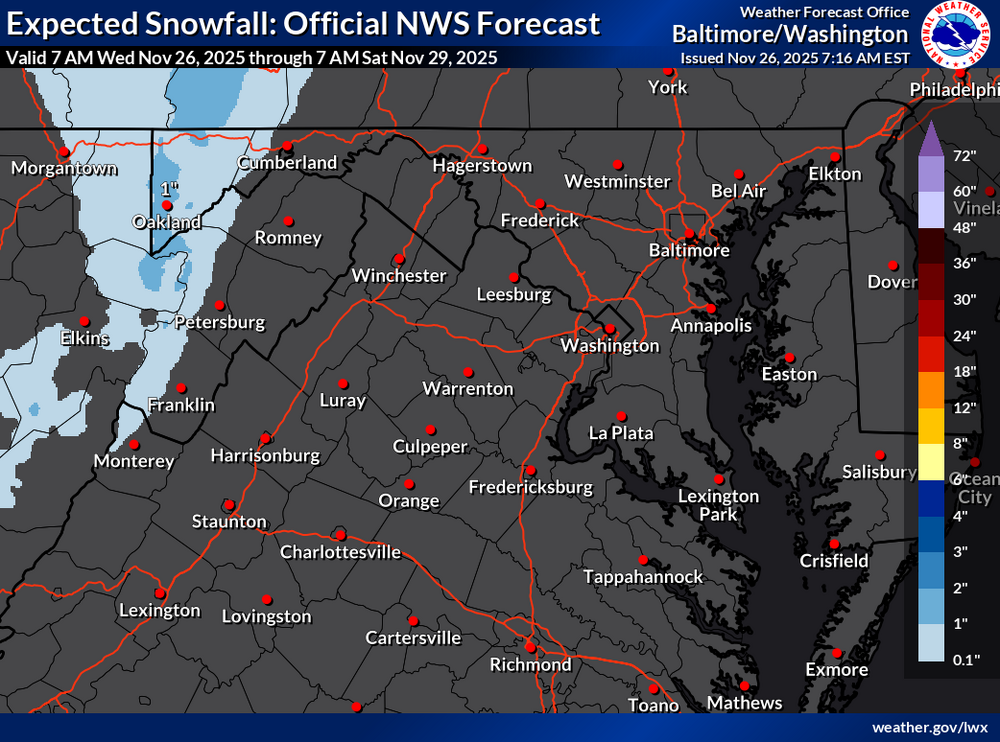
Overnight high of 51, currently 48 degrees. Latest from LWX for snow shower chances through Saturday.
-
@forkyfork Thoughts on next week’s storm?
-
Forecast for WXW2 keeps beefing up. Now 5” expected with the Thanksgiving storm. Need that a month from now. We’re doing Thanksgiving in CT and Christmas in SLK.
-
December 2025 regional war/obs/disco thread
Damage In Tolland replied to Torch Tiger's topic in New England
Seems like it’s moved towards more of Tuesday storm winding down by Wednesday morning now -
 54.2° here at WXW1. 38.8° at WXW2, warmest morning of the month. We torch before winter sweeps in. Thankfully short lived.
 -
Probably our warmest day of the week today with several spots approaching 60°.
-
There’s some decent energy rounding the base of the longwave trough after it moves east a bit so we get this brief window for a more coastal system. I think most subsequent threats beyond that are likely to be SWFEs. Previously for 12/2-12/3, the southern stream energy was hanging back in the southwest while northern stream moved over us…then, when the southern stream ejected a day or two later (say getting us by 12/5ish…which is why we were saying post-12/3 looked decent), it would push a SWFE up into the cold that was established ahead of it by the northern stream…but it’s not evolving like that now…instead, they are almost moving together so we get this threat to potentially materialize on 12/2…southern stream still lags a bit which is a good thing because it allows the baroclinic zone to set up offshore. But it’s still close enough that it can produce a coastal on some of these runs.
-
December 2025 regional war/obs/disco thread
Damage In Tolland replied to Torch Tiger's topic in New England
Hopefully it’s paste and not powder -
December 2025 regional war/obs/disco thread
WinterWolf replied to Torch Tiger's topic in New England
Lmao… -
3.1” at MSP. Still blowing and snowing
-
December 2025 regional war/obs/disco thread
Damage In Tolland replied to Torch Tiger's topic in New England
That’s not what I posted if you paid attention. I said we would see several snow chances . But the great promised month was slipping away. Selective reading is not good -
0.12" for the date, getting me to 1.27" for the month. A warm night, hanging in upper 40's, currently 49.5/48.3 at 7:45 with VERY dense fog.


