All Activity
- Past hour
-
As long as you bring a snow shovel with you as well...
-

January 2026 Medium/Long Range Discussion
Scarlet Pimpernel replied to snowfan's topic in Mid Atlantic
Better than smoking cirrus a'la the Euro. A lot better. -
.
-
No
-

Possible coastal storm centered on Feb 1 2026.
DavisStraight replied to Typhoon Tip's topic in New England
It's coming, it needs a little time. -

The “I bring the mojo” Jan 30-Feb 1 potential winter storm
scottk replied to lilj4425's topic in Southeastern States
In Florence, SC (NE SC) the locals are just saying a chance of light snow. What exactly do I need to pull for to get better than that? Lol -
It'll be me, bf and the umbrella
-
What’s causing the minima in McDowell and Rutherford counties on these GFS runs?
-

The “I bring the mojo” Jan 30-Feb 1 potential winter storm
BornAgain13 replied to lilj4425's topic in Southeastern States
18z AIGFS is a big hit to! Ratios would be high with this precip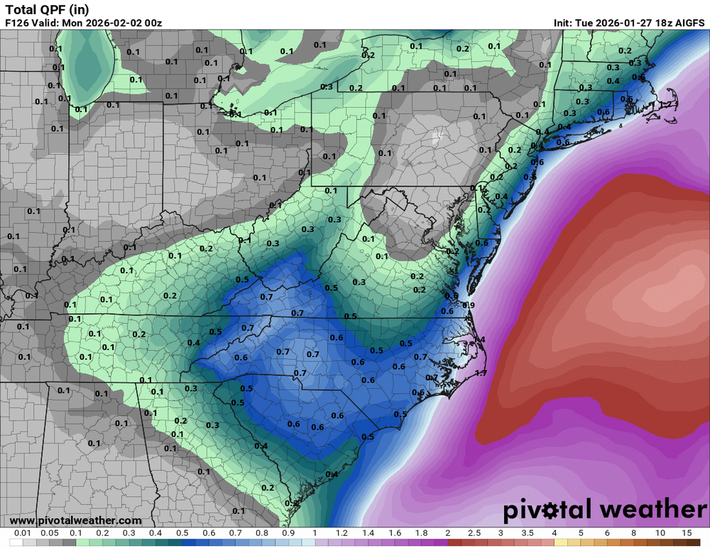
-
I expect zero confirmation from the Euro. AI in an hour or so will tell the tale
-

Possible coastal storm centered on Feb 1 2026.
Henry's Weather replied to Typhoon Tip's topic in New England
Gun to my head, I think this hits us. I think majority on the forum agree (not that it actually matters). We’ve seen too many of these shift NW incrementally -
Don - as you know, the NBM is time lagged and in the last 24 hours there were some bigger runs of models that show little to no snow now, like the Euro/AIFS. I don't know how far back they go, though, but it sure looks like a blend of all the models most look at wouldn't be showing more than an inch or two for 95 vs. 6" in the NBM. I recall last week the NBM was consistently showing 12-18" for our whole region through 48 hours before the storm (when most models were showing less and decreasing), which informed the NWS-Philly's 12-18" forecasts at that point - but then the NBM dropped a decent amount over the next few runs, such that the NWS stepped down several times from 12-18" to the 7-11" amounts they had for most right before the storm. It's hard for me to imagine, right now what is causing the NBM to currently be so high. I'm not saying the models can't shift back in such a highly volatile setup, though, especially as we saw a shift north of about 150-200 miles from about Day 5 to Day 3 last week (and it kept going north).
-

January 2026 Medium/Long Range Discussion
midatlanticweather replied to snowfan's topic in Mid Atlantic
There were looks that reminded me of 2016 but now that snow map makes me think of the dreaded 2018 miss! - It is the GFS anyways.. -

January 2026 Medium/Long Range Discussion
NorthArlington101 replied to snowfan's topic in Mid Atlantic
Really need the EURO to show a storm soon but otherwise agree with the larger point -
Congrats southern Mid Alantic and Coastal SNE on the gfs.
-
I have a big house with plenty of extra room...you're welcome to come down and get snowed in for a week if it verifies.
-
I’ll take care of the bunnies in Bob Chills old yard.
-
Funny, I was gonna suggest the thread be extended until at least 1/31. Down here in the lower lakes the cold looks to peak around Fri/Sat. Forecast is showing multiple days of lows at double digits below zero. That is impressive down here in the banana belt. Also a ton of daily records are in play for CLE's CWA. Most records for 1/30 and 1/31 are pretty low hanging fruit (example CLE -4 on 1/30, -5 on 1/31) so some of these could be clobbered by 10 degrees or more.
-
Boston and Cape Cod do well on gfs
-
Arctic air now covers the region. Highs will be mainly in the lower 20s through Friday. One or more days could see highs in the teens. The last winter with more than one high in the teens was Winter 2018-19 when there were two such days. Moreover, New York City has the potential to see the temperature dip into the single digits for lows on or more days during this period. Some snow flurries or snow showers are possible Thursday night into Friday morning. Additional snow is possible on Sunday. However, there remains significant uncertainty about the location of the storm's development and its track. A large storm would be historic. For reference, New York City has seen just one 10" or above snowstorm one week or less following a 10" or above snowstorm: February 3-4, 1926 (10.4") and February 9-10, 1926 (12.4"). The shortest interval between 10" or above daily snowfalls is 14 days: March 2, 1896 (10.0") and March 16, 1896 (12.0"). Records go back to 1869. Overall, January 20th-February 3rd will likely be the coldest and perhaps snowiest two-week period this winter. The forecast WPO-/EPO-/AO-/PNA+ pattern is typically the coldest pattern in January and among the coldest during the first half of February. A persistently positive PNA will have above climatological risk of moderate or significant snowfalls. For perspective, the coldest two-week period this winter prior to January 20th was January 3-16, 2026 and January 4-17, 2026 with a mean temperature of 30.3°. The snowiest two-week period was December 14-27, 2025 when 7.2" of snow fell. Already, snowfall since January 20th has surpassed that figure. The ENSO Region 1+2 anomaly was -0.3°C and the Region 3.4 anomaly was -0.7°C for the week centered around January 14. For the past six weeks, the ENSO Region 1+2 anomaly has averaged -0.48°C and the ENSO Region 3.4 anomaly has averaged -0.68°C. La Niña conditions will likely continue into at least late winter. The SOI was -2.82 today. The preliminary Arctic Oscillation (AO) was -4.601 today. That is the lowest AO value since February 16, 2025 when the AO was -4.772. Based on sensitivity analysis applied to the latest guidance, there is an implied near 100% probability that New York City will have a cooler than normal January (1991-2020 normal). January will likely finish with a mean temperature near 30.2° (3.5° below normal). Supplemental Information: The projected mean would be 2.4° below the 1981-2010 normal monthly value.
-
Yeah agreed. Looked like a weird double low at first too-might be some convective feedback?
-

The “I bring the mojo” Jan 30-Feb 1 potential winter storm
KrummWx replied to lilj4425's topic in Southeastern States
PLEASE EURO I AM BEEGING YOU!! Cause it's the way i'll give up winter 3 years in a row for 30" lmao -
I was thinking the same...
-

Pittsburgh/Western PA WINTER ‘25/‘26
colonel717 replied to Burghblizz's topic in Upstate New York/Pennsylvania
Yes. Thanks. -
26" in Richmond


