All Activity
- Past hour
-

2025-2026 ENSO
TheClimateChanger replied to 40/70 Benchmark's topic in Weather Forecasting and Discussion
Looks like the "high water mark" for the cold, so to speak. With upcoming pattern change, final December numbers should be rather ho-hum. -

December 2025 regional war/obs/disco thread
HoarfrostHubb replied to Torch Tiger's topic in New England
H Sapiens almost didn't make it. A lot of money was riding on Neanderthal for a while... -
That trough position on the Canadian coast is usual not good here. We’ll need the blocking for sure or else the CONUS Chinook reaches here. FWIW AI Ensembles looked better vs EPS.
-

December 2025 regional war/obs/disco thread
WinterWolf replied to Torch Tiger's topic in New England
Go with Ai…they had the general idea right with this last one…from 8 plus days out. -
I don't even have an account on there.
-
Is winter over ?
-

December 2025 regional war/obs/disco thread
Sey-Mour Snow replied to Torch Tiger's topic in New England
-NAO to the rescue or does it link with a SE ridge? Surface warm anomalies still in the Central US.. Generally looks seasonable with average precip during the holiday week, will need luck on our side though I think -
Big storm not happening but it could still snow. Lots of our small to moderate snows you look at the h5 and think how the hell did it snow. When the h5 looks great alot of times ground truth isn't
-
The SouthernWX forum has devolved into a war between warm weather trollers and the rest of the board lmao.
-

December 2025 regional war/obs/disco thread
Typhoon Tip replied to Torch Tiger's topic in New England
late 25th thru mid 27th is an icing pattern. didn't appear y'all mentioned it? If not, that's a stalled polar boundary with duration over running. 1020 +PP situated N of the boundary pushing E while gaining some as it goes + climo = ice event written all over it. Like Will said, ...talk to us when we're within a week. Tru. But, the idea of some sort of a mixy potentials in that time frame is still there in principle.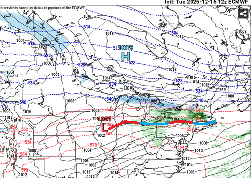
-
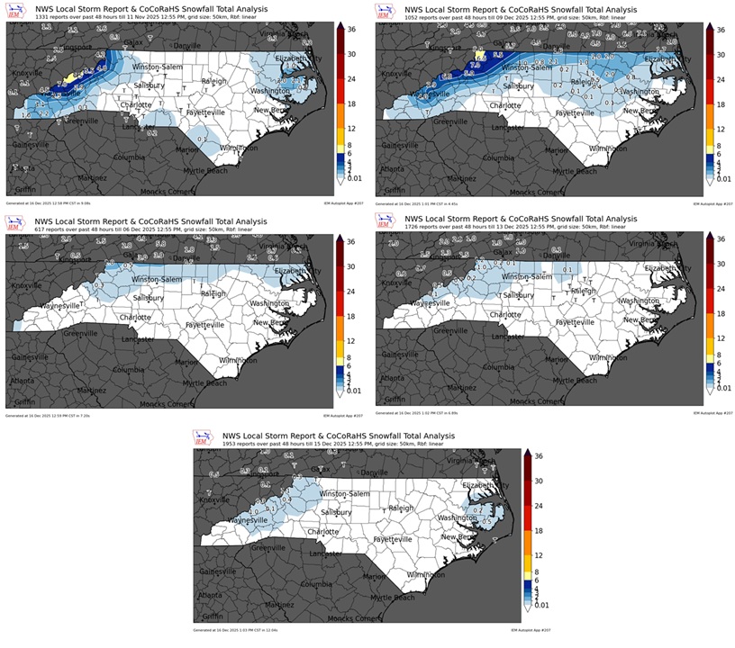
There are multiple areas they list as having .1 that is not accurate though. Most of us foothills folks can tell you that. Regardless, places other than TN border areas and higher elevations have not seen a winter storm in NC this season.
-
Measurable snow is considered .1" or more. Looking at the IEM maps, it appears most of the state has seen at least .1".
-

December 2025 Short/Medium Range Forecast Thread
Daniel Boone replied to John1122's topic in Tennessee Valley
That's the evolution of getting that pesky GOA Low moved. Force that sucker South and West . The Central Ridge gets forced back West from the classic blocking that looks to be setting up..if that 50-50 is real, that'll be the real deal blocking Pattern. -
EPS isn’t pretty either. I mean something eventually has to go right?
-
I would say its generous to say 50% of NC has seen "measurable snow". 80% of those measurable snow areas have seen 1 inch or less. I guess snow falling from the sky without accumulating is considered measurable nowadays.
-
If there was a concern they wouldn’t be attempting it. They’ll have that ice surface plenty cold.
-
Those maps are a bit more generous than the IEM maps shown below; regardless, most of NC has seen measurable snow.
-
I mean it was advertised to be a long shot. Even in New York.
-
Especially if the RNA is closer to the west coast and -2 or less. Would not happen in a +PNA.
-

December 2025 regional war/obs/disco thread
weatherwiz replied to Torch Tiger's topic in New England
I'm sure they will have a top notch cooling system that is going to be cranking (can't even imagine the cost) but I have to think there will be some issues with the ice. -
That map is not even close to reality for almost everyone South of I40. Some areas east of Charlotte got a dusting but that's it.
-
It shows you how a 500 mile difference in feature placement changes everything. The first 2 weeks of December 2010 you can take all those features and shift them 500 miles west and that was basically the pattern. We did not get any big or notable snows though but we were very cold.
-
The ice should be fine. lol
-
I told my dad that literally a few hours ago. Its hard to see what can change up the new base state and the subtropical jet is straight up dead.
-
(002).thumb.png.6e3d9d46bca5fe41aab7a74871dd8af8.png)
E PA/NJ/DE Winter 2025-26 Obs/Discussion
ChescoWx replied to LVblizzard's topic in Philadelphia Region
True! I did not really catch that but indeed!!


