All Activity
- Past hour
-
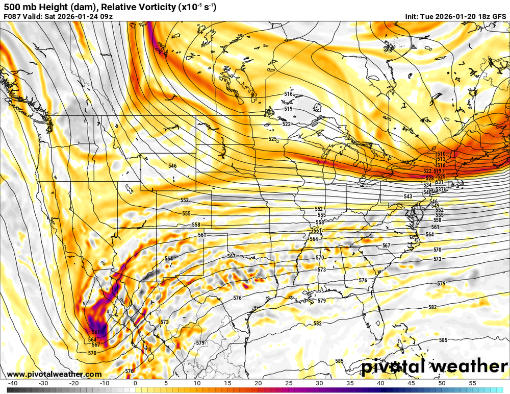
GFS managed to clear the main failure scenario of keeping the SW too far back. Now we get to see how it handles the interaction with the open wave and NS which will be key in determining who gets the major snowstorm.
-
The window is currently very narrow now. The UKIE is the northern most, the GFS, still the southern most, even with this 18z run.
-

MO/KS/AR/OK 2025-2026 Winter Discussion
StormChazer replied to stormdragonwx's topic in Central/Western States
18Z upper air not closing off like it was in earlier runs. This run should yeild higher snowfall amounts more northward like the Euro if everything thing else goes normal. -

January 25/26 Jimbo Back Surgery Storm
Brick Tamland replied to Jimbo!'s topic in Southeastern States
GFS staying all snow so far from Wake north. -
Being stuck in the teens certainly helps.
-
This looks soooo much better. Bring it home!
-

Possible Record Breaking Cold + Snow Sunday 1/25 - Tuesday 1/27
NJwx85 replied to TriPol's topic in New York City Metro
She’s about to go boom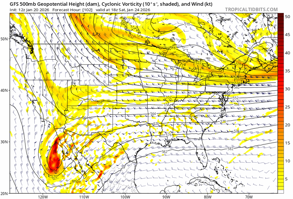
-
 the low is ur right but the precip is a bit sharper and that's south. Good thing is the low is north and stronger that's what we need. sorry about that
 -

January 25/26 Jimbo Back Surgery Storm
franklin NCwx replied to Jimbo!'s topic in Southeastern States
Gfs will be another good run for NC -

January 25/26 Jimbo Back Surgery Storm
Maggie Valley Steve replied to Jimbo!'s topic in Southeastern States
We're going to get Winter RECON sampling the upper low ENE of Hawaii tomorrow with additional Atmospheric River sampling over the Eastern Pacific for the moisture headed our way. -
That could end up with a G… or an F… downstream if the gfs doesn’t f this up.
-
We're all going to slide off the cliff as it'll be covered in ice
-

Possible Record Breaking Cold + Snow Sunday 1/25 - Tuesday 1/27
SACRUS replied to TriPol's topic in New York City Metro
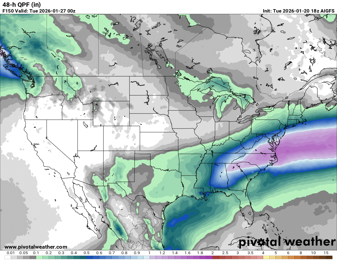
1/20 18Z Total QPF ICON: (120H) in line with 12z GFS: GFS AID: -
Possible Record Breaking Cold + Snow Sunday 1/25 - Tuesday 1/27
NJwx85 replied to TriPol's topic in New York City Metro
It’s already beginning to interact at 06z Saturday. -
Like I said in my yesterday analysis we just need that first phase out west to get the SW moving east and were golden for a major snowstorm somewhere over the east coast. Speaking of which the GFS will be coming back to the fold after its 12z adventures
-
January 25/26 Jimbo Back Surgery Storm
franklin NCwx replied to Jimbo!'s topic in Southeastern States
Gfs AI would be a lot of snow to sleet for NC -
Strength of the cold air, for one thing.
-
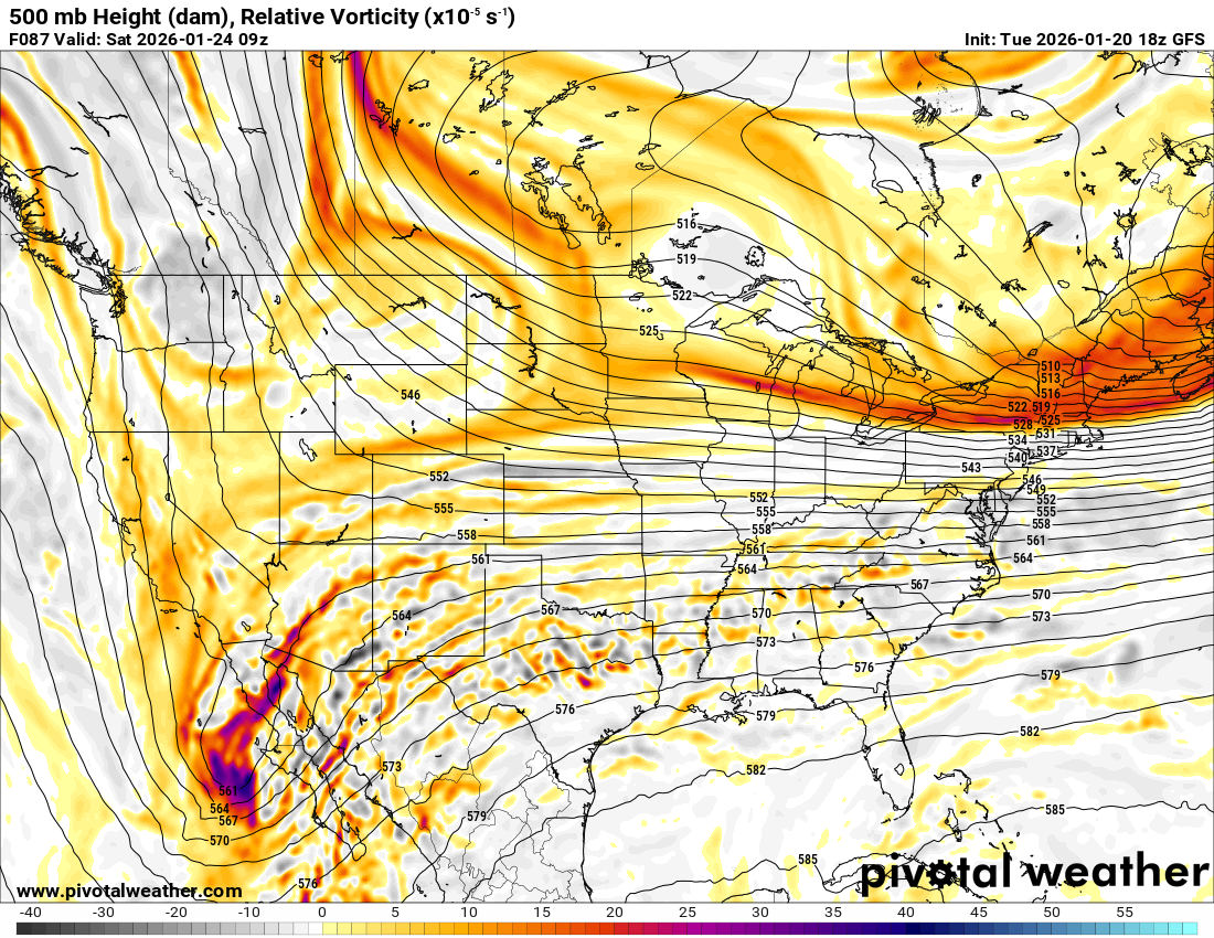
The HP is showing up big on this run. 1048 at 87 sitting on Minnesota/Iowa border
-
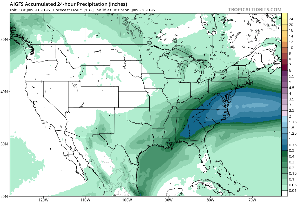
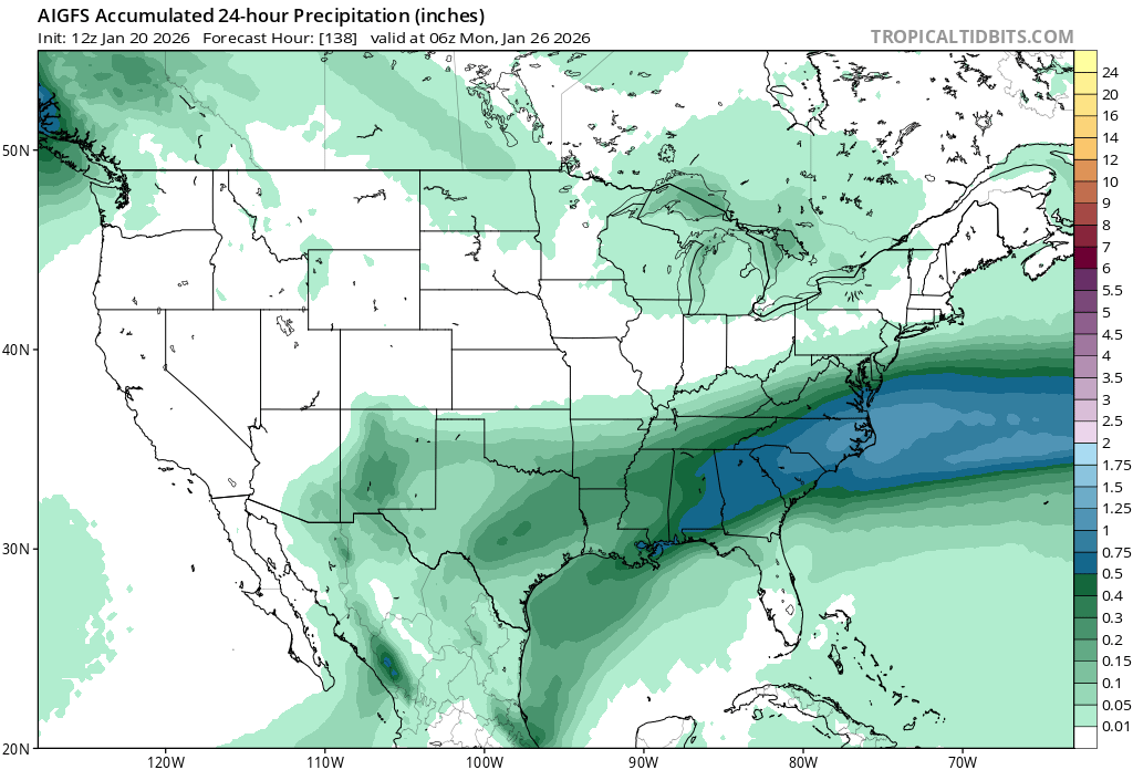
Absolutely...this is through 06Z Monday...18Z on top, 12Z on bottom: (ETA: Ninja'd by @Weather Will, and his graphics are better than the TT ones!)
-

Central PA Winter 25/26 Discussion and Obs
paweather replied to MAG5035's topic in Upstate New York/Pennsylvania
After the hiccup at 12z the 18z GFS seems to back the more northerly extent of the QPF. -
Here we go
-
Never seen Raleigh this confident 4 days out NCZ021-210900- Forsyth- Including the city of Winston-Salem 408 PM EST Tue Jan 20 2026 .TONIGHT...Clear, cold with lows around 18. North winds around 5 mph this evening, becoming light and variable. .WEDNESDAY...Mostly sunny. Highs in the mid 40s. Southwest winds 5 to 10 mph. .WEDNESDAY NIGHT...Partly cloudy. Not as cool with lows in the lower 30s. Southwest winds around 5 mph. .THURSDAY...Mostly sunny. Highs in the mid 50s. West winds around 5 mph. .THURSDAY NIGHT...Partly cloudy in the evening, then mostly cloudy with a chance of rain after midnight. Lows in the mid 30s. West winds around 5 mph, becoming north after midnight. Chance of rain 40 percent. .FRIDAY...Cloudy with a 50 percent chance of rain. Highs in the mid 40s. .FRIDAY NIGHT...Mostly cloudy. A slight chance of rain and snow in the evening, then a chance of snow after midnight. Much colder with lows around 20. Chance of precipitation 40 percent. .SATURDAY...Snow. Light snow accumulation. Much colder. Near steady temperature in the lower 20s. Chance of snow 90 percent. .SATURDAY NIGHT...Snow, cold with lows around 15. Chance of snow near 100 percent. Wind chill values as low as zero. .SUNDAY...Snow likely, mainly in the morning. Cold with highs in the upper 20s. Chance of snow 70 percent. Wind chill values as low as zero. .SUNDAY NIGHT...Partly cloudy with a chance of snow in the evening, then mostly cloudy after midnight. Cold with lows 10 to 15. Chance of snow 50 percent. .MONDAY...Partly sunny. Highs in the lower 30s. .MONDAY NIGHT AND TUESDAY...Mostly clear. Lows zero to 5 above zero. Highs in the lower 30s.
-
Looking like an earlier start time too. Glad to see the delayed trend ceasing for at least one run.
-
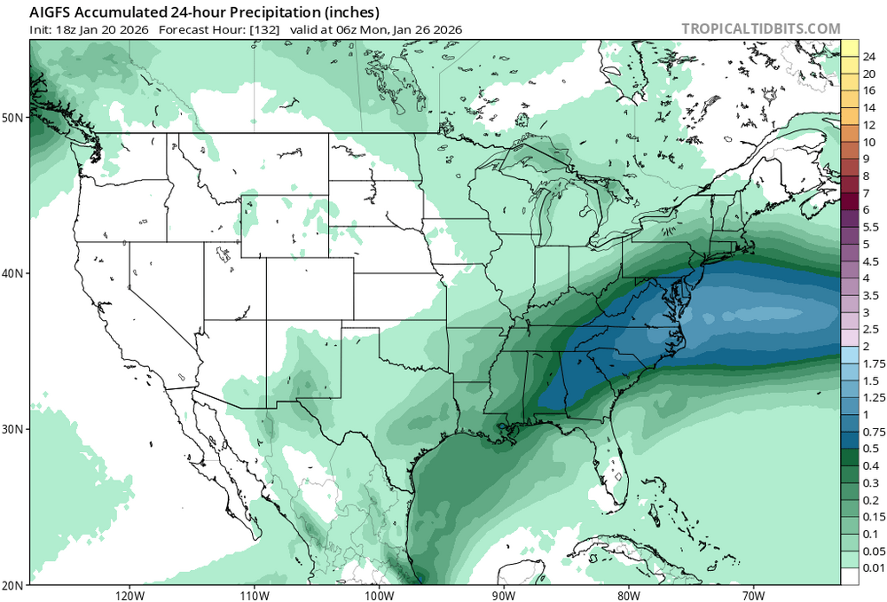
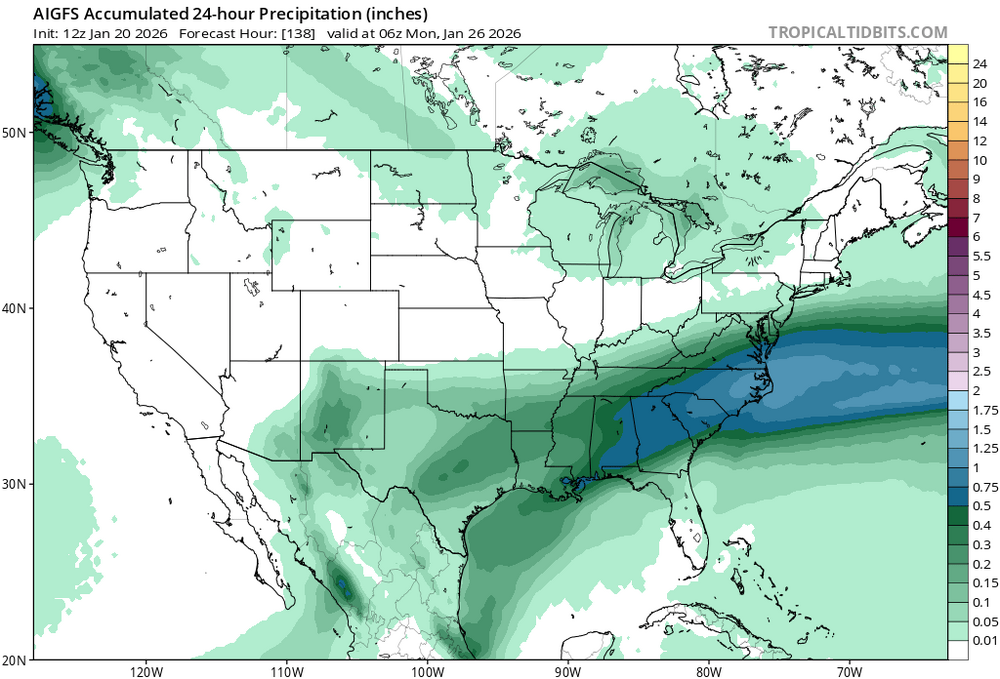
Healthier precip shield at 84...
-

January 2026 regional war/obs/disco thread
ineedsnow replied to Baroclinic Zone's topic in New England
AI GFS way north of 12z