All Activity
- Past hour
-
Aren't we still right near solar max (like 2002-03 and 2014-15, which were both great, el nino/+ENSO winters)?
-
Is a record-breaking east-based La Nina the most historically favorable state for cold? I think the global warming skew is significantly helping your case An actual low in the N. Pacific is not bad for NE, US cold - wavelengths never get that long on average. It's more in the Upper Midwest. There has been a slight historical tint of anomalous troughs in the arctic in the historical east-based Nino dataset 48-25, more examples than a few is more random there.
-
94
-
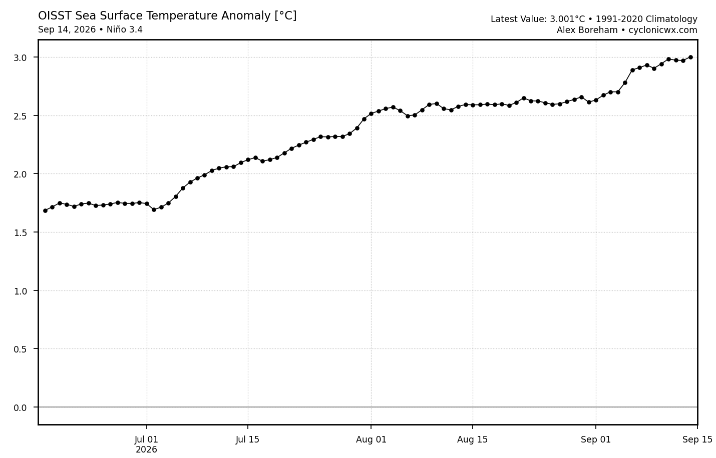
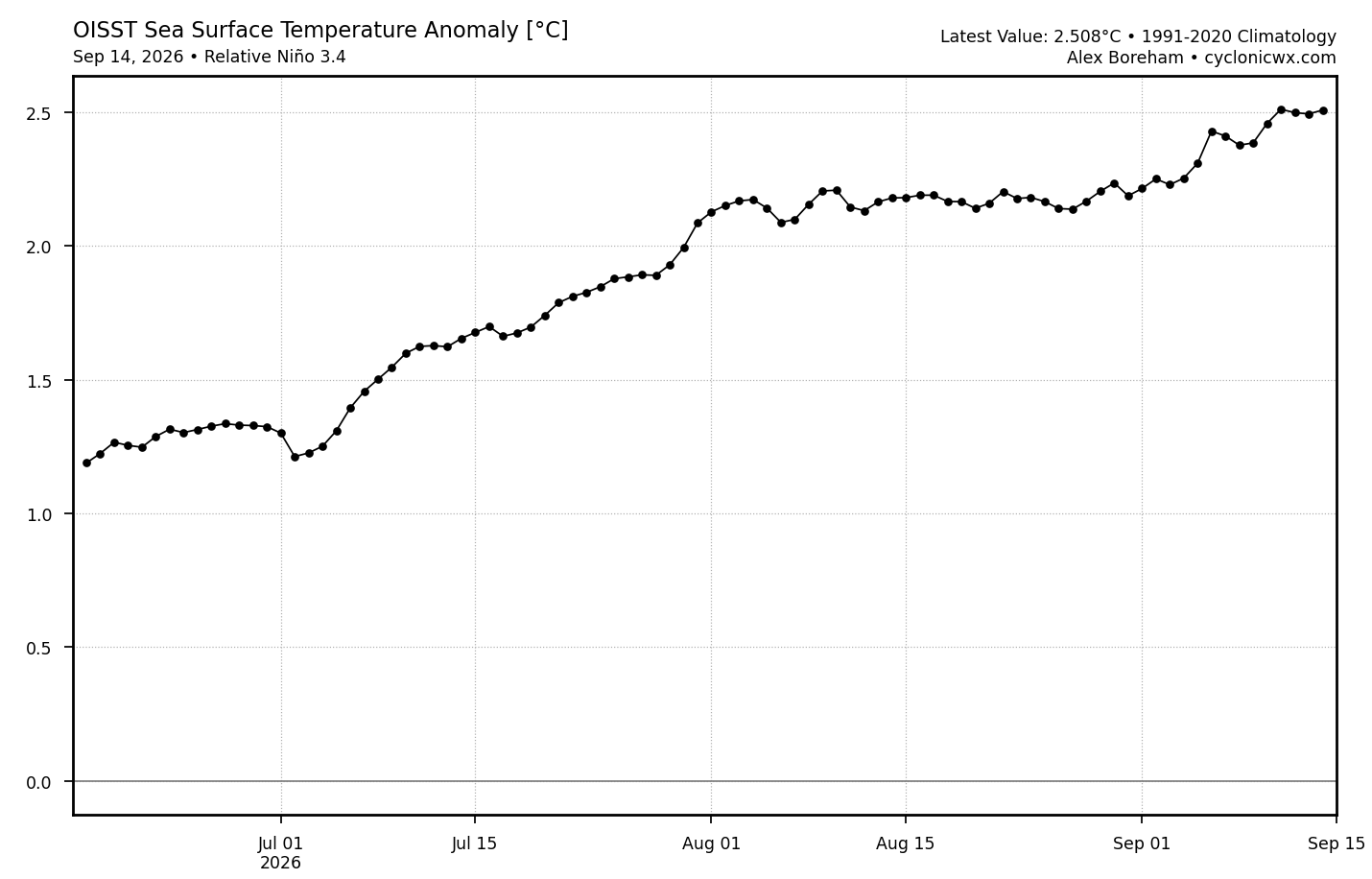
Jeff, I am gonna need you to calculate the area under each of those curves so that we can better analyze the true capacity of oceanic heat. Energy potential is to be calculated in gigawatts. I got to know if this can power my Delorean back to cooler temps.
-
-
76 the high so far Absolutely gorgeous top 10 day of season
- Today
-

2026-2027 Record-breaking El Nino
LakePaste25 replied to Stormchaserchuck1's topic in Weather Forecasting and Discussion
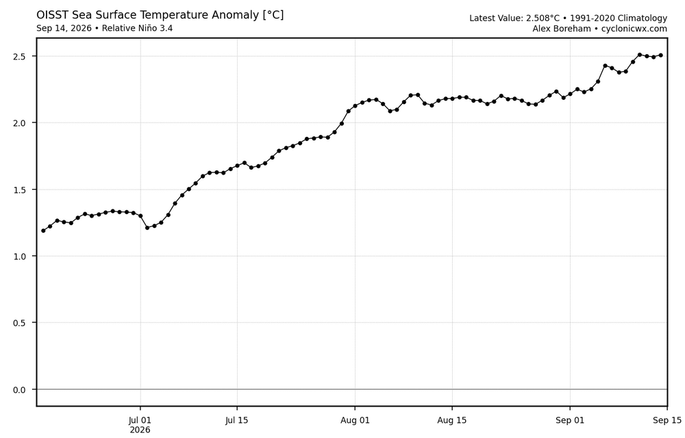
Officially crossed +3C on ONI and +2.5C on RONI!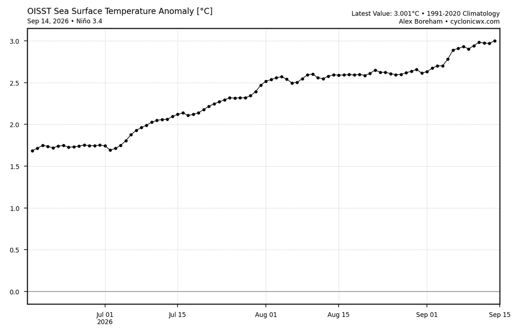
-
I am hoping for slightly less above normal until mid October. The high 90's to 100's have been rough especially with the humidity we have been getting. I think 2009 it was hot until Halloween and then it fell on it's face and got cold? I hope we get slightly less hot sooner than that.
-
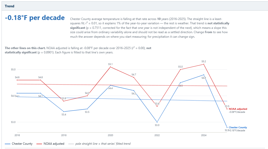
(002).thumb.png.6e3d9d46bca5fe41aab7a74871dd8af8.png) Below is a snapshot of both the raw actual annual average temperatures and the NCEI adjusted for Chester County PA over the last 10 years from 2016-2025. Both trend lines show a cooling period is underway but neither line is statistically significant. Could this indeed be the start of our next cooling cycle in our never ending cycle of climate change?
Below is a snapshot of both the raw actual annual average temperatures and the NCEI adjusted for Chester County PA over the last 10 years from 2016-2025. Both trend lines show a cooling period is underway but neither line is statistically significant. Could this indeed be the start of our next cooling cycle in our never ending cycle of climate change?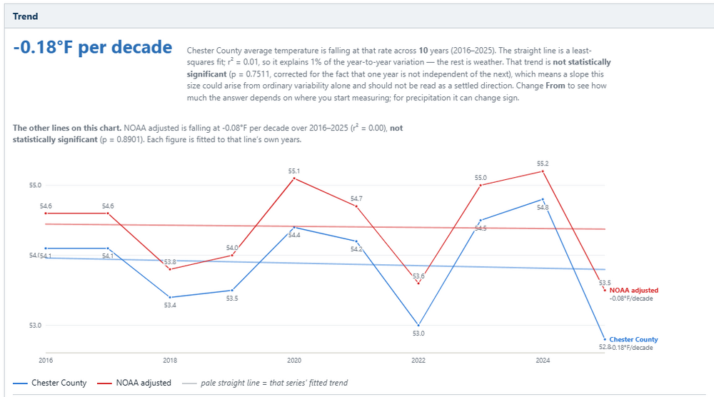
-
Thanks Mike!!
-
Had a quick shower this afternoon. Big, fat raindrops for about five minutes. Helped make things steamy... not in the good way.
-
 india pharmacy international shipping: India Generic Store - pharmacy websites
 -

2026-2027 Record-breaking El Nino
mitchnick replied to Stormchaserchuck1's topic in Weather Forecasting and Discussion
Definitely expect some adjustments over the next 2 months...hopefully not in the wrong direction. After that, it's December with the daily weeklies update! What a drug this hobby can be! Lol -

E PA/NJ/DE Autumn 2026 Obs/Discussion
MGorse replied to PhiEaglesfan712's topic in Philadelphia Region
A low of 51.5F early this morning. Quite refreshing! I see the Mount Pocono airport got down to a crisp 39F. -

2026-2027 Record-breaking El Nino
40/70 Benchmark replied to Stormchaserchuck1's topic in Weather Forecasting and Discussion
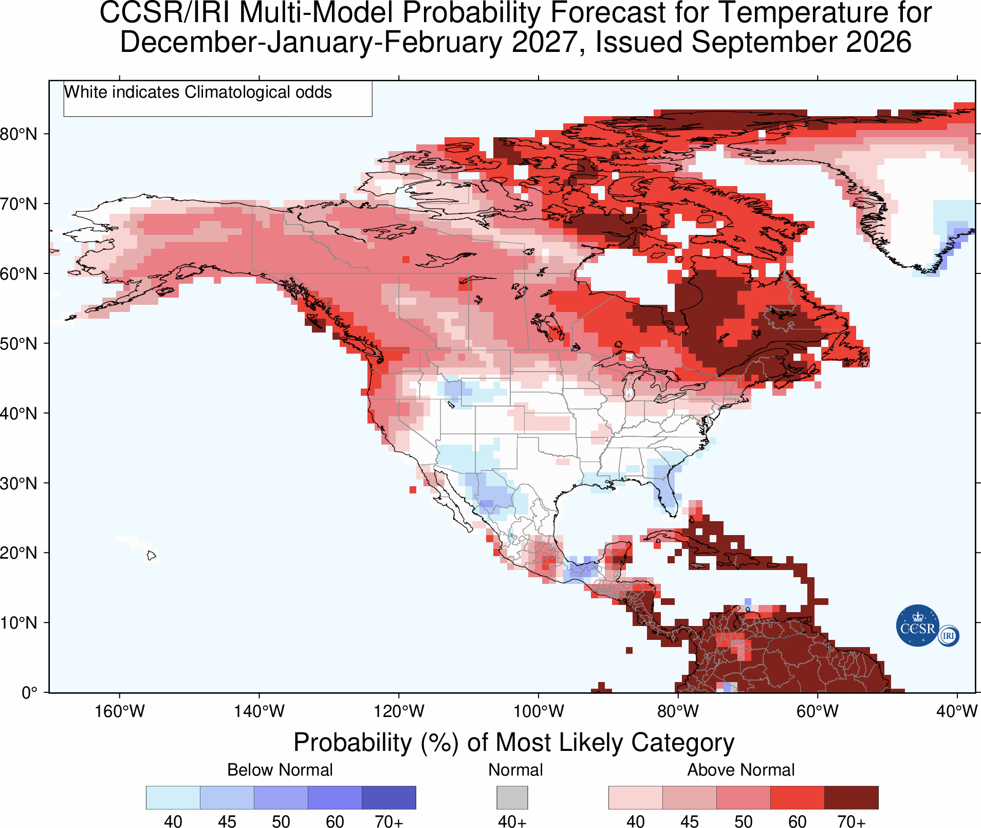
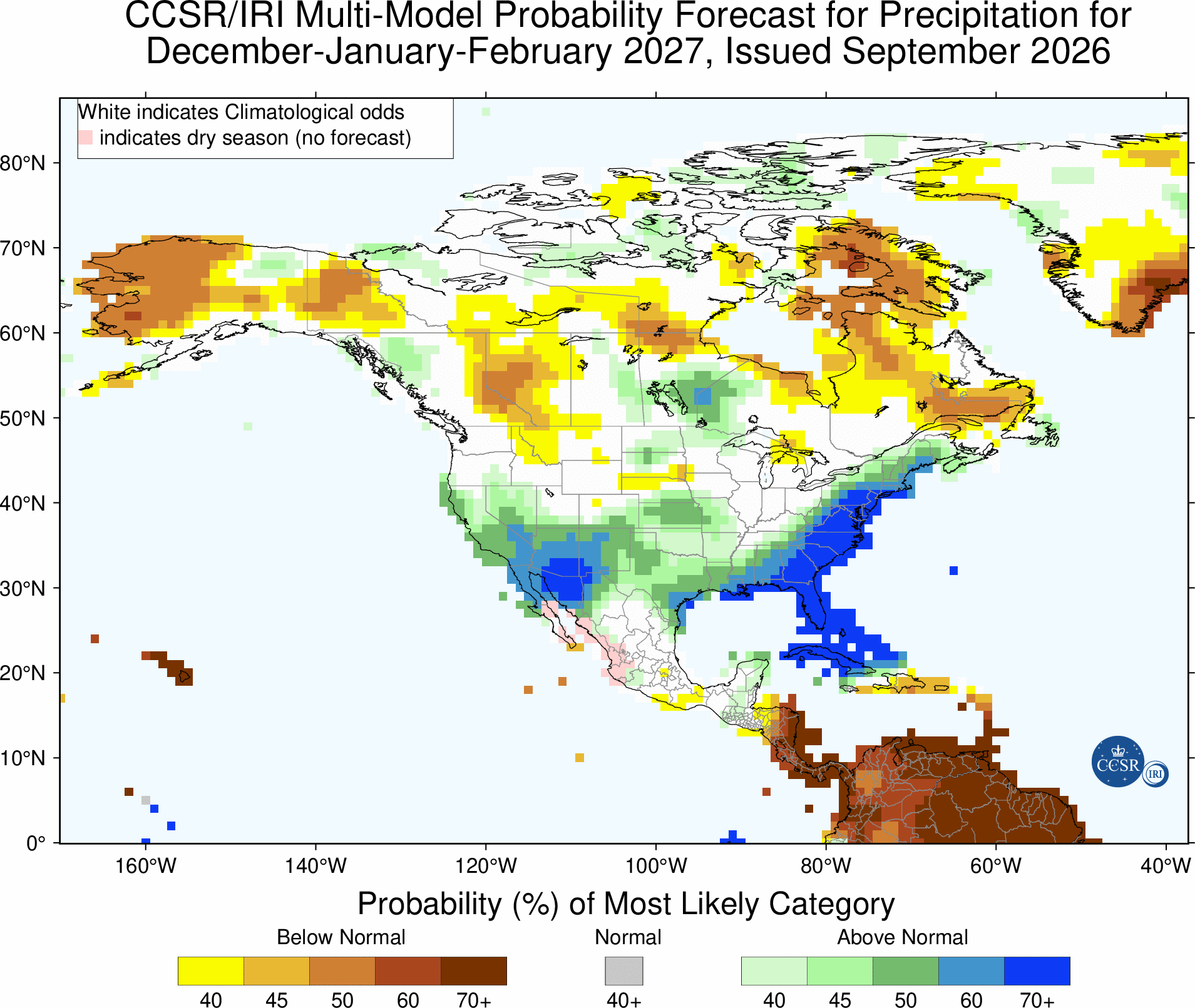
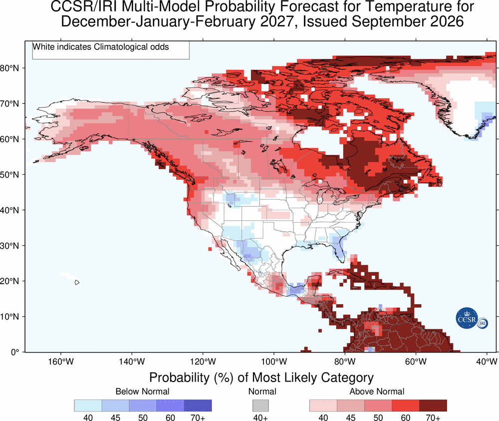
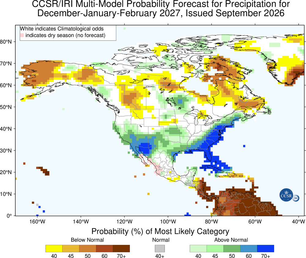
This should be pretty accurate, so forecast maybe about right for the northeast and could be a hair warm south of about DC....but another trend we have seen is for the ridges to verify south of forecast, which places "too cool" on the able for the NE forecast, if that were to be the case. -
I never expect cooler weather anyways till the first 5 or 10 days of October, September for the most part is still warm and humid here but on occasion you do get lucky and it cools sooner.
-
What’s this on the 12Z UKMET? For the first time, it has a TC (TD) in the C Gulf late in the run with it moving slowly WNW and strengthening: NEW TROPICAL CYCLONE FORECAST TO DEVELOP AFTER 150 HOURS FORECAST POSITION AT T+150 : 25.0N 90.7W LEAD CENTRAL MAXIMUM WIND VERIFYING TIME TIME POSITION PRESSURE (MB) SPEED (KNOTS) -------------- ---- -------- ------------- ------------- 0000UTC 22.09.2026 156 25.0N 90.4W 1008 23 1200UTC 22.09.2026 168 25.5N 91.7W 1005 31
-
Who hacked your account Chuck? You're making me nervous with your positivity.
-
way too early 8 days out is an eternity...OP models are not good after about day 5
-
good interview here about Nats pitching with my man Sean Doolittle (go hoos!!!) https://blogs.fangraphs.com/sean-doolittle-talks-washington-nationals-pitching/
-
that's a good point - might take some time to get right if trust issues like this are at play.
-
75 degrees and partly sunny in Winston in the afternoon is what we prayed for
-
2026-2027 Record-breaking El Nino
40/70 Benchmark replied to Stormchaserchuck1's topic in Weather Forecasting and Discussion
It comes down to the position of the ridge, which should be over se Canada, so I doubt it will be too warm in the NE. Maaaaaaybe the se....... 23-24 it was over se Canada, so it was too cool anywhere near that ridge. Last year it was too cool in the SW, under the ridge. -
2026-2027 Record-breaking El Nino
mitchnick replied to Stormchaserchuck1's topic in Weather Forecasting and Discussion
Never argue with a March map like that one! Lol It has been consistent fwiw. -
2026-2027 Record-breaking El Nino
mitchnick replied to Stormchaserchuck1's topic in Weather Forecasting and Discussion
Euro was too cool in 23/24 in the east, then too warm in 24/25 and again last winter. I really don't know what to think about this winter except it's a bit warmer than Jamstec, Cfs2, NMME and JMA. I think the Cansips is a bit behind the curve and will eventually look like the rest of seasonal modeling, more or less.