All Activity
- Past hour
-
Mammoth latest webcam snap shot. This is just an incredible storm for them. When they are getting blitzed, we are having extremely warm weather as a rule. The cold shot we will have for a couple of days Sunday-Tuesday is unusual for us when they are getting hammered. (They have another 3-5 feet event predicted Tuesday and Wednesday) The PNA is neutral, near record cold in Alaska is possible, and the AO/NAO are opposite of where we need them. It will be hard to turn that around enough to have many winter chances for non-elevated areas before the season is essentially over in mid-March. We may see flakes in the air, but impactful snow for most areas is likely done until next late November or December. All in all the winter was decent here for frozen, but could have been much better with the two cold periods we got. The Ohio Valley, and Northeast cashed in this winter. The Rockies struggled mightily but winter ends there in May, so all hope isn't lost for them.
-

Feb 22nd/23rd "There's no way..." Storm Thread
Terpeast replied to Maestrobjwa's topic in Mid Atlantic
If it were up to me, tomorrow midday after 12z runs come in would probably be a good time to issue watches. One thing going for NWS is that this storm doesn’t happen during commute, at least until it’s over New England -

“Cory’s in NYC! Let’s HECS!” Feb. 22-24 Disco
ineedsnow replied to TheSnowman's topic in New England
GEFS west at 78 -
Gefs are coming in more tucked in wooof
-
And could, But, You, Luke and i need more longitude for this as well as lat at others expense.
-
Ukie looks quite a bit different at 33. More interaction between the NS and ss
-

Feb 22nd/23rd "There's no way..." Storm Thread
LeesburgWx replied to Maestrobjwa's topic in Mid Atlantic
Rain just cleansed the roads too. Could be crazy times if GFS is right -

Feb 22nd/23rd "There's no way..." Storm Thread
baltosquid replied to Maestrobjwa's topic in Mid Atlantic
UKMET is more GFS like with the NS at 39. We'll see how that translates. -
I agree with you. A couple of inches possible around NYC..
-

Feb 22nd/23rd "There's no way..." Storm Thread
Eskimo Joe replied to Maestrobjwa's topic in Mid Atlantic
This is going to happen. I finally have a weekend where I'm not on call at work, and my wife just surprised me with the last tickets to the Lord of the Rings: Return of the King in Frederick Sunday evening. I've never seen this in theaters and it's the last showing in the entire state. -

Feb 22nd/23rd "There's no way..." Storm Thread
stormtracker replied to Maestrobjwa's topic in Mid Atlantic
See yall on Sunday -

“Cory’s in NYC! Let’s HECS!” Feb. 22-24 Disco
Go Kart Mozart replied to TheSnowman's topic in New England
Anyone have an early Ukie? -
GEFS are west of 18z
-

Feb 22nd/23rd "There's no way..." Storm Thread
ravensrule replied to Maestrobjwa's topic in Mid Atlantic
24” is definitely worth forgoing 12”. -

Richmond Metro/Hampton Roads Area Discussion
ORFDawg2013 replied to RIC Airport's topic in Mid Atlantic
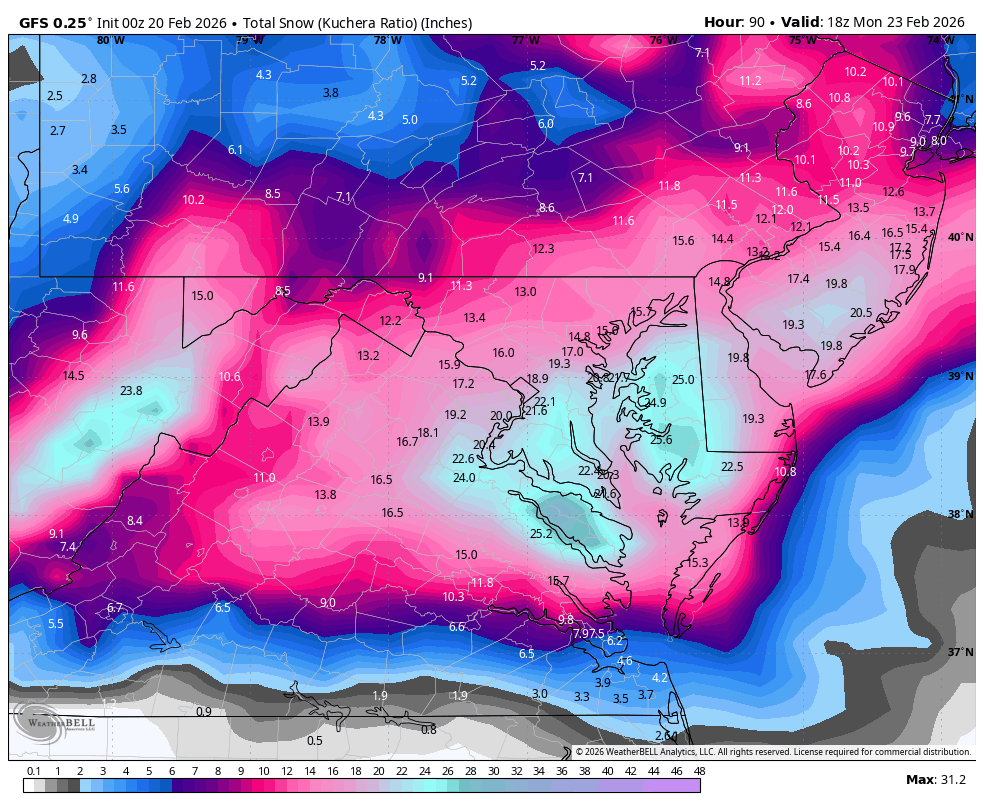
00z GFS
-
Almost the entire southeast is now in severe drought with extreme drought quickly expanding. Last weekends rain did very little and this week drying up has turned away yet another opportunity to dent the drought. We could really use a gfs-like scenario for drought relief with Sundays system
-
Feb 22nd/23rd "There's no way..." Storm Thread
stormtracker replied to Maestrobjwa's topic in Mid Atlantic
This is IMPORTANT yall. I'm in a precarious situation. The Euro will determine if weeks worth of shut out is worth it. This is a PDS situation. -
“Cory’s in NYC! Let’s HECS!” Feb. 22-24 Disco
Go Kart Mozart replied to TheSnowman's topic in New England
I thought it looked great at h500 at 72hrs, then made a huge convection jump at 78hrs. -
Feb 22nd/23rd "There's no way..." Storm Thread
ravensrule replied to Maestrobjwa's topic in Mid Atlantic
My bedroom is your bedroom. My wife will sleep on the couch. -

Feb 22nd/23rd "There's no way..." Storm Thread
Solution Man replied to Maestrobjwa's topic in Mid Atlantic
Got 4 beds in Haymarket -

“Cory’s in NYC! Let’s HECS!” Feb. 22-24 Disco
H2Otown_WX replied to TheSnowman's topic in New England
LBSW? -

Feb 22nd/23rd "There's no way..." Storm Thread
nw baltimore wx replied to Maestrobjwa's topic in Mid Atlantic
Caught me. -

Feb 22nd/23rd "There's no way..." Storm Thread
Snowman. replied to Maestrobjwa's topic in Mid Atlantic
00z GEFS went west cluster hugs the coast more -
.thumb.png.4150b06c63a21f61052e47a612bf1818.png)
“Cory’s in NYC! Let’s HECS!” Feb. 22-24 Disco
HIPPYVALLEY replied to TheSnowman's topic in New England
Could end up a drift tease of clouds and light snow but better than tracking cold fronts. -

Feb 22nd/23rd "There's no way..." Storm Thread
balltermen replied to Maestrobjwa's topic in Mid Atlantic
GFS:East coast snowstorms in a Nina DCA:Measuring