All Activity
- Past hour
-
Sunday is Hiney
-
Tightening up near Marcellus, MI
-
46 now with the heat on. Low 80s yesterday with AC on. AC might be back on tomorrow lol. BDCFs are a thing this time of year with HP to the NE. Looking forward to next week, which looks Fall-like with low temps around freezing possible a couple nights. I will be in Rehoboth mid next week. Forecast is sunny with temps in the 50s. Perfect.
-
Sat still has the chance to be mostly ass for many. CT may hold it off for most of the day.
-
Nice ragged/elongated wall cloud passed just southeast. It was trying it's best to wrap up. Had a period of quarter size hail and torrential rain from core right after the wall cloud passed by.
-
I give today a grade of A+ In classic early spring shit show weather for New England.
-
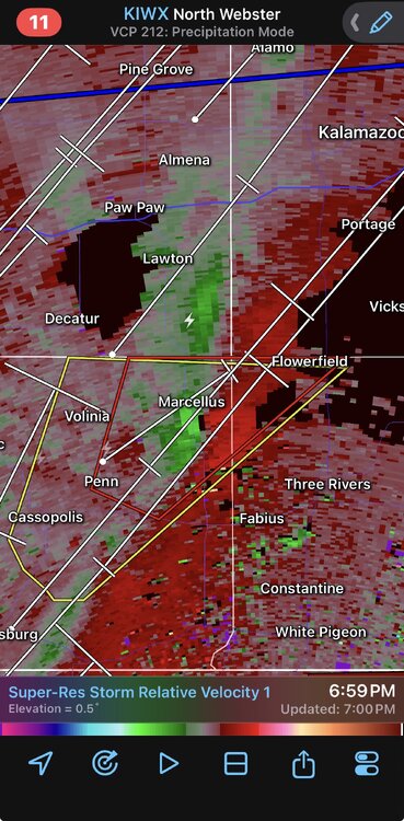
Storm in Cass County MI aka “new tornado alley” is trying to get its act together.
-

Central PA Spring 2026 Discussion/Obs Thread
canderson replied to Voyager's topic in Upstate New York/Pennsylvania
I love 50 degree drizzly days so much. I wish we had them more often. -
it's giving it a go as it approaches you.
-

Central PA Spring 2026 Discussion/Obs Thread
Voyager replied to Voyager's topic in Upstate New York/Pennsylvania
Warm west/cold east is getting old... -

2026-2027 El Nino
40/70 Benchmark replied to Stormchaserchuck1's topic in Weather Forecasting and Discussion
A few Modoki in there... -
Low topped event. Shallow CAPE.
-
Saturday looks good. Sunday looks ass-ish
-
2026-2027 El Nino
40/70 Benchmark replied to Stormchaserchuck1's topic in Weather Forecasting and Discussion
I would agree. -

Central PA Spring 2026 Discussion/Obs Thread
pawatch replied to Voyager's topic in Upstate New York/Pennsylvania
Repeat of the other week. -
2026-2027 El Nino
40/70 Benchmark replied to Stormchaserchuck1's topic in Weather Forecasting and Discussion
Yes, for the most part, but my area did get that unexpected whopper just prior to Xmas, on 12/23. -
Maybe a dumb question but why does the SPC Mesoanalysis show CAPE in Illinois? I doubt we've accumulated 1000 J/kg under clouds all day.
-
I definitely don't miss the frustrating ocean induced cool weather that define Long Island springs. I remember being frustrated seeing NJ in the 80s and my house being in the 50s with ocean mist and fog. Or sometimes it would be nice and in the 70s or 80s north of Long Island (CT, upstate NY) and LI still stuck in the 50s or 60s.
-
Saturday looks solid 65-70 I-90 South similar to yesterday
- Today
-
We had one in 2016
-
Storms trying to get going locally but nothing exciting. Not even much lightning.
-
Huge winter incoming.
-

Central PA Spring 2026 Discussion/Obs Thread
Superstorm replied to Voyager's topic in Upstate New York/Pennsylvania
Huge contrast across state. 47 Lancaster 82 Pittsburgh . -
Those storm cells near the Quad Cities should be watched very closely. There seems to be some issues with other nearby cells interfering, but the cells over McCausland and Colona might be starting to get that “look.” The tornado-warned storm moving towards Toronto, IA also bears watching; it’s about to merge with the line behind it.
-
Sun breaking out a bit imby


