All Activity
- Past hour
-
You should see my grandmothers needle point. She has this.
-
In 1869 it was a week later.
-
Hrrr back south. We get nothing
-
Good stuff on EPS
-
In 1869 it would have been snowing at my house. I'm pissed.
-

Early Monday morning 2/16 last minute event OBS/Discussion
JTA66 replied to The Iceman's topic in Philadelphia Region
Maybe if we started threads for incoming torches. N’ah it probably doesn’t work that way. Virga, 43F/DP 30F. I wouldn’t mind a few hours of rain, if just to wash some salt off the car. -

Is we back? February discussion thread
Damage In Tolland replied to mahk_webstah's topic in New England
Any chance Wednesday nights deal is some light icing interior and snow north of 90? -
The system that improved the most today on both EPS and Euro Skynet was Friday night/early Saturday. Doesn’t get shredded as much but also pretty cold too. Monday still has the most upside imho, but Friday night could end up pretty good too if we trend it like today. Monday definitely got some more support too today. But being 8 days out makes it less meaningful when you see a model shift.
-
Don't know but I would hit EURO SKYNET all day
-
We have had some timely blocking episodes in recent winters, but not anything I would consider sustained. A transient -NAO doesnt mean there is an atmospheric block. Maybe 2009-10 was a unicorn and we never see that again, but I hope that's not the case.
-
Let’s split the difference.
-
Kind of funny AI is suppressed mid week and euro legacy models are congrats Dendrite.
-
You can see it here on the 174hrs ensemble slp anomaly map. Scroll to 180hrs, 186hrs and 192hrs. https://www.tropicaltidbits.com/analysis/models/?model=eps®ion=us&pkg=mslpa&runtime=2026021512&fh=174
-
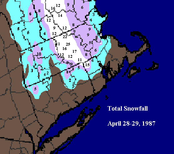
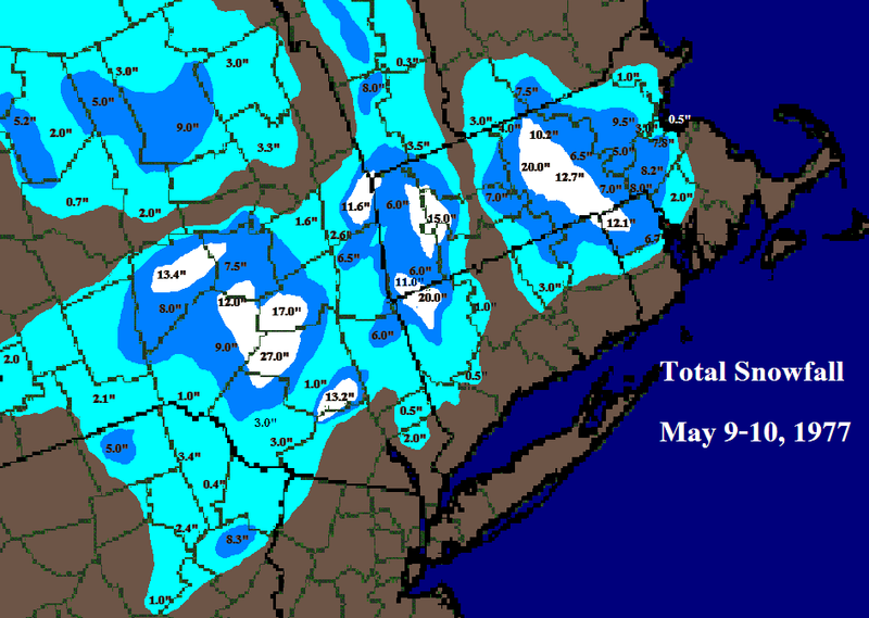
Given it was also my very early days of making maps, I put north foster coop too far north. It can extend a bit further south with the 12”+ on both maps.
-
I did maps for April ‘87 and May ‘77 almost 20 years ago. They are of course, primitive MS paint jobs but they still give a decent idea. Only annoying thing is for some reason I did not use to nearest tenth in the April ‘87 map.
-
I dunno. This just doesnt look like a a winner baby, not for our latitude. Now a stronger low along the coast, you would have something up your way at least. It doesnt really deepen until its well offshore though. And the High to the NE with lower pressure to the NW, kinda inverted from what we want, esp in a marginal Pacific airmass. Not like we have an antecedent cold air mass in place, but retreating. Its freaking mild air leading in. I think we agree in general, but I just don't think it applies in all marginal situations. A slightly stronger High to the north, even with the same weakish low and track might have been enough to tip the scales up your way. Its the fine details in a marginal setup that can make the difference.
-
Guess that was fun. For a minute. Didn’t think about the miller B idea. This will end poorly unless you are in Scranton.
-
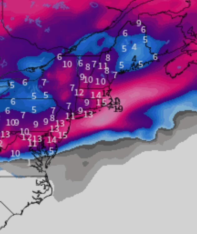
Even almost a quarter give ORH 20”+. Definitely the most aggressive in a while. Lot of ways for it to screw up but the benefit of having like 3-4 different waves is you also have a decent chance of one or two of them working out.
-
Light rain in Fallston - any precip is welcome at this point.
-
I have... By Euro I had 'Euro product suite' in mind.
-
4 shots
.png.d3e359b72998c7460476696ccfa304a9.png)
.png.299b4546919fab94b44f17e3e069d2dc.png)
.png.0f1cb617a51b129ac897906ecd6fcc04.png)
.png.164851302717dcbbdf4b933e7df8fd6c.png)
-

Presidents' day Snow potential
Stormlover74 replied to WeatherGeek2025's topic in New York City Metro
Yep -
If it’s already germinated, yes. Your rye is going to die off when we start getting warm anyways, so you’re fine. I’d only avoid pre emergent if you have plans to overseed/add plugs to the existing Bermuda.
-

E PA/NJ/DE Winter 2025-26 Obs/Discussion
Ralph Wiggum replied to LVblizzard's topic in Philadelphia Region