All Activity
- Past hour
-

Winter 2025-26 Medium/Long Range Discussion
Baum replied to michsnowfreak's topic in Lakes/Ohio Valley
Well, however it plays out well ahead of the game this season. -
6z Euro
.thumb.png.b6d5dc9d1b1de02efbae390f6f1c32c4.png)
-
2 inches after this 6.1 total
-
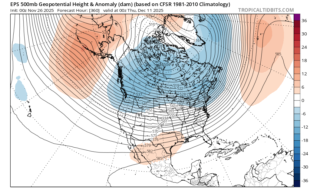
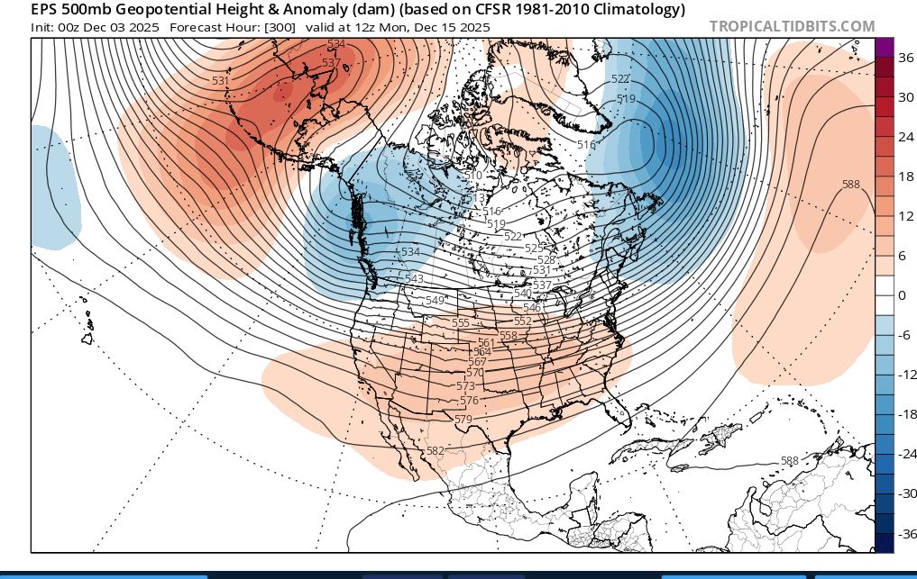
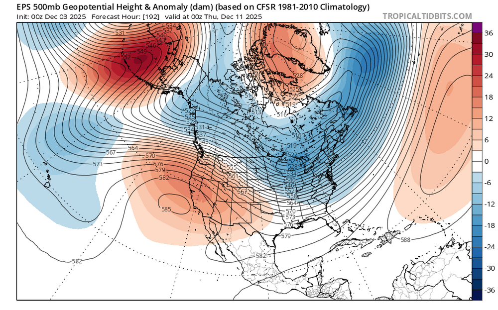
I'd be careful in cancelling any warmup because both ensembles try (operational word, "try") to send a trough into the western US giving us a bootleg -PNA. But any warmup appears to be only temporary. Maybe a week or so, or even a few days. When I play out the roll forwards from 11-15 to 6-10, that western trough retrogrades NW and instead pops up a flat ridge there instead, allowing cold air to move SE across the CONUS. For example, comparing 360 hr from Nov 26 against 192 hr from today's EPS run, you can see what I'm getting at. Old run (11/26): New run (today):

-

Central PA Fall Discussions and Obs
mahantango#1 replied to ChescoWx's topic in Upstate New York/Pennsylvania
-
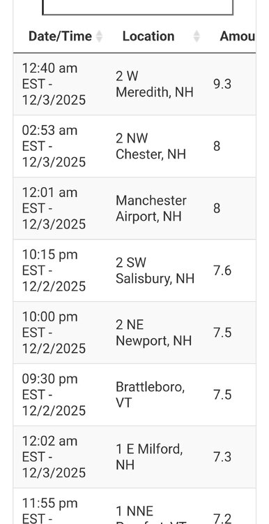
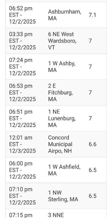
5.0" was the event total here. All snow from 10am to 5pm with 3.3" of accumulation, then about four hours of sleet (0.5" accumulation) with a brief period of freezing rain before going back to snow after 9pm. Picked up an additional 1.2" of snow after the late changeover.
-

December 2025 regional war/obs/disco thread
Kitz Craver replied to Torch Tiger's topic in New England
Active Northern stream from both camps. Something will pop. Bring back the clipper of yore! -

Winter 2025-26 Medium/Long Range Discussion
A-L-E-K replied to michsnowfreak's topic in Lakes/Ohio Valley
looking like a bust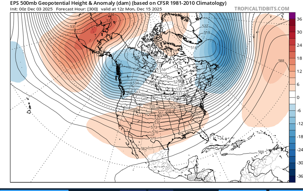
-
Another potential warm up cancelled?
-
End of next week also looks intriguing at h5 but as it looks now on the ens mean we would need a piece of NS energy to dig further south to get us a little storm.
-
We got pieces in place on the ens run. Why sweat the run to run details on the op runs at this range- its literally going to change every run. Just no way to know how the NS vorticity will interact- but we have some digging energy taking the southern route to work with.
-
This has been the reality for the past decade. Bluewave constantly points this out. It's the same kind of storm track too. The only ones that really benefit are anyone around the lakes and C/NNE. Maybe the pattern will flip again one day but we need to see a complete change in the forcing out in the Pacific.
-
Thanks for the heads up. I see that on Google Maps. great
-
Yeah, which means we're due for T-shirt weather this Christmas...but hey, if we can pull off more seasonal Christmas weather two years in a row then that starts a streak...(reference to the movie Major League)
-
Rt2 is closed from gardner to westminster traffic was actually crappy getting off the highway. Not sure what happened
-
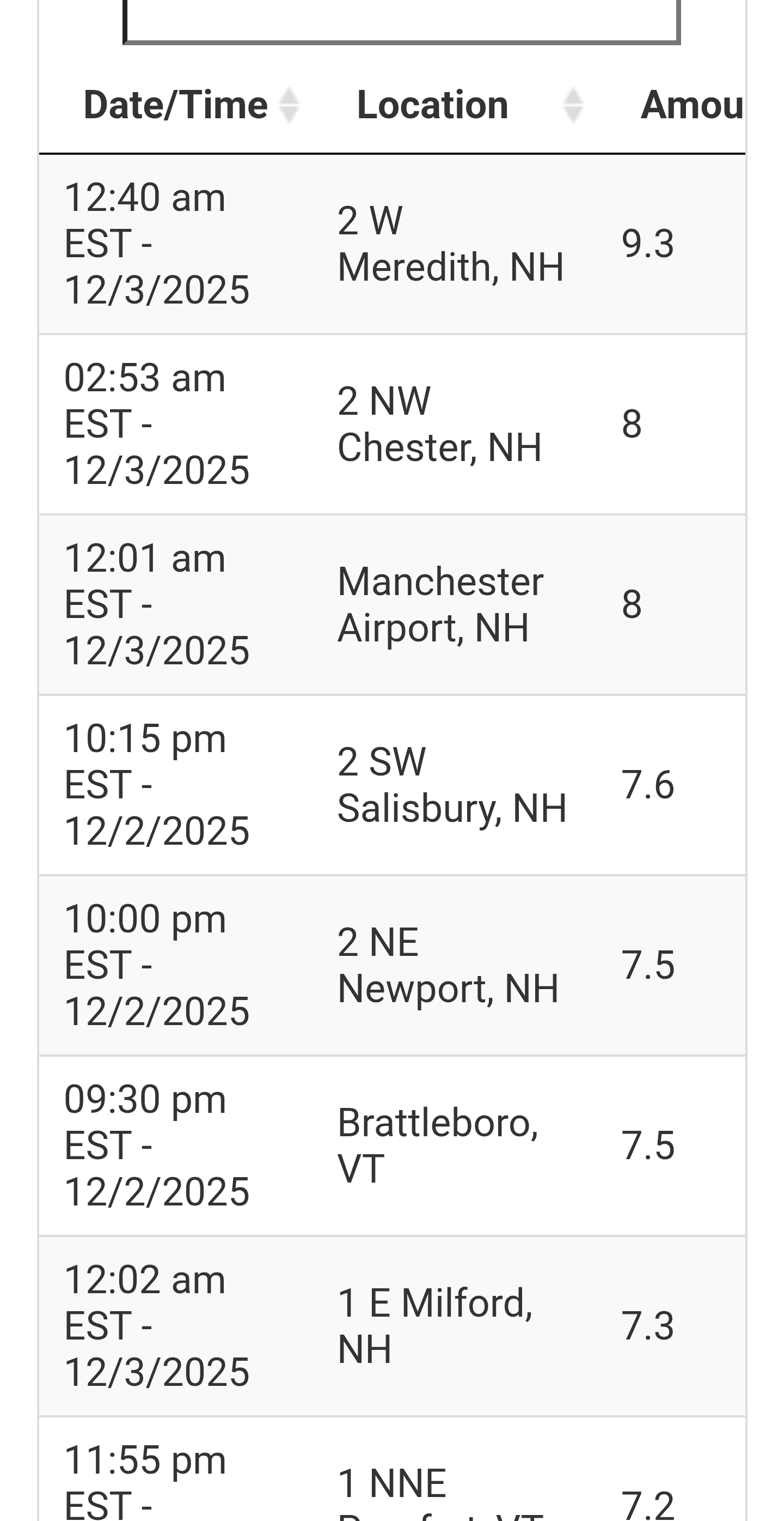
Close to a inch at home. 8 total. Nice storm for us
-
Anyone wondering about the specific tag in this post and may have missed it, I think many of you will enjoy the fine work here:
-
Added another half inch or so overnight. 7.0” total
-

December 2025 regional war/obs/disco thread
Ginx snewx replied to Torch Tiger's topic in New England
Eck cut those damn trees down at GYX doppler. TIA -
13 to 1 damn nice fluffer
- Today
-
-

The Return of the 12/5 Snowstorm
SomeguyfromTakomaPark replied to SnowenOutThere's topic in Mid Atlantic
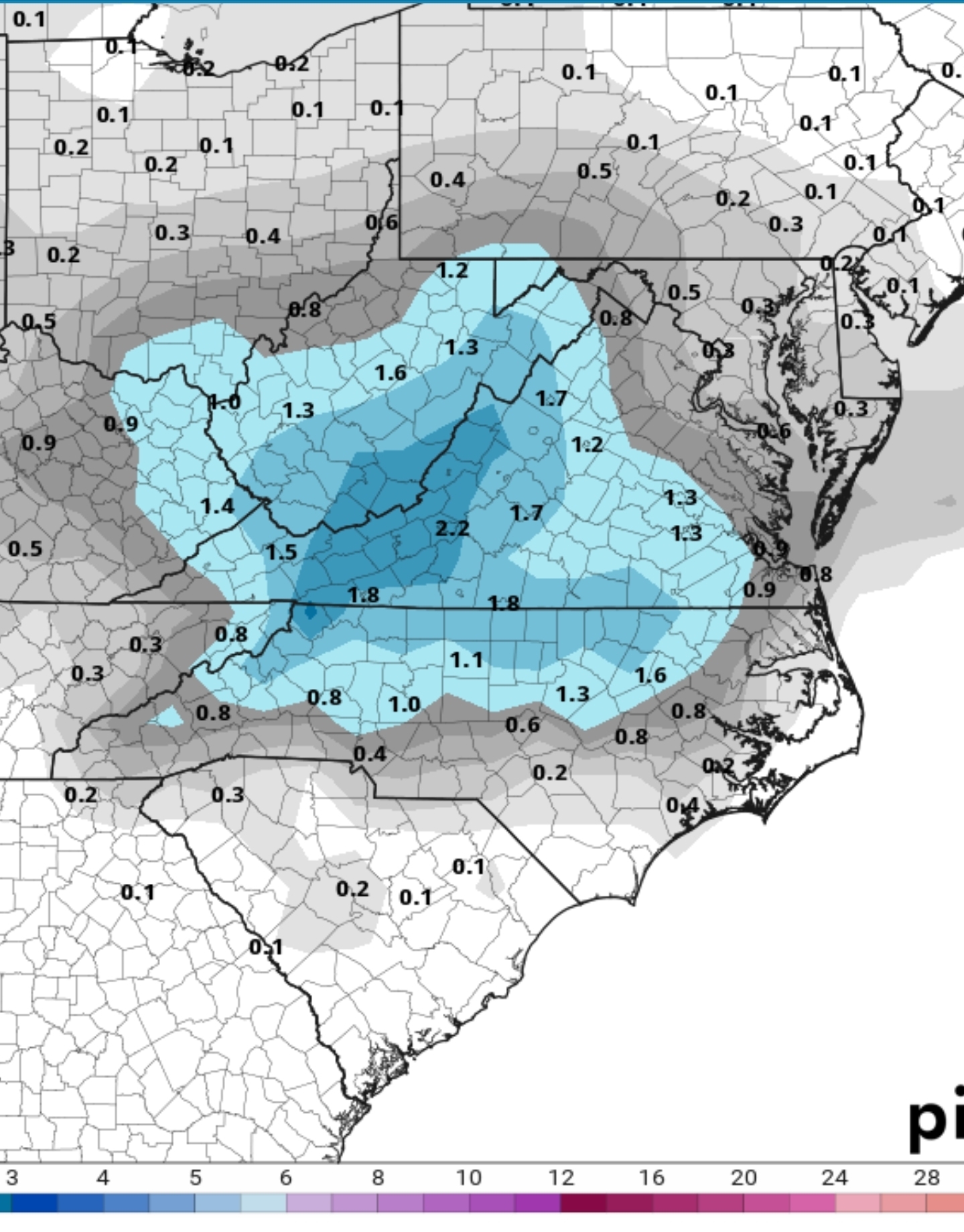
Decent model agreement of a low amplitude shortwave moving across the southern Mid-Atlantic Friday as high pressure retreats offshore. Uncertainties arise in how far north the precipitation will make it. Almost all ensemble and deterministic guidance has enough cold air in place to favor all snow in our FA should moisture make it this far north. There are a few outliers that have rain across the far S of the FA. FWIW, snow and ice has trended up slightly over the past couple of runs. While amounts are forecast to generally be light (an inch or two, perhaps three should a higher end solution verify), the northward shift is notable. Looking at clusters featuring the greatest variance (EOF) regarding amplitude does suggest additional northward expansion is possible. Just something to keep in mind. -
6z GFS very similar to 0z for the Friday system. The Monday system is still there at 6z but not as significant as 0z. Still a good snow up this way for many.
-
0z GEFS just for the Monday system

-
Decent bit more. .

.png.13ef83fa29684c9bb184a9b42b836fbd.png)