All Activity
- Past hour
-
Wicked storm here now. Hopefully I’ll pick up .25”.
-
Home from work finally... Relaxing on the front porch ... Definitely can see lightening far to the north, must be the new cells popping SW of Winchester in Eastern WV... 3rd flood watch of the past 4 days here with a grand total of 0.12 since Friday night... But watching more important lightning in my yard -- fireflies !!!! Not many , nothing like years gone by like the 80s 90s - but more than recently ...
-
You are correct on that. With residual left overs I have .27” in the station for today. I see that line out West but it has to get over the mountains. So thinking it will not stay intact. But could be surprised.
-
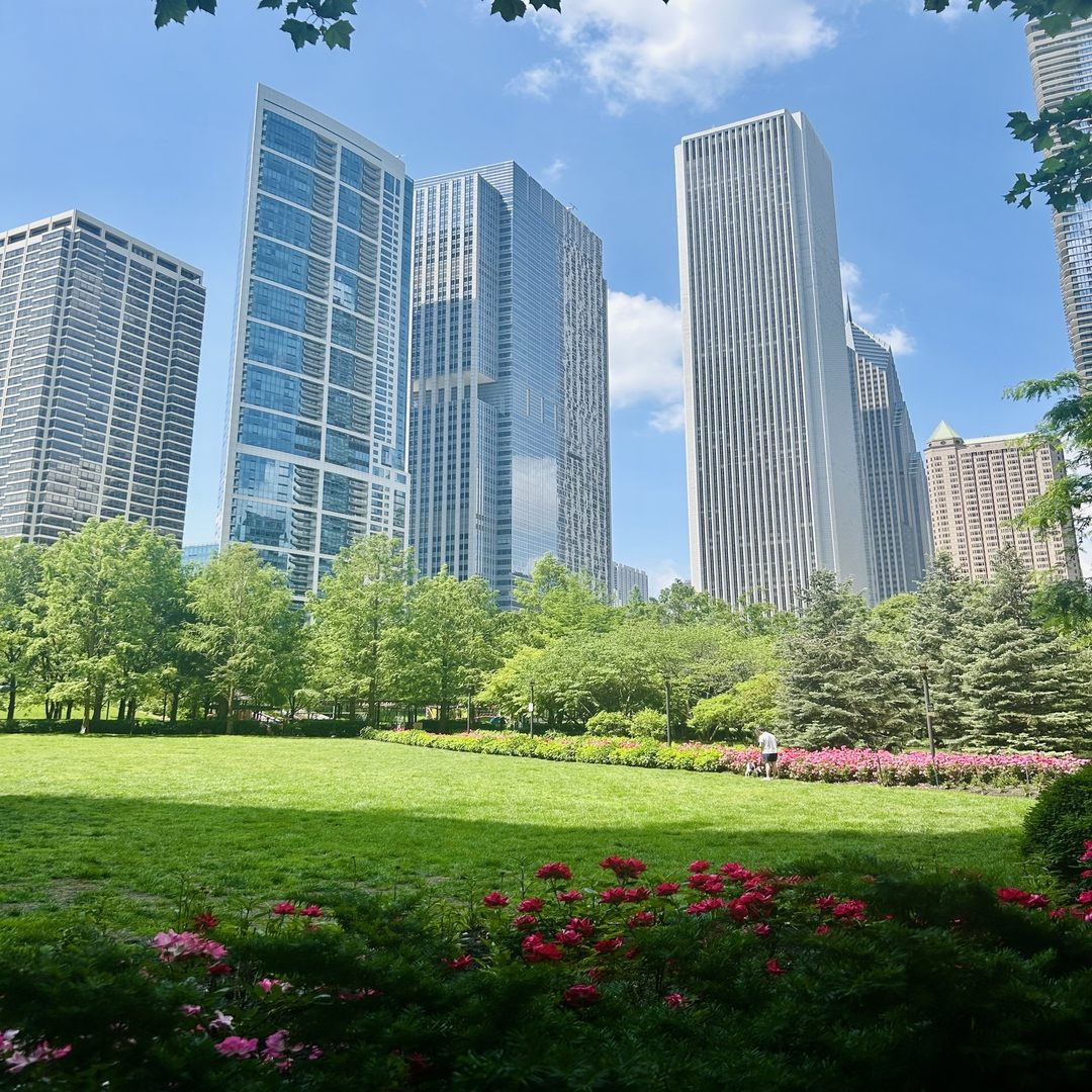
Beautiful day downtown today

-
Wouldn't be so bad but its coming in 2 inch shots in 6 hours or less at a time. Gotten a foot over week of fairly steady rain from some tropical drain outs here and it doesnt flood like this. I've watched the radar and we get these heat bubbles in weak flow coming up out of Indy resulting in some fairly deep convective points that have just set on top of us repeatedly and poured. there was another this afternoon but luckily it was down just South of Anderson. Dropped 2 in in 4 hours there. Same type of setup. We've lost 50% of the green space between here and Indy in the last 15 years. They are paving and concreting their way N at a rapid pace. Its really expanding the heat island effect here. Some models spitting out another 1 to 2 inches here by Thursday AM. I hope it comes slow
- Today
-
Nearby rain gauges are over 0.5” here, but I think I just missed the lightning core. The peaks and valleys really do adjust systems on approach here. Can never really tell what kind of storm we’re getting until gametime.
-

2025 Lawns & Gardens Thread. Making Lawns Great Again
Childude645 replied to Damage In Tolland's topic in New England
https://streamable.com/gstepv -
Tue-Wed are the window for someone to maybe upper 90's. I'd say Tues is the best set up.
-
I haven’t had a real “wake up the neighborhood” night storm in ages
-
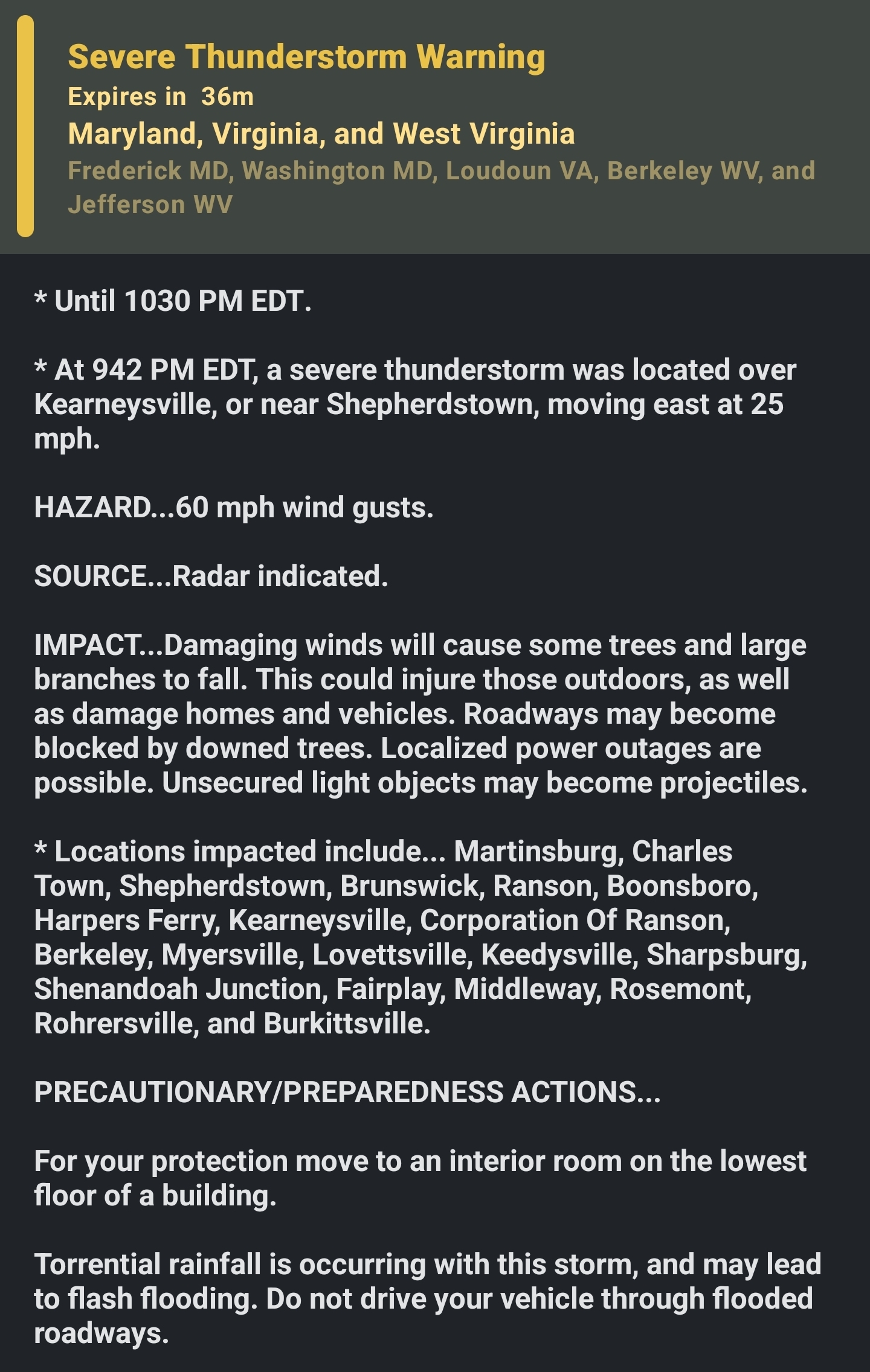
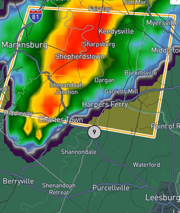
Well that was slightly anticlimactic. Looked all robust rolling in only to do the split that my area is known for. Did pick up .22” so far but all the fury of what was coming in the energy shifted to my North with a new storm to my South near Point of Rocks.
-
Miss those days, or should I say nights.
-
It looks "mid" but the wind threat could be somewhat enhanced, wouldn't rule out some scattered 50-60kt winds with any bows. love the dcape, that's what I was honking about last week and it PERHAPS works out
-
Getting the southern fringes of the storm. Not much wind and a little rain so far. Worst of it looks like it is moving over me now. Downpour now....
-
Nothing severe here, but the creeks will definitely be higher tomorrow morning. Healthy nighttime storm.
-
https://4000.weatherstar.dev/
-
Just took the trash out and wow the lightning. Looks like a crazy storm blowing in.
-
Any urban area will for sure. It will suck but we have been super lucky so hold out this long ….
-
With mid 70s dewpoints midtown HBG might struggle to get below 80 at least one night.
-
Eerily calm here with only a light breeze and thunder now rumbling over the Catoctins.
-
Yep, starting to see lightning in the distance.
-
Well I understand Tip doesn’t care for the verbiage but we are overdue for something. Hopefully this summer
-
looks like install day is almost here !
-

-
This one looks legit on lightning radar, too. It’s on a beeline for mby.
-
I filed for the money. Mine didn’t seem to be cooling right anyway so I figured might as well get paid. I threw the old unit in for now. Haven’t really needed it.


.thumb.png.4150b06c63a21f61052e47a612bf1818.png)