All Activity
- Past hour
-

February 2026 Medium/ Long Range Discussion: 150K Salary Needed to Post
bncho replied to Weather Will's topic in Mid Atlantic
I'd sign for this right now
-
 Not sure how much of the Aigfs is snow but if that's all rain with that track and the cold we've had for weeks that would be a he'll of a gut punch
 -
 With the primary jumping from Indianapolis to Wilmington
 -
Canadian whiffs.
-
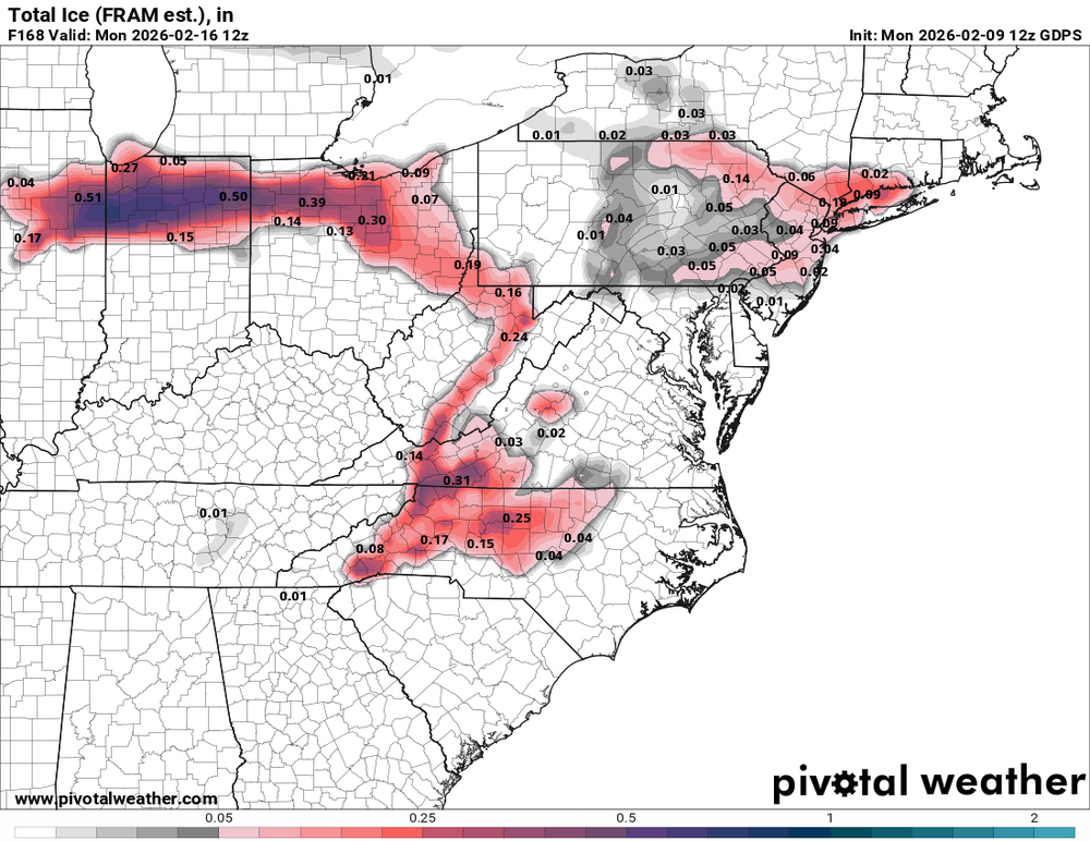
12z CMC comes in a little bit colder and has some ice around the I40 north area

-
Looks like the Hudson is almost completely full of ice even down to the city. https://www.portnywebcam.com/
-

Feb 10-11 Mid Week Minor Event - Ride the hot hand?
40/70 Benchmark replied to HoarfrostHubb's topic in New England
I think 1-3" is higher confidence from the rt 2 corridor points northward....maybe coating to 2" south of there. -

February 2026 OBS & Discussion
donsutherland1 replied to Stormlover74's topic in New York City Metro
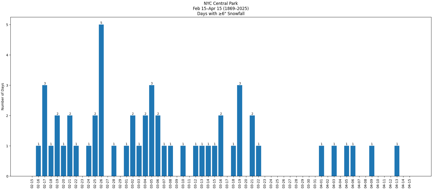
Negativity bias is real. People often assume that their "crystal ball" is clearer at longer lead times when adverse outcomes (e.g., lack of snowfall) are involved. Psychologically, people tend to give greater weight to negative outcomes than positive ones. Those threats appear clearer or more certain, because they generate stronger cognitive or emotional reaction. In reality, the extended range forecasts showing a bleak outcome for snowfall are no more or less likely to verify than those that show a lot of snowfall at similar ranges. Guidance beyond 10 days has a sharp falloff in skill. Having said that, the frequency of days with significant (6" or above) snowfall declines in New York City, especially after mid-March. Moreover, just over one-in-four years (26.8%) saw no measurable snowfall during February 15-28 but only 3.1% of years (1878, 1925, 2002, 2012, 2020) saw no measurable snowfall from February 15 to the end of snow season. At the current lead time, it is premature to assume that Winter 2025-2026 has seen its last measurable snowfall.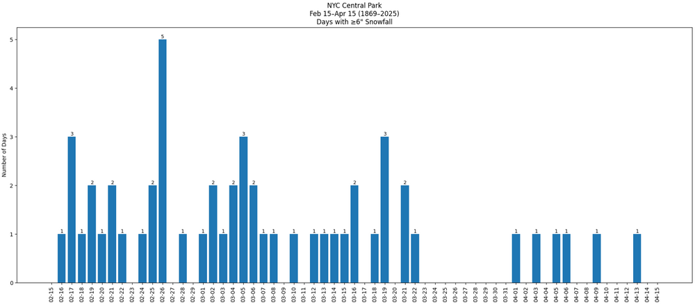
-

Central PA Winter 25/26 Discussion and Obs
pasnownut replied to MAG5035's topic in Upstate New York/Pennsylvania
Hi all. Hope you had a good weekend. Next weekend looks tricky, but I remind some that only a few days ago this week looked warm, and we're now down to a 1ish day "warmup". Nooner CMC is what dreams are made of. Verbatim its a best case scenario, and not sure I believe, but really nice to look at. Antecedent cold is there but as NAO is on the rise, so will be the thermal boundary, so the souther secondary is the way to the white promise land, as critical layers recover and we lose less cold. At least we are pulling off another solid week of winter. -

February 2026 Medium/ Long Range Discussion: 150K Salary Needed to Post
jayyy replied to Weather Will's topic in Mid Atlantic
Canadian threads the needle. Barely -
 Yes!! Lol
 -
Is we back? February discussion thread
40/70 Benchmark replied to mahk_webstah's topic in New England
GEFS and EPS actually in good agreement just outside of BM. -

February 2026 Medium/ Long Range Discussion: 150K Salary Needed to Post
Ji replied to Weather Will's topic in Mid Atlantic
CMC is best case scenario....but its also the CMC. If the euro shifts south like it should based on ensembles...could be interesting -
Is we back? February discussion thread
40/70 Benchmark replied to mahk_webstah's topic in New England
EURO OP went to shit with rain....EPS still outside BM. -
Got woken up at 230am with a brutal migraine and ended up calling out of work (Thankfully non-operational shift). Is anyone else having headaches recently? I think the dryness is starting to crush my sinuses and hits at night. Might have to start back up a saline rinse regimine
-
12Z Canadian strong blocking - models are beginning to agree that this won't cut
-

Pittsburgh/Western PA WINTER ‘25/‘26
colonel717 replied to Burghblizz's topic in Upstate New York/Pennsylvania
NWS has a possible freezing rain to rain scenario as of now. Temps in the upper 30s Sunday. I was on the verge of giving up for the weekend... but latest CMC has almost perfect scenario for us. Its going to require a perfect track. -

February 2026 Medium/ Long Range Discussion: 150K Salary Needed to Post
TSSN+ replied to Weather Will's topic in Mid Atlantic
Random ripper on the cmc. Low cuts to Ohio but transfers fast enough to keep us mostly snow. -

Feb 10-11 Mid Week Minor Event - Ride the hot hand?
CoastalWx replied to HoarfrostHubb's topic in New England
I’m not sure his logic applies here. I guess if Reggie has a clue and it somehow shoots a ton of moisture in here, but in general that low track doesn’t argue for an overachiever. Ratios look decent though. -
Thump to rain on the GFS.
-
Very cold low of -12.3 this morning. Second coldest low so far this season (few weeks ago it was -16.8).
-

Feb 10-11 Mid Week Minor Event - Ride the hot hand?
Damage In Tolland replied to HoarfrostHubb's topic in New England
I couldn’t care less about jacks. Just looking for 1-3 -
Sometimes you just need to look at the big picture, and you can use this gfs run as an example. You have a short wave approaching with low pressure approaching the Carolinas, but look at that bulge of warm air and ridging to the west. You’re also losing the high to the east. So all around you’re getting warm air advection pretty much surrounding this low and that short wave now is starting to attenuate because of that push-up warmth behind it. This is what I mean by not being in a good set up. Could it work, I guess if you really thread a needle, but all I’m trying to do is have people at least understand that this might not work out.
-
I was in Salisbury on Saturday night between 6pm and 11pm or so and they clearly had some decent accumulation but how they ever got an accurate measurement is beyond me. The wind was blowing pretty good and snow was drifting across the road all going out to sea. There were a few driveways that were untouched where you could see a good 6"-10" or so via the tire tracks of cars pulling in or out. No real problems getting around but the local DPW was definitely going to need to hit those drifts periodically.
-
Not sure what you want. You have other members including Mets talking about the Monday setup and moderation. I never said snow is impossible, I said the setup is tough and rain is a viable option.


.thumb.JPG.418e8a9a2902ae687ec35ff4bc0e038e.JPG)
