All Activity
- Past hour
-
.thumb.jpg.6a4895b2a43f87359e4e7d04a6fa0d14.jpg)
Central PA Summer 2026 Discussion/Obs Thread
Yardstickgozinya replied to Voyager's topic in Upstate New York/Pennsylvania
For anybody who doesn't know, colombia and an area of the river that is infamous for its mayflies, they've been turning off the lights of the route thirty bridge since twenty fifteen in response to several accidents, and even small pile ups that occurred due to mayfly hatches. The picture I included I found online, probably from a few years ago, before they turned off, the lights prior to may fly hatches.
-
91 at 4:30 is no big deal. AQI compared to 50 years ago averages in July is also no big deal.
-

July 2026 General Discussion
SchaumburgStormer replied to Chicago Storm's topic in Lakes/Ohio Valley
12 drops out here as they fired overhead and quickly moved east -
Central PA Summer 2026 Discussion/Obs Thread
Yardstickgozinya replied to Voyager's topic in Upstate New York/Pennsylvania
For anybody who doesn't know, the Colombia and Wrightsville area of the Susquehanna river is infamous for its mayflies hatch. The municipality has been turning off the lights of the route thirty bridge since 2015 in response to several accidents, and small pile ups that occurred due to mayfly hatches . -
Big time storms moving in.
-

Saturday, July 18, 2026 Thunderstorm/Severe Weather Potential
CoastalWx replied to weatherwiz's topic in New England
WF action along it. Definitely good shear in place too. Probably pike south deal. Evening stuff maybe best in western areas. -
Saturday, July 18, 2026 Thunderstorm/Severe Weather Potential
CoastalWx replied to weatherwiz's topic in New England
Locking in Southbury to Seymour for that. -

2026-2027 Super El Nino
michsnowfreak replied to Stormchaserchuck1's topic in Weather Forecasting and Discussion
Interesting to see a map of 1877-78. I knew the core of warmth was in the upper midwest, because while it was certainly a mild winter at Detroit, it wasnt nearly as extreme as in Minneapolis. Ive mentioned it before, but the 1875-1882 period had a very odd "every other year" pattern locally of very cold winter followed by very mild winter. 1875-76, 1877-78, 1879-80 & 1881-82 were all warm winters overall. I have no idea how ENSO played into it outside of 1877-78. 1877-78 at Detroit (using present-day departures): Nov: 39.2F (-2.0F)....Snow 1.0" (-0.9") Dec: 38.1F (+6.8F)....Snow 1.9" (-7.0") Jan: 27.3F (+1.5F)….Snow 23.1” (+9.1”) Feb: 29.2F (+1.2F)….Snow 17.4” (+4.9”) Mar: 41.3F (+4.1F)…Snow M (est 1-2")) Apr: 53.4F (+4.5F)…Snow 0 (-1.5”) Huge storm Jan 31st (14.8"). The winter followed a somewhat similar path as other strong Ninos in that there were some very good winter blasts but the warmth won out. And realistically, thats the best formula to run a strong Nino in the north. You want that roller coaster up and down, helps with some good storms and assures you get some arctic blasts with the warm spells. Way better than mundane, stagnant 40s every day. -

2026-2027 Super El Nino
LakePaste25 replied to Stormchaserchuck1's topic in Weather Forecasting and Discussion
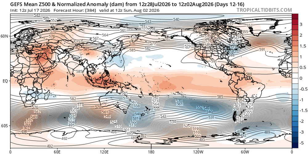
They exist on Tropical Tidbits, but they’re smoothed 5 day means. World view.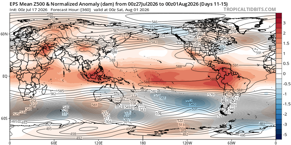
-

2026-2027 Super El Nino
jaxjagman replied to Stormchaserchuck1's topic in Weather Forecasting and Discussion
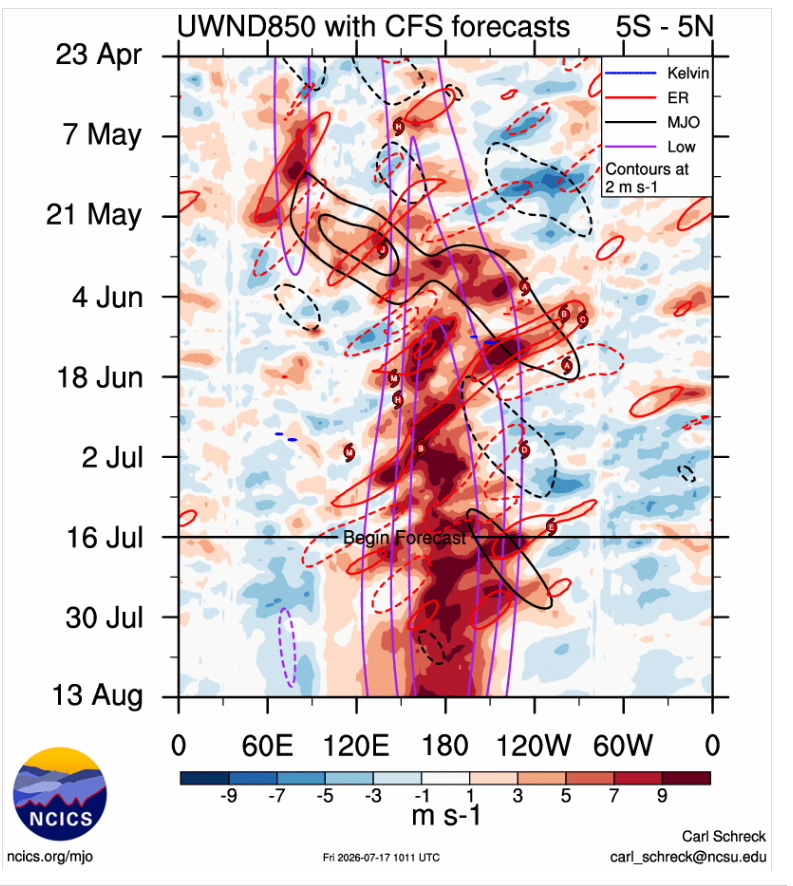
Thats not going to ever happen with the EWB off SA.These winds are killing KW from getting that far east and the MJO should go back into the WP,if anything you might see an expansion from downwelling but 10-12/Not going to happen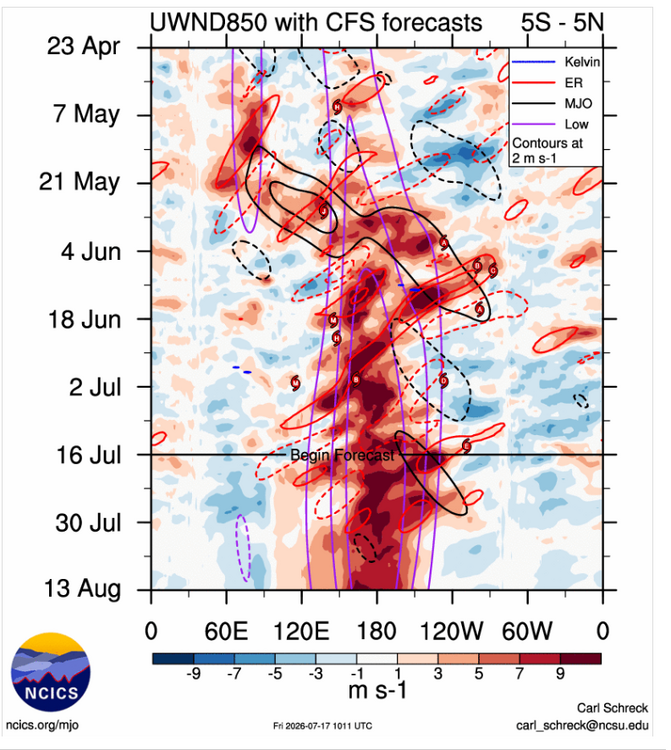
-

2026 Atlantic Hurricane Season
WxWatcher007 replied to Stormchaserchuck1's topic in Tropical Headquarters
Yep, totally agree. This will take some time if there’s going to be a true effort at TC genesis. The overall track and time over the Gulf is all important here IMO. -
I don't know about vanished. I just drove into Tysons and it still pretty gross. AQIs are hovering around 200 in the western Beltway area.
-
...Ohio Valley/Lower Great Lakes into the Mid-Atlantic/Northeast... An active severe-weather day is expected Saturday from parts of the Ohio Valley and Lower Great Lakes into the Mid-Atlantic, as scattered to widespread storms move through an increasingly favorable environment. A 45% wind area has been added, resulting in a categorical upgrade to Level-3/Enhanced Risk. The Enhanced Risk area is a combination of multiple regimes which may eventually overlap, with some areas potentially seeing multiple rounds of strong to severe storms. A mid/upper-level shortwave trough is forecast to move across the northern Great Lakes vicinity through the day, before approaching New England by evening. In conjunction with this shortwave trough, a deepening surface low is expected to move across southern Quebec toward northern Maine, as a trailing cold front moves through the Great Lakes and eventually parts of the Mid Atlantic and Northeast. A remnant surface front initially draped from southern NJ into western PA will lift northeastward as an effective warm front, in advance of the surface low and cold front. As strengthening deep-layer wind fields overspread increasingly rich moisture, a broad region from the Ohio Valley and Lower Great Lakes into the Mid-Atlantic and parts of the Northeast will become supportive of organized convection and severe-thunderstorm potential. HRRR-based forecasts suggest that smoke will become less prominent from west to east by afternoon, which should allow for relatively strong diurnal heating and moderate destabilization in areas not affected by early-day convection. Effective shear of 35-45 kt will support organized clusters and possibly occasional supercells from the Lower Great Lakes into the northern Mid-Atlantic and Northeast, while strong heating and steep low-level lapse rates will result in a favorable wind-damage environment within the somewhat weaker flow regime across the southern Mid-Atlantic and parts of the Carolinas. Elevated convection may be ongoing or else develop during the morning across parts of PA/NY, within a warm-advection regime associated with the returning warm front. Depending on the timing of this convection and downstream heating/destabilization, some intensification of ongoing convection may occur by early afternoon. Additional development may occur along the southwest flank of early-day convection and related outflow, which may intensify and move across the northern Mid-Atlantic during the afternoon. In addition to a wind-damage threat, some hail and tornado potential may also evolve with any supercell development, given the presence of favorable effective SRH. Farther north, a broken band of storms is expected to develop along the cold front and move across the Lower Great Lakes region, eventually reaching a larger part of OH/PA/NY by late afternoon or early evening. Additional storms may develop ahead of the frontal convection, depending on the extent of heating in the wake of early-day storms. Multiple wind-damage swaths may accompany this convection, along with some potential for isolated hail. Rich moisture and some enhancement to low-level SRH may also support a tornado threat with any discrete or embedded supercells, especially near the effective warm frontal zone or any remnant outflow boundaries from morning convection. An initially separate regime of storm development and severe potential is expected to develop along/east of a surface trough across parts of the southern Mid-Atlantic into NC. While deep-layer flow will tend to weaken with somewhat southward extent, strong heating and steepening of low-level lapse rates will provide a favorable thermodynamic environment for downbursts and damaging outflow winds. Depending on the extent of outflow from prefrontal storms, frontal convection may continue to pose at least an isolated severe threat through the evening as it spreads southeastward. Storm Prediction Center Jul 17, 2026 1730 UTC Day 2 Convective Outlook
-

Saturday, July 18, 2026 Thunderstorm/Severe Weather Potential
weatherwiz replied to weatherwiz's topic in New England
yeah certainly could see some flash flooding -
Central PA Summer 2026 Discussion/Obs Thread
Yardstickgozinya replied to Voyager's topic in Upstate New York/Pennsylvania
It took a couple stills from my videos from last night.I was adjacent to the Point rock tunnel in Colombia Pa. The route 30 bridge as only a few hundred yards in front of me, you can just make it out If you look closely. Between the mayflies and the smoke, you couldn't even see vehicle lights for more than a few hundred feet.

-
Saturday, July 18, 2026 Thunderstorm/Severe Weather Potential
WxWatcher007 replied to weatherwiz's topic in New England
Might be some flood risk if those storms train in CT. -

2026-2027 Super El Nino
Stormchaserchuck1 replied to Stormchaserchuck1's topic in Weather Forecasting and Discussion
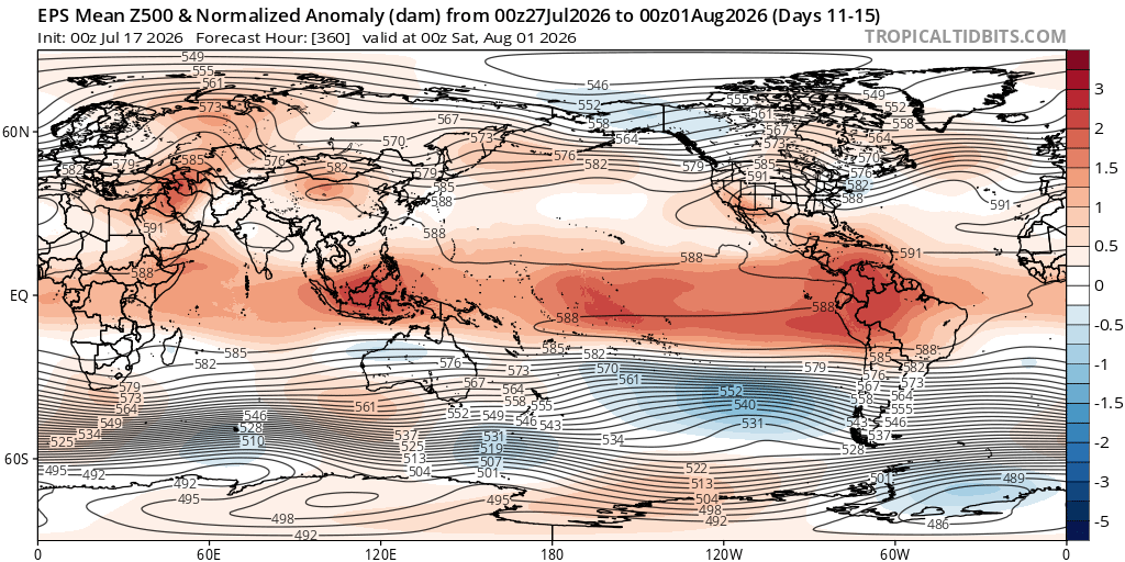
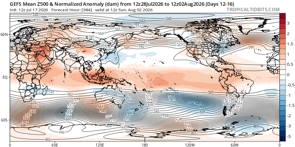
It looks like that Southern Hemisphere version of PNA is coming along pretty nice. TT only has 2m, if someone has global 500mb anomaly for GEFS and EPS can you post the link? 384hr 12z GEFS -

Saturday, July 18, 2026 Thunderstorm/Severe Weather Potential
Cyclone-68 replied to weatherwiz's topic in New England
Not hatched but a 5% tornado threat in NYS -
Is the 2011 tornado damage still visible across the street in the woods?
-
Just can't seem to get the storms around my area for some reason. There have been storms around daily for a couple of weeks now, but I've really had very little rain. And WAY less thunder than a normal July. This should be the wettest month of the year here. Even today we are stuck under the anvil of the large storm cluster over northern Atlanta. It's stabilizing us without giving us any rain.
-
Saturday, July 18, 2026 Thunderstorm/Severe Weather Potential
weatherwiz replied to weatherwiz's topic in New England
To our west but also within CT along the warm front during the afternoon with potential for supercells/isolated tornado risk. Then a line moving through during the evening with localized wind damage threat -
Yeah saw that. I was wondering if that small storm was going to start training but it just went poof over Caroline/Dorchester. The small storm did seem to be associated with the leading line of the smoke moving south east last night.
-

Saturday, July 18, 2026 Thunderstorm/Severe Weather Potential
Modfan2 replied to weatherwiz's topic in New England
For who? -

2026 Atlantic Hurricane Season
vortex95 replied to Stormchaserchuck1's topic in Tropical Headquarters
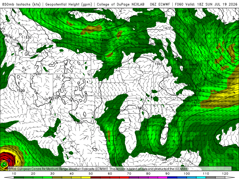
Looking at the ECMWF fcst, it remains cold core aloft for the next several days (see 700 temp 48 hr fcst attached), and at 850 elongated N-S w/ a broad wind field (see 850 winds 60 hr fcst attached). Not much sfc low reflection. I think they may be a case that aloft it is and will stay impressive w/ lots of deep convection/decent swirl, but low-levels struggle to organize. We've seen this before and it looks great on satellite, and some ppl are going, "I can't believe NHC has not declared this yet!" But sfc observations and microwave data show a low-level center ill-defined and/or not tight.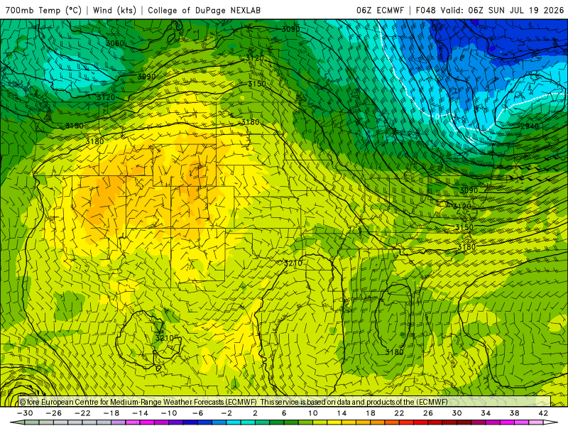
-
Hey Rockingham county, could you share your storms? Thanks