All Activity
- Past hour
-
Looks like across Maryland and south snow began when cloud decks reached around 7,000 ft. Across PA it’s been 4,000ft. Up here it may take til they get down to 2500-3000ft. I’d say it could begin as early as 10Z but meaningful accumulations won’t be til 12-13Z. In these setups too the immediate NYC area as well as western LI always pulls down more dry air from the Connecticut river valley and can take longer to saturate than NW NJ and central and eastern LI
-

“Cory’s in LA! Let’s MECS!” Jan. 24-26 Disco
40/70 Benchmark replied to TheSnowman's topic in New England
Here is my corrected Final map.....like I pointed out earlier, I had a brain-cramp a messed up on the topography of the ORH hills...now have max from the spine at the nw tip of RI/ne CT, right up to KJAF points east to the slopes and into interior ne MA/SE NH. Final Call: -

“Cory’s in LA! Let’s MECS!” Jan. 24-26 Disco
Ginx snewx replied to TheSnowman's topic in New England
Lol this morning I read a tweet from a guy in Tex .He said storm over. Tonight he has no power lol -
Oh Baby. Time to stack the the flakes!!!
-

January 24-26: Miracle or Mirage OBS Thread!
WeatherGeek2025 replied to Jebman's topic in Mid Atlantic
final final snowmap -
Radar really looks fantastic
-
January 2026 regional war/obs/disco thread
WeatherGeek2025 replied to Baroclinic Zone's topic in New England
final final snowmap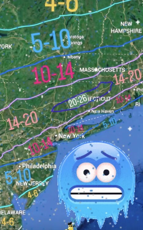
-
.thumb.png.4150b06c63a21f61052e47a612bf1818.png)
“Cory’s in LA! Let’s MECS!” Jan. 24-26 Disco
HIPPYVALLEY replied to TheSnowman's topic in New England
-

January 2026 regional war/obs/disco thread
dendrite replied to Baroclinic Zone's topic in New England
Beer -
Started snowing in Hanover about 20 minutes ago. Steady and light with increasing intensity as the towers atop Pigeon Hills 2.5 miles to my north have faded into the snow. Solid dusting.
-
Extreme Cold, Snow & Sleet: SECS 1/24 - 1/26
WeatherGeek2025 replied to TriPol's topic in New York City Metro

-

Extreme Cold, Snow & Sleet: SECS 1/24 - 1/26
Snowlover11 replied to TriPol's topic in New York City Metro
Faster in, faster out. -
The type of observation we're gonna look back on years from now. So curious as to what the coldest ever sleet observation is, that's gotta be close. 11F with -SN/SN here.
-

January 2026 regional war/obs/disco thread
OrangeCTWX replied to Baroclinic Zone's topic in New England
Miamia Florida with wind chills in the single digits is insane lol -

Southern Crippler - Get well soon Jimbo Storm Obs
85snowline replied to BooneWX's topic in Southeastern States
Still pixie snow with sleet in Concord. -
1/3rd inch since 12 midnight onset . Moderate to heavy rates but small flakes
-

Southern Crippler - Get well soon Jimbo Storm Obs
LakeNormanStormin replied to BooneWX's topic in Southeastern States
Radar keeps telling stories. North Mecklenburg glazing over like Krispy Kreme. Sleet too -
I am getting demolished right now. Amazing!!
-
Apple Weather still has 12-15. Does anyone know what model they could possibly be pulling from?
-
That, was a true Vodka-cold Jebwalk.
-
This has gotta be some of the heaviest sleet I've ever seen. Temp is now down to 7F. Insanity!
-
RRFS held from its previous run showing a general 6-8" across most of the area before the flip
-

“Cory’s in LA! Let’s MECS!” Jan. 24-26 Disco
WinterWolf replied to TheSnowman's topic in New England
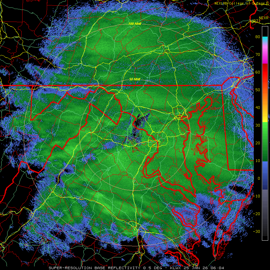
Usually if you see the radar, and it looks good out into PA and down into West Virginia and the Delmarva, we’d be pumped. BUT this thing has a radar that looks great literally back to New Mexico for god sakes, without a break in the precip/snow. Astounding. -

“Cory’s in LA! Let’s MECS!” Jan. 24-26 Disco
ChangeofSeasonsWX replied to TheSnowman's topic in New England
I'm assuming you're talking about strictly synoptics? PVD got barely any snow in Feb 99. -

1/24-1/25 Major Winter Storm - S. IL, IN, and OH
andyhb replied to A-L-E-K's topic in Lakes/Ohio Valley
Looks like Ohio’s biggest storm in quite awhile. Notable banding setting up initially north of Cincinnati right now extending all the way back through S IN and IL.