All Activity
- Past hour
-
-
I mean it’s semantics at the end of the day and they have to cut off somewhere. The main thing is the public is informed either way whether you call it an advisory or warning. An inch or two difference in projection is all that’s different. Never understood why people cared so much about that - if you’re in the borderline of warning vs advisory you clearly know it could go either way.
-

Central PA Winter 25/26 Discussion and Obs
anotherman replied to MAG5035's topic in Upstate New York/Pennsylvania
What an idiot. -
public know that ? and how do you know its going to be only 3 -6 in Somerset County NJ ? Staten Island WSW and Somerset only an advisory ? Read what Roger just posted
-
Because it doesnt mean criteria It a 3-6 inch event for that area.. The storm brunt is 9-4am..most wont be traveling
-
Craig Allen Update #3 A little tweaking to accommodate the models trying to figure out a)where heavier bands may set up b)where warmer air may nose in aloft and result in sleet or freezing rain c)if the 32 degree surface temp makes it up the coast to the South Shore of LI Finer details need to be ironed but I would stick with a general 4-8" for about 75-80% of the area. Heaviest will fall after dark, Friday and tapering off Saturday morning See you at 6 and 11 on CBS New York /2
-

December 2025 regional war/obs/disco thread
moneypitmike replied to Torch Tiger's topic in New England
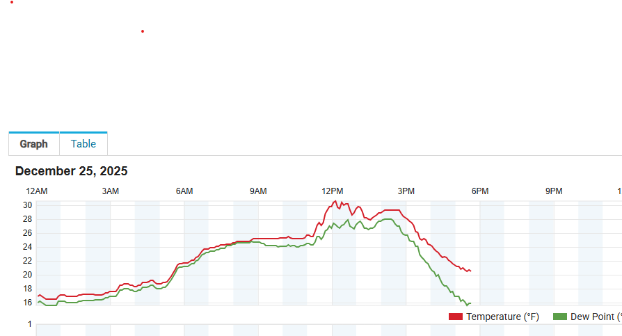
The front passed through here at around noon......accompanied by a period of steady snow. Now down to 20*. -
I think it was a mistake that Mt. Holly lowered its Winter Storm Watch to an Advisory in North Central NJ - for one it sends the wrong message to the public.......many will think the storm is no big deal and start traveling when they should have stayed home....
-
We’re never happy for our NY friends.
-
If it’s snowing, would you care…LOL! Prison is in Kansas, this is in Washington State in the Cascades…if Santa had a love child with Bavaria it would be Leavenworth, Wa. Downtown looks like a Bavarian village, with beer halls and brats on every corner. Heaven?!
-
2/7/94 was insanely mild down in the TN Valley/SE. ATL I believe hit 80 that day...might be closest match but February is a different story than Dec. Its way easier for those places to get that warm in early February than late Dec
-
and the anti 's will say it's wrong lol
-
-
This might be the first time dew points above 60 in KY are recorded on a day before a winter storm hits NYC but those dews are not even going to reach se VA, if the GFS scenario is correct the low that forms takes all day to cross Ohio and is slowly consumed by the attempt to push the cold air back, eventually it just reforms off the southern Delmarva and continues east from there. In this kind of setup I don't see a lot of potential for guidance to bust on the mild side, I think there might be a chance it busts on the cold side further south and sleet mixes for a while in c NJ then it goes back to all snow there too. NYC will be in the vicinity of 534-540 dm thickness during the bulk of the event, often that is rather marginal for temps but I note that right now, the air mass pushing southwest has an average T/Td of 20/10 under that portion of its outflow (approx upper MI across L Huron into sw ON) and the surface feed is even colder from upstate NY so by morning I would not be surprised to find temps in n NJ and NYC metro near or a little below 20 F. And there will be quite limited warming before precip arrives. I bet there will be numerous comments posted tomorrow just before onset along the lines of "it is much colder than I was expecting" and the result will be precip boundaries further southwest than a lot of the guidance is showing. So in other words the bust will be opposite to what a lot of people are expecting the bust to be. Would be comfortable with 5-8 inches generally and 10-15 local banding maxima. There again those bands could be intense further south than some are expecting.
-
No the clock is not ticking. You still have February. Remember the heart of winter is middle of January to the middle of February. As I’ve said many times before. Out of the top 10 snows for TN. The majority have happened in February.
-
-
Your in the Forky camp.
-

26th-27th event, coming at us like a wounded duck.
moneypitmike replied to Go Kart Mozart's topic in New England
The only issue with this is that you have my new digs in the 1-2 range. Might want to reassess that part. -
How do various current wx station models handle normally-varying wind directions? Do any update the direction display many times per second? Many models display what the wind direction happened to be when that instrument was last queried. As most here probably know, air does not always move in a straight line. A real-time wind vane will show the direction changing frequently, for example, anything from W to N, or even beyond, when the average direction is NW. To learn, I acquired a low-end station because the maker was practically giving them away. When I know the predominant direction to be NW, this unit sometimes displays S or E or others because the wind happened to swirl a bit when the vane was last queried. A few seconds later, the next query might return a very different direction. It's basically useless for determining the predominant direction. Some better stations quote a 2-second sampling rate, which seems too low to me, perhaps because I am used to a wired, real-time vane.
-

Central PA Winter 25/26 Discussion and Obs
Jns2183 replied to MAG5035's topic in Upstate New York/Pennsylvania
Latest prediction is for about 0.3-0.5" of sleet and 0.15 of freezing rain for Harrisburg Cold front has past, skies have cleared and a breezy north wind is pushing cold air in Sent from my SM-S731U using Tapatalk -
I ended up acquiring replacement parts from d8apro.com and repairing the unit.
-

December 2025 regional war/obs/disco thread
HoarfrostHubb replied to Torch Tiger's topic in New England
Yeah the winds (and temp drop) is noticeable. -
Here is another nugget from the 18z ICON. It isn't a December map, but extrapolate...LOL. addendum: The way that run looked. It had the PNA locked into the West w/ the AO and NAO negative. If the GFS can back its trough up just a little, it gets here IMHO. At 18z it isn't there, but it trended that way again at 500.
-
I still think NYC ends up with a solid period of sleet with this. We're seeing the typical correction back south now we often see at this range but then inside the final 18-24 ticks back to the N tend to occur once again and sometimes verification still ends up even further N by 15-20 miles on what your game time start guidance has. There will likely be 2 big time areas who get smashed here. One will be the typical just NE of the changeover which might run from like CNTRL LI NW up through Fairfield Co and roughly SWF/POU. The 2nd will be a frontogenesis/dry air subsidence induced area somewhere in ERN CT probably up into SRN-CNTRL MASS. Overall the good news is the 3K does not agree with the 12K but given where the RGEM has been consistently and the 3K at 18Z I like a 30 or so mile shift to the NE on this roughly. I am in Flagstaff so I'll be missing the whole thing.
-

E PA/NJ/DE Winter 2025-26 Obs/Discussion
KamuSnow replied to LVblizzard's topic in Philadelphia Region
Merry Christmas! 47F here. We shall see about tomorrow, looking like not a lot of snow down here, but an inch of sleet will make the ground white at least!


