All Activity
- Past hour
-
OK this can be deleted now...a rare glitch, this site is very stable. Thanks!
-
The wetlands in our area are key ecosystems. While we lost large swaths to development from Jamaica Bay out to Eastern LI, at least what we have now has been designated as preserves. Imagine seeing the whole area from NYC out to Long Island hundreds of years ago. NY Harbor back to the NJ Meadowlands was one of the greatest natural estuaries in all of North America. Jamaica Bay wildlife refuge is still one of the most important stopovers for migrating shorebirds in the East. Before the 5 towns was developed it was called the Woodmere Woods. That was an extensive forested area which people fought to save before it got developed in the mid 1900s. Much of Central Nassau was called the Hempstead Plains natural grasslands. Only a small portion of the original habitat survives near Nassau Community College. The back bays from Nassau to across the GSB still have a large mash habitat. The further east you go on Long Island the closer you get to something that is close to the original state. Especially from the Pine Barrens out to the Twin Forks.
-
No, you had something else to complain about that was more important at the time
-
The demise of Fsll has been greatly exaggerated.
-

Spooky Season (October Disco Thread)
Damage In Tolland replied to Prismshine Productions's topic in New England
These are all in the ground . The only issue they’re right in the path of leaf blowing and I had to tiptoe around them on Saturday . Imma give them another week or so and see if anything blooms into fruit and if not , I’ll yank them . But I get no freeze here till early- mid Nov -

Spooky Season (October Disco Thread)
ma blizzard replied to Prismshine Productions's topic in New England
Thats incredible .. most of my plants got nuked when it hit 29 on the 10th. Still got some beefsteak and roma tomatoes going strong that were planted in the ground though! 2 years ago had peppers, tomatoes, eggplants, etc go strong til 11/1! -

2025-2026 Fall/Winter Mountain Thread
Sw NC weather replied to Buckethead's topic in Southeastern States
Had 35 and a frost in cowee this morning. First of the year - Today
-
Temperatures will top out in the lower and middle 60s through midweek. A stronger push of cold air could arrive afterward. Cool temperatures will likely persist through next weekend. The ENSO Region 1+2 anomaly was -0.4°C and the Region 3.4 anomaly was -0.6°C for the week centered around October 15. For the past six weeks, the ENSO Region 1+2 anomaly has averaged -0.15°C and the ENSO Region 3.4 anomaly has averaged -0.47°C. La Niña conditions will likely continue through mid-winter. The SOI was +7.60 today. The preliminary Arctic Oscillation (AO) was -1.132 today. Based on sensitivity analysis applied to the latest guidance, there is an implied 67% probability that New York City will have a warmer than normal October (1991-2020 normal). October will likely finish with a mean temperature near 58.6° (0.7° above normal). Supplemental Information: The projected mean would be 1.7° above the 1981-2010 normal monthly value.
-
My high school was built on it and is sinking a few inches every decade lol. They are havens for mosquitoes and other awful biting insects. I think if we exterminated mosquitoes and these other biting flies from the planet no one would ever miss them. Aside from draining the swamps, what else can be done? Spraying of pesticides? But that has its own issues.
-
Wetlands are, but not the ones in our area (especially not the ones near where people live).
-

Spooky Season (October Disco Thread)
HoarfrostHubb replied to Prismshine Productions's topic in New England
Local PWS is at 0.99” for the day. I need a hundredth. -

Monday, October 20, 2025 Squall Line Potential
Baroclinic Zone replied to weatherwiz's topic in New England
Solid dousing of rain -
Spooky Season (October Disco Thread)
Damage In Tolland replied to Prismshine Productions's topic in New England
I picked 3 medium sized bell peppers, 1 banana pepper, a handful of cherry tomatoes and 3 regular tomatoes today. Still some green ones left on the vines and flowers blooming. The lack of sun probably prevents much new growth . But with zero cold anywhere in sight.. summer marches on . -
The wetlands are some of the most important ecosystems on the entire planet.
-

Spooky Season (October Disco Thread)
BrianW replied to Prismshine Productions's topic in New England
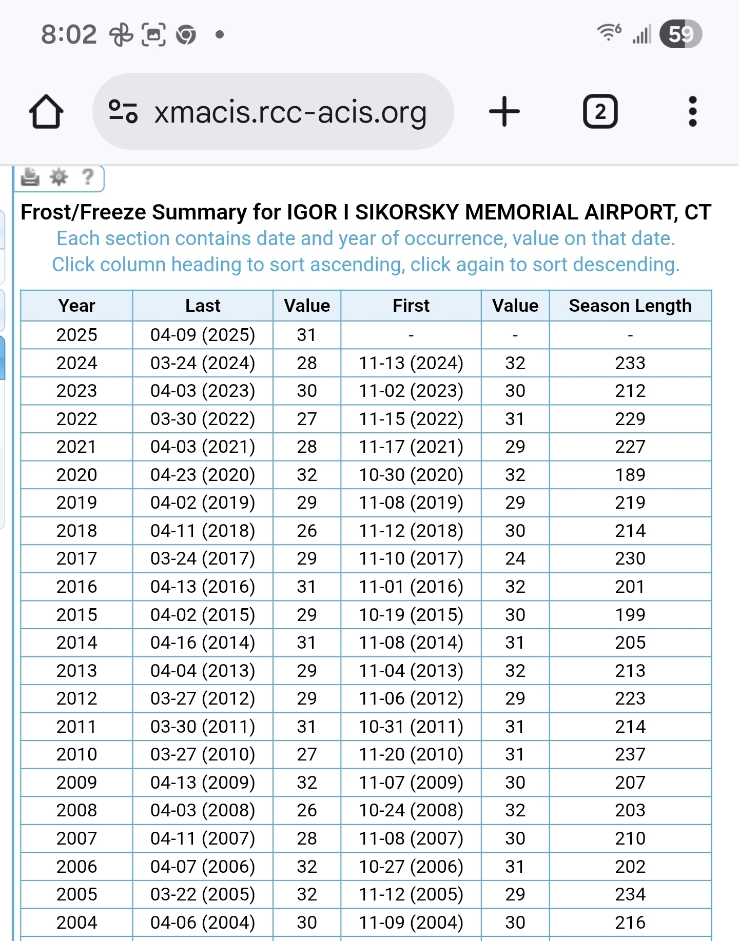
Still haven't even been in the 30's here. Looks like another mid November or later first frost for BDR.
.thumb.png.6a379899890f8c538c6a60dc09b8ee66.png)
-
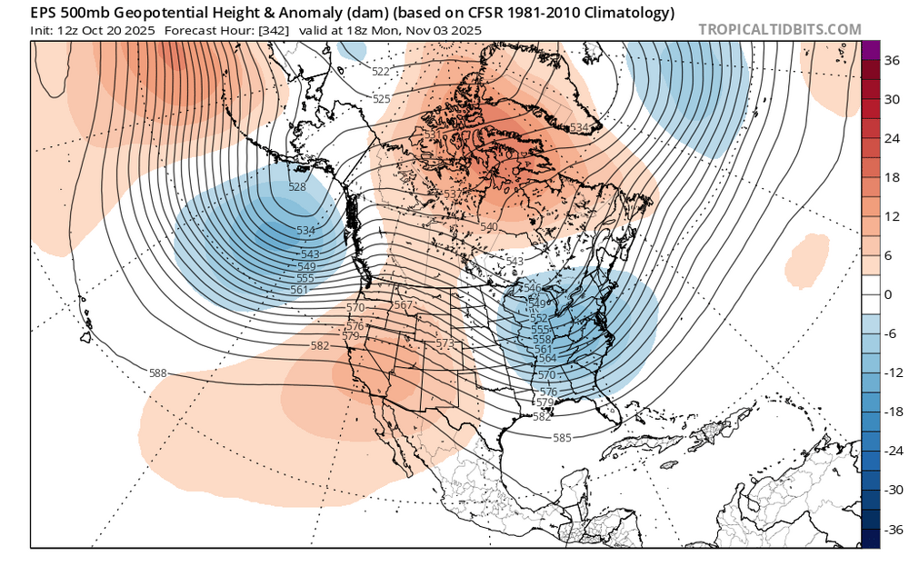
a little surprised by this because it’s more of a strong-storm induced cooler airmass, not canadian-sourced arctic air
-
It's 91/66 an sure enough I am outside clearing brush like a common inmate such as Cool Hand Luke, except I am not very cool, and it is sure not cool outside. Hell goes on in south Texas. Us getting down to average lows like 57 degrees is a RARITY. We are averaging 10-13 degrees ABOVE avg for lows. No end in sight, it will continue hot and humid likely right into November, and absolutely no RAIN for the foreseeable future. Fuels such as grass and scrub are drier than a proverbial popcorn fart. One spark and the entire state goes up and me with it. What a relief! I can't work in this hot dry torrid environment. This part of the world is CURSED. No doubt about it. Its deep Autumn everywhere but south Central Texas where HELL SUMMER reigns supreme. That subtropical high is made of steel and all other weather systems just bounce off it. Its the Ultimate Klingon Anti Rain and Anti Cold Front Shield.
-
Climo wins again. Models were suggesting no frost here until November but we'd never made it past October 20th in the last 60 years. Sure enough, 34 and a heavy frost this morning.
-
Marshes prevent flooding and are home to many important species. They should be tearing houses down that were built on them, not the other way around.
-
Recorded only .01” What a tremendous bust.
-

Spooky Season (October Disco Thread)
CT Rain replied to Prismshine Productions's topic in New England
Euro drops like 20" of rain in DC lol -
One thing I noticed when it's extremely hot and dry, the mosquitos hide in the shade and come out much later in the day just before the sun sets. Or they come out when you're watering your plants lol.
-
Marshes are awful, it's why we call them swamps. I'm hoping one of these days they'll chop down the tall grass and get rid of this excess water. There are tsetse flies in there (they cause sleeping sickness). 42 inches sounds right around what I'd expect for rainfall. I always thought a more tropical climate begins with around 50 inches of rain, like what the Gulf Coast receives.
-
Natural Gas Futures Surging as Weather Models Shift Dramatically Colder Daily Gas Price Index Markets Report Natural Gas Prices Having trended substantially colder over the weekend, weather forecasts were in the driver’s seat Monday morning as natural gas futures mounted substantial early gains. ———— This is referring to colder 2 week forecasts, which is typically what NG reacts mainly to. They don’t normally react in a substantial way to updated winter forecasts.
-
Up to .86”. We might be able to squeeze out an inch.


.png.f39fbc45797b2e4e2027a2e88f891c82.png)