All Activity
- Past hour
-
Is there anything more exciting than frost on the car in May?
-

E PA/NJ/DE Spring 2026 Obs/Discussion
Mikeymac5306 replied to PhiEaglesfan712's topic in Philadelphia Region
Had to turn the heat back on this morning for a bit. -

Central PA Spring 2026 Discussion/Obs Thread
Mount Joy Snowman replied to Voyager's topic in Upstate New York/Pennsylvania
38 when I left the house and 36 through the rurals. Not shabby for mid May. Looks like it won’t be long before we have some sustained warmth. -
@Ginx snewx

-
That would be fine with me. It's the earliest Memorial Day possible this year. So, with almost a full week of May left after the Monday holiday, it won't really feel like the start of summer anyway.
-
So looking forward to the heat this weekend and next week . We are almost to summer now
-
May 12 1922: A strong cold front moves through western Minnesota, replacing shorts with sweaters at Morris. The temperature dropped from 91 to 26 on this date. For Tuesday, May 12, 2026 1934 - A dust storm darkened skies from Oklahoma to the Atlantic coast. (David Ludlum) 1971 - Dust storms suddenly reduced visibilities to near zero on Interstate Highway 10 near Casa Grande AZ. Chain reaction accidents involving cars and trucks resulted, killing seven persons. (The Weather Channel) 1972 - In Texas, A cloudburst dumped sixteen inches of rain north of New Braunfels sending a thirty foot wall of water down Blueders Creek into the Comal and Guadalupe Rivers washing away people, houses and automobiles. The flood claimed 18 lives and caused more than twenty million dollars damage. (The Weather Channel) 1982 - A late season snowstorm struck the Front Range of the Colorado Rockies. The storm produced 46 inches of snow at Coal Creek Canyon, located near Boulder. (David Ludlum) 1987 - A heat wave persisted in central California. Afternoon highs of 100 degrees at Fresno CA and 102 degrees at Sacramento CA were records for the date. (The National Weather Summary) 1988 - Unseasonably warm weather prevailed in the western U.S. Eight cities reported record high temperatures for the date, including Pendleton OR with a high of 92 degrees and Phoenix AZ with a reading of 106 degrees. (The National Weather Summary) 1989 - Showers and thunderstorms associated with a low pressure system stalled over New York State drenched Portland ME with 4.50 inches of rain in 24 hours. Rains of 5 to 7 inches soaked the state of Maine over a four day period causing 1.3 million dollars damage. (The National Weather Summary) (Storm Data) 1990 - Thunderstorms produced severe weather from eastern Texas and the Central Gulf Coast States into Missouri and Illinois. Thunderstorms spawned six tornadoes, including one which injured four persons at Doloroso MS. Thunderstorms also produced hail three inches in diameter west of Vicksburg MS, and wind gusts to 83 mph in southern Illinois, north of Vevay Park and at the Coles County Airport. High winds and heavy rain caused 1.6 million dollars crop damage in Calhoun County IL, and in southeastern Louisiana, Saint Joseph was deluged with eight inches of rain. (The National Weather Summary) (Storm Data)
-
Rain chances Wednesday (90% NWS yesterday) have completely evaporated. Yet another system drying up east of mountains. I said 1” for the month was a lock but have definitely jinxed it in Raleigh area, it looks dry as a bone going forward!
-

Central PA Spring 2026 Discussion/Obs Thread
Superstorm replied to Voyager's topic in Upstate New York/Pennsylvania
39F for low in Lancaster. Last 30s for a while? . -
T-stms this morning with hail. Sounded like rocks hitting the house. Up to pea size. mPing has some reports up to 0.75 to my SW. Nature's alarm clock 0500.
-
Take for what ?
-
Would be fitting that we finally get our rainy pattern to start on Memorial Day weekend. But overnight euro sorta followed the pattern of the gfs and a Bermuda high combined with a stalled front could be a winning combo.
-
36F here for the low; glad we haven’t installed yet
-
Patchy frost on the grass and car windows frozen over.. we take!
- Today
-

Central PA Spring 2026 Discussion/Obs Thread
mahantango#1 replied to Voyager's topic in Upstate New York/Pennsylvania
31.6 this morning with frost and ice on the vehicles. This upcoming warmup can't get here soon enough. Covering up plants to protect them from frost is starting to get old. -
Not sure how I’d handle a dry, warm Saturday.
-
Central PA Spring 2026 Discussion/Obs Thread
mahantango#1 replied to Voyager's topic in Upstate New York/Pennsylvania
Your going to Alaska, right? Maybe you should seek a residence there to escape most of the heat. Anyway It might not be that hot here this summer. -
Central PA Spring 2026 Discussion/Obs Thread
mahantango#1 replied to Voyager's topic in Upstate New York/Pennsylvania
Bring on the heat! -
Looks like a decent soaker here later tomorrow until Friday morning. Seems like it mostly ends by late Friday morning here.
-
Min 36.1° Thankfully not close to a freeze
-
37F. This Springs blows so far. Sent from my SM-S921U using Tapatalk
-
Point and click for PIT is 90 on Monday. This would be the earliest 90 degree day in the season since 1993. Also, the record high for May at the airport site is 91 (all of the days that got above 91 were observed elsewhere). So if PIT can break or tie that record, it would be the second month this spring with a monthly record high at the airport site.
-

Central PA Spring 2026 Discussion/Obs Thread
Voyager replied to Voyager's topic in Upstate New York/Pennsylvania
Well, this escalated quickly! Saturday Mostly sunny, with a high near 77. Saturday Night Partly cloudy, with a low around 55. Sunday Sunny, with a high near 82. Sunday Night Partly cloudy, with a low around 56. Monday Mostly sunny, with a high near 87. -
Caught this chubby looking hummingbird earlier just camping out at the feeder pondering the many mysteries of bipolar spring weather in New England. (Apologies for the background glare, I gotta fix that in the future)

-

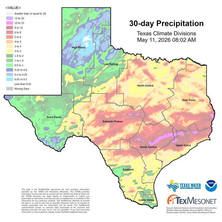
Texas 2026 Discussion/Observations
Stx_Thunder replied to Stx_Thunder's topic in Central/Western States
Water has indeed been piling up within the past few weeks. And definitely does not appear to be over, with storms (and attendant svr risk) likely to return next week (17th).