All Activity
- Past hour
-
Hmmm. Timely article I just read adds another data point...... https://www.cnn.com/2025/11/19/weather/polar-vortex-cold-snowy-december-stratosphere
-
I am an outstanding forecaster as the same areas continue to get drowned by heavy rain and Austin remains drier than a proverbial popcorn fart. That Curl Pattern always leaves Austin out to dry. At this time I expect approximately one sixteenth of an inch as the front goes by eventually. Farther west torrential rain continues, provoking more flooding.
-

November 2025 general discussions and probable topic derailings ...
Kitz Craver replied to Typhoon Tip's topic in New England
It would be really nice to avoid the default holiday screamer this season, we can hope. -
 Sometimes it’s hard to resist the temptation and You can’t help yourself .. from falling….
 -

November 2025 general discussions and probable topic derailings ...
IrishRob17 replied to Typhoon Tip's topic in New England
I think you threw one of those lyrics out there last week too and I waited for one of the locals to respond but I believed it was crickets on that so I went all in this time...I like living on the edge... -
Frost was everywhere this morning here.
-
 the PV closer to us has been perturbed already. seems like this should couple pretty well
-

November 2025 general discussions and probable topic derailings ...
weatherwiz replied to Typhoon Tip's topic in New England
even mesos are a mess for us, yes but I am looking at more of the region as a whole (including just to our south. I would have to think any north guidance with the heavier axis is wrong but we do get some increasing diffluence aloft late with PVA so we may see showers blossom (just not heavy rain...maybe coast gets heavier rain). -
Only the GFS has soaking rain. It’s not hard at all. A shower or very light rain and call it a wrap
-
 Yeah. Night and day on the GFS and Euro.
 -
I actually don’t think that’s coming this year . I think it holds off until January when winter more or less ends . Like mid or maybe latter Jan.
-
I knew someone would kick into the verse
-
Could it a cold , dry 1989 type Dec.. could it snow a bit? There’s something happening here.. what it is Wolf ain't exactly clear .
-

November 2025 general discussions and probable topic derailings ...
Lava Rock replied to Typhoon Tip's topic in New England
Aliens -
November 2025 general discussions and probable topic derailings ...
weatherwiz replied to Typhoon Tip's topic in New England
What an absolutely colossal joke guidance is with tomorrow night. Who event wants to forecast precipitation events 4-5 days out? It's been absolutely terrible. I can only wonder how many storms we'll see on guidance 4-5 days out and the snow maps of 8...10...12+ inches start flying out only for significant reductions inside of 48 hours. Or who knows...maybe we'll get some in the other direction where it looks like crap and then we're forecasting 6-10" all of a sudden -

Fall 2025 Medium/Long Range Discussion
Powerball replied to Chicago Storm's topic in Lakes/Ohio Valley
Clippers have to be an endangered species at this point, but it's been that way for a while. I remember them being quite common in the 90s through mid-2000s. -
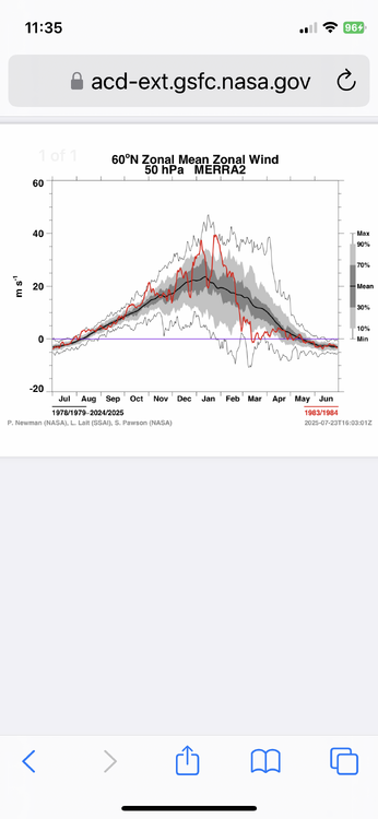
Thanks, Don. One thing helping 2025 vs 1983 is that 1983 didn’t have a weak SPV as it didn’t get <15 m/s through Nov and Dec:
-
28° Moderate Frost
-

Central PA Fall Discussions and Obs
Jns2183 replied to ChescoWx's topic in Upstate New York/Pennsylvania
Homemade egg nog and black Friday snow storm are a 2:1 special Sent from my SM-G970U1 using Tapatalk -
November 2025 general discussions and probable topic derailings ...
weatherwiz replied to Typhoon Tip's topic in New England
There was alot of ice in my freezer this morning too, more than usual. that's because I turned on the ice maker -

December 2025 Short/Medium Range Forecast Thread
Carvers Gap replied to John1122's topic in Tennessee Valley
And you know, I really didn't look closely at the 0z Euro...but it was close to a decent storm on the 29th. It had almost a foot and a half in the Apps. After the Euro nailed this last system, it might carry a bit more weight if it shows the same thing again at 12z. Edit: I must not have looked at overnight model runs carefully enough...the 0z GFS had that as well Model has been empty of systems around Thanksgiving or loaded up. With that strong of a cold front(will it be strong?), one would think a system will be present somewhere in the eastern half of the country. -
I think NYC will eventually see another 4” day. Not sure when though. But the more impressive streak for NYC had been no March 10” daily snows since 1993. It’s possible that the climate has warmed too much for that record to be reached again. 1993-03-13 40 28 34.0 -7.8 31 0 2.37 10.2
-

Central PA Fall Discussions and Obs
canderson replied to ChescoWx's topic in Upstate New York/Pennsylvania
Where do I sign up for the Black Friday snowstorm? -
 Yep. 1st skim ice on the pond i drive by in my town each day. 20F for my low
 -
December 2025 Short/Medium Range Forecast Thread
Carvers Gap replied to John1122's topic in Tennessee Valley
In watching the 12z GFS and ICON rollin in for next Thursday into Friday, I can't help but think there is room for snow in that setup. The ICON has another, albeit weaker, NW flow event modeled. The GFS is close to something for west TN. That front is much strong at 12z than it was at 6z.