All Activity
- Past hour
-
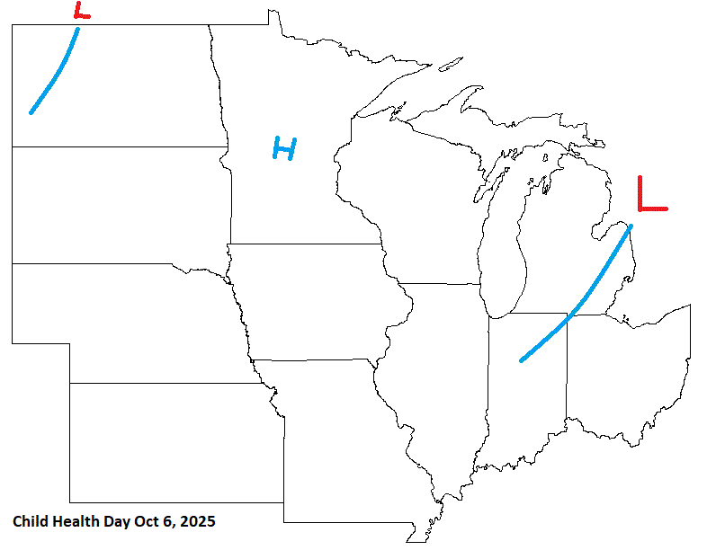
57 this morning. Another beautiful day on tap
-
I disagree that it would have been a snowstorm 20 years ago. It could easily have been several degrees cooler but not nearly cold enough for a snowstorm imho.
-
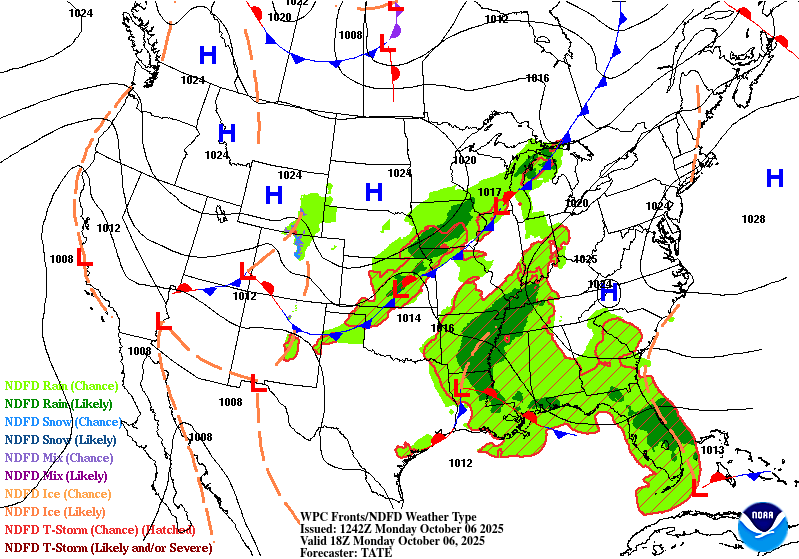
Decent call here. A little quick moving the boundary thru tho.
-

Spooky Season (October Disco Thread)
Damage In Tolland replied to Prismshine Productions's topic in New England
I have doubts how far north it can get with the block up north and trough in the west . Seems like congrats mid atl -
20 years ago it would have been a snowstorm but not in 2025..
-
Hey Charlie, Thanks. I had no idea because I hadn’t checked his source’s (CO2Science) bias rating. I just did my own check and see at the reputable “mediabiasfactcheck” that it’s rated as “low” on factual reporting and “pseudoscience”. It says that it “promotes climate change denial and misinformation”. https://mediabiasfactcheck.com/co2-science-bias-and-credibility/ This, I just posted this to him: I then googled CO2Science, myself, and saw at the reputable “mediabiasfactcheck” that it’s rated as “low” on factual reporting and “pseudoscience”. It says that it “promotes climate change denial and misinformation”. https://mediabiasfactcheck.com/co2-science-bias-and-credibility/ Sorry, but unfortunately this source, just like “Watts Up with That?”, isn’t going to cut it for my use due to bias as mediabiasfactcheck rates it with the same “pseudoscience” rating that it rated Watts with. I appreciate your help though.
-

Spooky Season (October Disco Thread)
Spanks45 replied to Prismshine Productions's topic in New England
If correct, the OBX is going to take another one to the chin after losing 9 homes in the coastal storm/Erin situation....Hopefully what ever forms throws a ton of moisture up this way, after the weekend of course. -
The global numerical guidance have been formulating a mid and upper level vortex along the M/A for several days worth of cycles... It's unclear why they are so deep at the surface, however...when there's only modest at best baroclinic instability below the 700 mb in that region astride the M/A. You need the fuller vertical integration to succeed a sub 990 mb -type powerful cyclone genesis. mmm, so I'm a bit suspect of the Euro/GGEM/GFS as being too amplified. They could be right .. but I also think a 00z UKMET -type solution is more possible. This is based on a couple of concepts. One, modeling tends to too much amplitude beyond D6 as a standard correction ... They'll lose some 20 ... 30% kinematic layout as that time range comes into the D4s. How many times has the d-drip euphoria of the D8 bomb turned into a 4-6" jack in the winter for example. Two, if there's a hybrid lurking in destiny, it would probably have to come from a weaker initial 500 mb closure than the Euro-like solutions are presently selling. It's almost like 'thermodynamic momentum' Pig extra-tropical gyres have a lot of cooler mass/momentum, so it takes longer to modify the kinematics toward a warm profile. If the initial trigger is a weaker mid level instability, the machinery (outflow aloft) from ongoing festering convection instantiates and starts to feedback with inflow into festering convection ... conversion doesn't have as much to overcome. In some rare cases, a stronger initially cold core gyre may transition, provided the surrounding hemisphere is very supportive ( 1990 "perfect storm" scenario). So it's not impossible - but rareness immediately assumes 'less likely' in this case.
-
I’d say in general, we don’t want a cold october as that tends to correlate with milder winters. So if a -NAO causes a colder october in the east, we probably will want to root against it.
-

Spooky Season (October Disco Thread)
SouthCoastMA replied to Prismshine Productions's topic in New England
Shitty timing though. I don't want Columbus Day weekend to be anything but boring. -
I believe you are correct. -NAO in October means it's more likely than not for +NAO in DJF.
-
For the uninitiated like me, that means we do not want a -NAO in October, correct?
-
Just need the rain out quick Wednesday AM in western Howard County. Looks good so far on the guidance.
-

Central PA Fall Discussions and Obs
FPizz replied to ChescoWx's topic in Upstate New York/Pennsylvania
Euro AI is pretty wet as well. -
let it rain!
-
61 / 60 last of the fog burning into C/S NJ Pienbarrens
-

Central PA Fall Discussions and Obs
Superstorm replied to ChescoWx's topic in Upstate New York/Pennsylvania
It does on 0Z Euro . -
My weekend plans are all indoors, bring it on.
-

Spooky Season (October Disco Thread)
WxWatcher007 replied to Prismshine Productions's topic in New England
That signal has been there for a while too, it’s only become more pronounced across guidance this past weekend. Maybe a little hybrid/subtropical with some energy trying to eject out of the Gulf. Track/intensity TBD. Of course, I’m up at WXW2 for the next week if it does come -

Spooky Season (October Disco Thread)
ineedsnow replied to Prismshine Productions's topic in New England
Ya atleast something interesting.. about time the weather has been boring -

Spooky Season (October Disco Thread)
CoastalWx replied to Prismshine Productions's topic in New England
Gfs is a pretty stormy nor’easter later Sunday into Monday. AI euro is too. - Today
-

Central PA Fall Discussions and Obs
pasnownut replied to ChescoWx's topic in Upstate New York/Pennsylvania
saw that. It'd be nice for it to hook a little left and pay us a visit. I'm ready for a cool rainy weekend, so that I can enjoy some non chore time (just got my list pretty much cleaned up yesterday). Bring it. -
Would be a drought busting event. Bring it on.
-
Central PA Fall Discussions and Obs
pasnownut replied to ChescoWx's topic in Upstate New York/Pennsylvania
I know many wanted him gone for years now. I'm not sure thats warranted, but I'm guessing he now knows its time to change some things before he gets walkin papers. Not sure he can do it, but we'll find out soon enough. -

Spooky Season (October Disco Thread)
Snowcrazed71 replied to Prismshine Productions's topic in New England
Seems to be very good consensus that we're getting a half inch to 1 inch of rain statewide on Wednesday. The other thing to note is there. There is a possible system for Sunday that could have tropical elements to it. Still a ways out so that can change, but if it comes up, they're saying there's a possibility that it stalls. Plus though maybe some win with that as well. That we need to keep a close eye on


