All Activity
- Past hour
-

Nov 28-30th Post Turkey Day Wintry Potential
Radtechwxman replied to Chicago Storm's topic in Lakes/Ohio Valley
Yeah unfortunately strong waa always wins out here. My ideals low track is south of I70 and hooking up through eastern IL or western IN -

2025-2026 ENSO
40/70 Benchmark replied to 40/70 Benchmark's topic in Weather Forecasting and Discussion
I swear he has an alarm on his Iphone that is triggered when MJO812 smiles. -
2025-2026 ENSO
40/70 Benchmark replied to 40/70 Benchmark's topic in Weather Forecasting and Discussion
He has a varied approach...may also be a Pacific SST chart along with sentence or six about how the models embellish phase 8 of the MJO in this "new, warmer climate". -
-
EPS looks nice around the 3rd
-

Nov 28-30th Post Turkey Day Wintry Potential
Stebo replied to Chicago Storm's topic in Lakes/Ohio Valley
Climo is tough to fight, you probably average half of places like Chicago and here. -
The models are trending back north for tonight. Who tf knows any more. .
-

2025-2026 ENSO
Daniel Boone replied to 40/70 Benchmark's topic in Weather Forecasting and Discussion
You know he's working on something, lol. -
GEFS/GEPS in a snap shot mindset do not look great D14-16, but they're in the process it seems of evolving to something different. A ton likely depends on where the MJO goes
-
It's good to see those in the Upper Midwest and Great Lakes getting in on some snowstorm action. Always good to see the buildup for snow and winter weather to our west. Hopefully if we build that pack, that cold air can bleed east and try to dampen down the SER that will be rearing its ugly head by mid-December.
-
Nov 28-30th Post Turkey Day Wintry Potential
Radtechwxman replied to Chicago Storm's topic in Lakes/Ohio Valley
Yeah pretty typical here. Usually getting screwed. I80 north always seems to be the jackpot. Not a fan of where I live. Lol. Hoping at least waa snows will be a good hit here. -

2025-2026 ENSO
brooklynwx99 replied to 40/70 Benchmark's topic in Weather Forecasting and Discussion
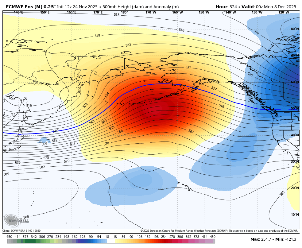
Pacific jet is trending more equatorward towards mid-month, leading to a better wave break and more poleward ridging near AK… this makes sense given the MJO
-
You hate to see good starts get cleaned out only to start over again, I think it was 20-21 back where we were off to a good December with 16.1" here then the grinch appeared and the rest of that winter was mediocre with 29.5".
-
Nov 28-30th Post Turkey Day Wintry Potential
Stebo replied to Chicago Storm's topic in Lakes/Ohio Valley
Peoria is pretty far south, so yeah being skeptical down there is a good move. This is probably more of an I-80 north threat. -
2025-2026 ENSO
40/70 Benchmark replied to 40/70 Benchmark's topic in Weather Forecasting and Discussion
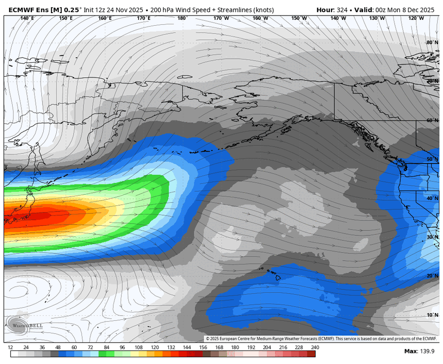
I'm waiting for Bluewave to embed a tweet about how fast of a flight it was from Tokyo to San Francisco, and then a 1994-2015 minus 2016-2025 250mb zonal wind graphic -
Nov 28-30th Post Turkey Day Wintry Potential
Radtechwxman replied to Chicago Storm's topic in Lakes/Ohio Valley
That's what I'm hoping but not holding my breath -

Nov 28-30th Post Turkey Day Wintry Potential
Malacka11 replied to Chicago Storm's topic in Lakes/Ohio Valley
No stop you're supposed to be depressing quit it before this autistic obsession actually becomes enjoyable again -
Models have trended towards swinging the winds around to the WNW a bit quicker over the last day or so…suspect the lake effect will struggle to push south of Lake County and far northern Geauga until late Thursday, but then there’s a pretty prolonged and decent WNW flow setup Thursday evening through most of Friday. Should be a solid setup for eastern Cuyahoga into Geauga and through the rest of the inland snowbelt. I could see the lakeshore struggling given the very strong winds over the water and fairly quick wind shift to WNW, but there may be a smaller area where banding sits on Thursday along the lakeshore (possibly in Lake or Ashtabula Counties) that does quite well.
-
Nov 28-30th Post Turkey Day Wintry Potential
Stebo replied to Chicago Storm's topic in Lakes/Ohio Valley
The amount of cold air being in place before this lifts out will be hard to shunt away. I am not surprised by the amount of WAA snows the models are showing. -

December 2025 regional war/obs/disco thread
powderfreak replied to Torch Tiger's topic in New England
Hard to hate the start so far too. Even low elevation woods are ok… we’ll see in a couple days though, haha.
-
Now that would make me eat my words. Huge ridge out west with some increasing heights in the NAO domain.
-
Hopium is back!
-
Same crap different season. It's fun to watch. Get ya popcorn!
-

E PA/NJ/DE Autumn 2025 Obs/Discussion
PhiEaglesfan712 replied to PhiEaglesfan712's topic in Philadelphia Region
Now that drought guy is doubting it, I'm optimistic about this storm happening. -

Nov 28-30th Post Turkey Day Wintry Potential
ILSNOW replied to Chicago Storm's topic in Lakes/Ohio Valley
AKA Rain Man.