All Activity
- Past hour
-

First Winter Storm to kickoff 2025-26 Winter season
ORH_wxman replied to Baroclinic Zone's topic in New England
06z GFS had it pinned in roughly the same spot too. But this is a situation where like 10 miles could be the difference between 10" of cement and 2" of slop. -
First Winter Storm to kickoff 2025-26 Winter season
KTBFFH1905 replied to Baroclinic Zone's topic in New England
Hoping for at least 3-6 for us here in Avon. -
Picked up 2.5" last night... nice surprise.
-

Pittsburgh/Western PA WINTER ‘25/‘26
jwilson replied to Burghblizz's topic in Upstate New York/Pennsylvania
Tomorrow looks like a classic southern slider with just enough northern stream interaction to get us 2-3" and keep the rain at bay, except for those in the southernmost counties, of course. The warm tongue is undefeated. Not likely to find any big events in this pattern, but the next couple weeks look okay for those old-timey Alberta Clippers. I'm sure we'll take any snow while we can get it. It should make things look festive around these parts until the (perhaps brief) Christmas warmup. -

First Winter Storm to kickoff 2025-26 Winter season
Snowcrazed71 replied to Baroclinic Zone's topic in New England
Lol... Sorry to disappoint. I'm actually in Plainville which is just next to Farmington west of Hartford. All kidding aside, I thought The Nam was in range within 24 hours at the start of the storm. Not that I'm going with the NAM LOL. -

First Winter Storm to kickoff 2025-26 Winter season
CoastalWx replied to Baroclinic Zone's topic in New England
Either slush or the grid goes down in Holliston. -
(002).thumb.png.6e3d9d46bca5fe41aab7a74871dd8af8.png)
Central PA Fall Discussions and Obs
ChescoWx replied to ChescoWx's topic in Upstate New York/Pennsylvania
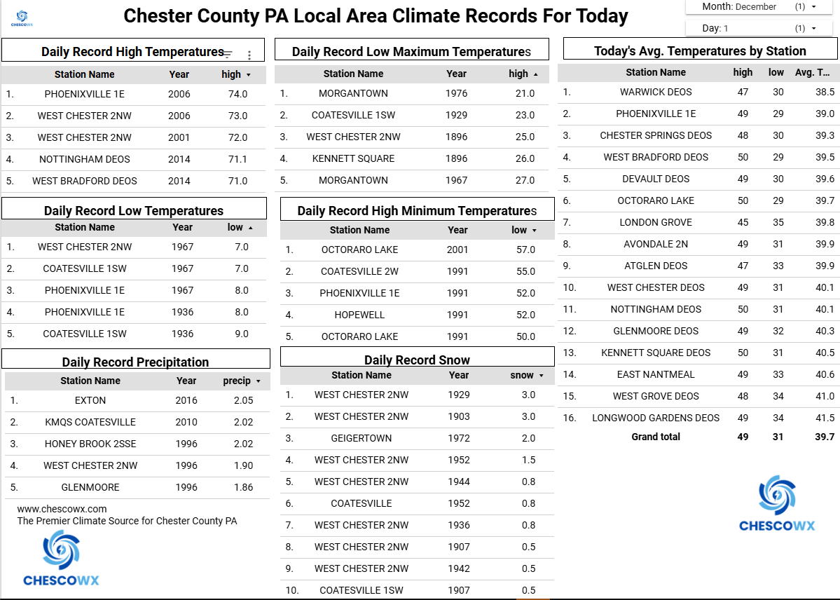
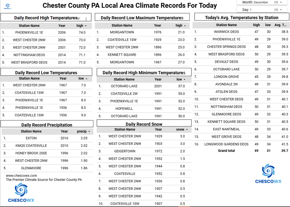
November finished as our 3rd below average temperature month over the last 4 months. December looks to also be getting off to a well below normal temperature start. Sunny today but with temperatures almost 10 degrees below normal for highs. Clouds roll in tonight with some snow arriving toward dawn. The Winter Weather Advisory starts at 4am for Western Chester County. Any snow to start should quickly change to sleet and then rain with little if any accumulation. That said with the timing near rush area it may be a bit slippery for the morning commute. High temperatures Tuesday through Thursday will be in the mid 30's well below average but fall even further below average by Friday as the coldest air of the season arrives. Temperatures on Friday will stay in the 20's. Another wintry event is possible by Friday night into Saturday.
-

First Winter Storm to kickoff 2025-26 Winter season
HoarfrostHubb replied to Baroclinic Zone's topic in New England
Timing seems a little slower (for the outset in my area) -
E PA/NJ/DE Winter 2025-26 Obs/Discussion
ChescoWx replied to LVblizzard's topic in Philadelphia Region
November finished as our 3rd below average temperature month over the last 4 months. December looks to also be getting off to a well below normal temperature start. Sunny today but with temperatures almost 10 degrees below normal for highs. Clouds roll in tonight with some snow arriving toward dawn. The Winter Weather Advisory starts at 4am for Western Chester County. Any snow to start should quickly change to sleet and then rain with little if any accumulation. That said with the timing near rush area it may be a bit slippery for the morning commute. High temperatures Tuesday through Thursday will be in the mid 30's well below average but fall even further below average by Friday as the coldest air of the season arrives. Temperatures on Friday will stay in the 20's. Another wintry event is possible by Friday night into Saturday.
-
First Winter Storm to kickoff 2025-26 Winter season
CoastalWx replied to Baroclinic Zone's topic in New England
Yeah saw that. Certainly crushes you. -
 Personally, I think that there should be a headline. Even if NYC, its nearby suburbs, and Long Island won't be getting much, if any, snowfall, parts of the forum will.
 -
First Winter Storm to kickoff 2025-26 Winter season
CoastalWx replied to Baroclinic Zone's topic in New England
If you just showed me that low track, even this time of year would offer interesting weather. A shame the high retreats prior. -
First Winter Storm to kickoff 2025-26 Winter season
ORH_wxman replied to Baroclinic Zone's topic in New England
The really high resolution stuff (HRDPS/3k NAM/etc) overnight keeps the CF pretty far east. like near 128 or even slightly east (further north you go the further east it gets)....that's something to watch because it's likely going to stay snow on the cold side of that....usually there is some enhanced lower level lift on the left side of that CF which will help to cool that lower 900-950mb layer a little bit...which will obviously matter if we have temps near 0C in that layer. -
First Winter Storm to kickoff 2025-26 Winter season
HoarfrostHubb replied to Baroclinic Zone's topic in New England
Thundersnow up yer fanny -
Had 10 days with precipitation in December to nickel myself to 0.89"
-
my kid failed geometry call that a bad son angle
-
Haven’t looked today. Hope it’s still there.
-
First Winter Storm to kickoff 2025-26 Winter season
CoastalWx replied to Baroclinic Zone's topic in New England
3K Nam soundings are hilarious here. One big hole ripped into the atmosphere with all sorts of lift in the DGZ, unstable layers etc. If only. -
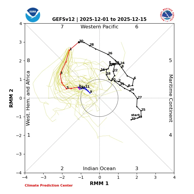
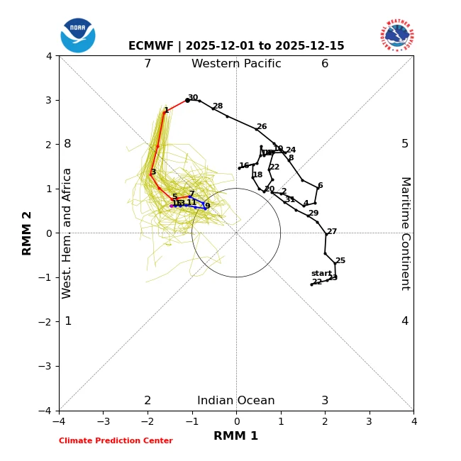
Today’s 2 week MJO forecasts: GEFS/EPS agree on longest winter phase 8 in 50 years that starts on Wednesday, even longer than the very long/very cold ones of Feb of 2010, Dec of 1989, and Jan of 1985:
-

December 2025 regional war/obs/disco thread
40/70 Benchmark replied to Torch Tiger's topic in New England
Yea, that is the next bonafide threat...will probably hit that up late week. -

First Winter Storm to kickoff 2025-26 Winter season
Great Snow 1717 replied to Baroclinic Zone's topic in New England
What is your problem with my post regarding the models?? Lol -
December opens up with a morning low of 6F and a snow depth of 7” Below zero temps likely later this week.
-

First Winter Storm to kickoff 2025-26 Winter season
Chrisrotary12 replied to Baroclinic Zone's topic in New England
ineedsnow's idea sounds about right for us. Probably closer to 6 than 10. But slightly concerned about power issues with the column potentially looking like this: -
First Winter Storm to kickoff 2025-26 Winter season
CoastalWx replied to Baroclinic Zone's topic in New England
Will be the new replacement for Nam and hrrr. Sometime in 2026 but it still needs work. -
December 2025 regional war/obs/disco thread
40/70 Benchmark replied to Torch Tiger's topic in New England
I never really saw the appeal...I kept looking for something to write about, but never found anything.