All Activity
- Past hour
-

The “I bring the mojo” Jan 30-Feb 1 potential winter storm
lilj4425 replied to lilj4425's topic in Southeastern States
I’m bringing the mojo. -

The “I bring the mojo” Jan 30-Feb 1 potential winter storm
kvegas-wx replied to lilj4425's topic in Southeastern States
This is really gonna happen. Forum wide snow dancing. The rarest of rare events. -

The “I bring the mojo” Jan 30-Feb 1 potential winter storm
BooneWX replied to lilj4425's topic in Southeastern States
Beautiful run from ol’ big head -
I don’t know if you saw bouncycorn’s reply, but this is what he said and posted this graphic : NBMv4 has these models/weights: NBMv5 (parallel) is a bit different but the weights haven't been released. Pretty sure they removed SREF and added AI Models (like AIFS). They also do some different bias correction methods in v5 such as probability matched mean to achieve more accurate/unsmoothed outputs. .
-
GFS looks good

-

The “I bring the mojo” Jan 30-Feb 1 potential winter storm
USCG RS replied to lilj4425's topic in Southeastern States
Wow. GFS is rocking with this run. -
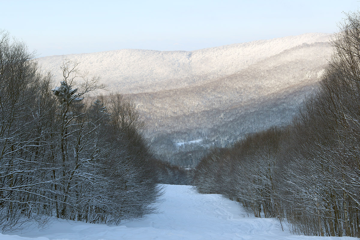
As of yesterday morning, the mountains had picked up another few inches of snow from the disturbance coming through the area on Tuesday, so I headed up to Bolton Valley for a tour. The Timberline Quad was set to start running at 9:30 AM for the first time this week, so getting in ahead of that opening was the best bet for untouched snow ahead of the lift-served traffic. Temperatures have remained much better than the cold we saw over the weekend – with temps running around 10 F and minimal wind present, the skiing is a lot more comfortable, especially while touring. With the additional snow from the end of Winter Storm Fern and this more recent system, powder depths were a bit deeper yesterday than what I’d found on Monday. Depth measurements were more in the 15-20” range vs. the 12-18” range that was out there before. The powder didn’t come across quite as dry as what was out there on Monday, since the snow from this disturbance has been coming in with snow densities in the 3-6% range vs. those 1-3% readings from the end of Winter Storm Fern, but it was still fantastic midwinter champagne powder - you’d be hard pressed to tell the difference unless you were out there both days and paying close attention.

-

Richmond Metro/Hampton Roads Area Discussion
chris624wx replied to RIC Airport's topic in Mid Atlantic
00Z GFS more NW with precip shield too! -

The “I bring the mojo” Jan 30-Feb 1 potential winter storm
Rsheely88 replied to lilj4425's topic in Southeastern States
. -
I saw a halo around the moon earlier and thought the same thing.
-
The “I bring the mojo” Jan 30-Feb 1 potential winter storm
Rsheely88 replied to lilj4425's topic in Southeastern States
GFS looking much better, low getting tucked into hatteras . -

Possible coastal storm centered on Feb 1 2026.
met_fan replied to Typhoon Tip's topic in New England
The streets and parking lots are all a matter of how well the snow was cleared. In my town the streets are all clear and dry, but I’ve driven through neighboring towns that are still a mess. -

The “I bring the mojo” Jan 30-Feb 1 potential winter storm
WEATHER53 replied to lilj4425's topic in Southeastern States
Mid Atlantic guy but go get this one. 50+ gusts and you will have 4-6’+ drifts everywhere, Did in 1966 Maryland eastern shore . Just got smacked here for 9”’and 7”!s still around. Now your turn!!!! -
Just die (wind)
-
The “I bring the mojo” Jan 30-Feb 1 potential winter storm
USCG RS replied to lilj4425's topic in Southeastern States
Looks to me like it's just more robust. -
The “I bring the mojo” Jan 30-Feb 1 potential winter storm
Rsheely88 replied to lilj4425's topic in Southeastern States
. -

The “I bring the mojo” Jan 30-Feb 1 potential winter storm
BornAgain13 replied to lilj4425's topic in Southeastern States
Ok so is the precip trending north or what? Looks like it did on the RGEM -
NWS just updated WSW…now says 3-5 inches Winter Storm Warning URGENT - WINTER WEATHER MESSAGE National Weather Service Morristown TN 1036 PM EST Thu Jan 29 2026 TNZ015-038-039-069>071-073-VAZ001-301800- /O.CON.KMRX.WS.W.0003.260130T1800Z-260201T0600Z/ Hancock-Grainger-Hamblen-Knox-Jefferson-Northwest Blount-North Sevier-Lee- Including the cities of Chestnut Hill, Strawberry Plains, Kodak, Dandridge, Pigeon Forge, McMahan, Happy Valley, Jefferson City, Knoxville, Alcoa, Sevierville, Sneedville, Kyles Ford, Treadway, Harrisburg, Morristown, Bearden, Seymour, Rose Hill, Evanston, Alpha, Maryville, Bean Station, Lake Forest, Russellville, and White Pine 1036 PM EST Thu Jan 29 2026 ...WINTER STORM WARNING REMAINS IN EFFECT FROM 1 PM FRIDAY TO 1 AM EST SUNDAY... * WHAT...Heavy snow expected. Total snow accumulations between 3 and 5 inches. * WHERE...Portions of east Tennessee and southwest Virginia. * WHEN...From 1 PM Friday to 1 AM EST Sunday. * IMPACTS...Travel could be very difficult. The hazardous conditions could impact the Friday evening commute. PRECAUTIONARY/PREPAREDNESS ACTIONS... If you must travel, keep an extra flashlight, food, and water in your vehicle in case of an emergency. The latest road conditions for the state you are calling from can be obtained by calling 5 1 1. &&
- 507 replies
-
- 3
-

-
- extreme cold
- snow
- (and 1 more)
-

1-30/2-1-26 Arctic Blast, ULL Snow Event
Daniel Boone replied to John1122's topic in Tennessee Valley
Yeah, that one is a real confidence booster ! -
Both my street and parking lot are still packed with snow. And it still feels like navigating little mountains whenever I try to move around.
-
Probably not for most but far eastern LI/Twin Forks could get a late surprise, wouldn't take much.
-
1-30/2-1-26 Arctic Blast, ULL Snow Event
Daniel Boone replied to John1122's topic in Tennessee Valley
Yep. That settles it . -
The “I bring the mojo” Jan 30-Feb 1 potential winter storm
USCG RS replied to lilj4425's topic in Southeastern States
Side note. Your handle (screen name) is awesome. -
The “I bring the mojo” Jan 30-Feb 1 potential winter storm
BooneWX replied to lilj4425's topic in Southeastern States
OBX and Tidewater are good candidates -

1-30/2-1-26 Arctic Blast, ULL Snow Event
Carvers Gap replied to John1122's topic in Tennessee Valley
The 0z RGEM is a decently marked increase. Shift west with short range models at 0z.- 507 replies
-
- 3
-
-

-
- extreme cold
- snow
- (and 1 more)