All Activity
- Past hour
-
By inner city standards it’s just another aroma amongst the many. Stay well, as always …..
-
Now this is a watch

-
Yeah I dont know. I have had spider bites get infected and they looked similar. A particularly bad one had a large 7-8" ring with a center that looked similar.
-
its really not bad all... most places have ac that you walk into and most lines have strong fans with water misting out
-
Columbia: 0.11” today as of 4pm.
-
I will say, with regard to bug bites, I’ve never had a doctor that was super confident with what it might be, unless of course you actually saw or caught the perpetrator.
-
Again, who knows but tick bites definitely tend to be a brighter red than that one. I’ve had and seen many over the years.
-

June 8 Southern Plains Severe Outbreak
canderson replied to Powerball's topic in Central/Western States
It’s hailing just to the’east of Longview -
Anyone see the video's of Howe Caverns and the flooding they received yesterday?
-
This storm locally caused some damage west of Chicago and now looks like a supercell
-
And dropped. It was spinning but it didn’t seem to ever drop
-
Some of those showers were downpours. We went downtown to the Arts Festival. Even with umbrellas and rain jackets had to hang in a few of the tents till it let up.
-
another cool drab cloudy weekend day and now showers in the vicinity...i see showers and 69 showing up on my exteneded forecast for June 15....#yearwithoutasummer is a thing
-

June 8 Southern Plains Severe Outbreak
Powerball replied to Powerball's topic in Central/Western States
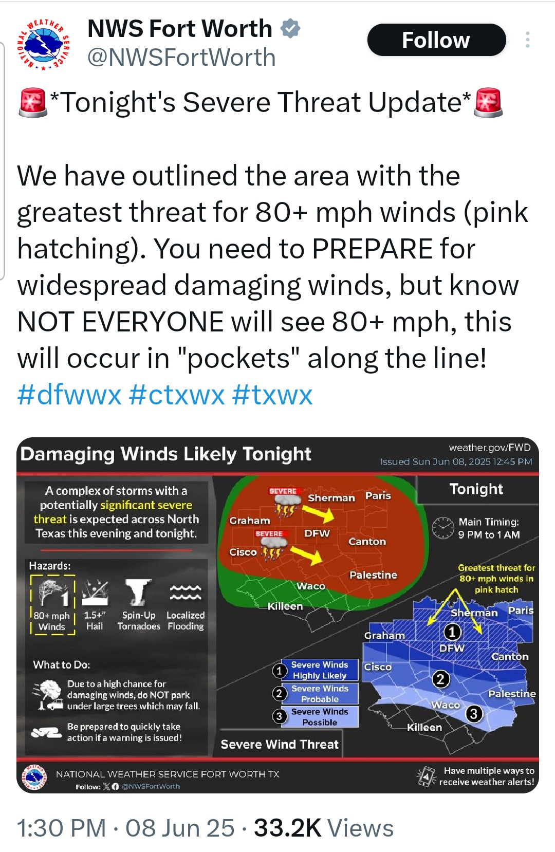
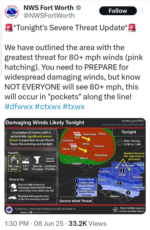
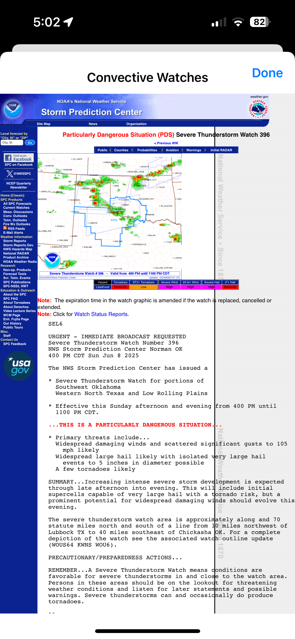
Either a PDS Severe Watch or Tornado Watch is coming shortly for parts of North / NW Texas... -
Seems like a lot of the "interesting" weather in PA has been focused in western part of the state.
-
-
Tornado Warning for the city of Pittsburgh.
-
Depends on property size in suburbia.
-
June 8 Southern Plains Severe Outbreak
Powerball replied to Powerball's topic in Central/Western States
- Today
-
It's definitely much better in the Poconos.
-
Sitting around outside with a fire is pretty nice, but in suburbia, its an annoyance to your neighbors...
-
Raining
-
Tornado Warning PAC129-082015- /O.NEW.KPBZ.TO.W.0018.250608T1947Z-250608T2015Z/ BULLETIN - EAS ACTIVATION REQUESTED Tornado Warning National Weather Service Pittsburgh PA 347 PM EDT Sun Jun 8 2025 The National Weather Service in Pittsburgh has issued a * Tornado Warning for... Southwestern Westmoreland County in southwestern Pennsylvania... * Until 415 PM EDT. * At 347 PM EDT, a severe thunderstorm capable of producing a tornado was located near West Newton, or 8 miles southwest of Jeannette, moving east at 15 mph. HAZARD...Tornado. SOURCE...Radar indicated rotation. IMPACT...Flying debris will be dangerous to those caught without shelter. Mobile homes will be damaged or destroyed. Damage to roofs, windows and vehicles will occur. Tree damage is likely. * Locations impacted include... Greensburg, Youngwood, New Stanton, Madison, Arona, Hunker and Herminie. PRECAUTIONARY/PREPAREDNESS ACTIONS... Move to an interior room on the lowest floor of a well-built building away from windows. If you are outdoors, in a mobile home, or in a vehicle, move to the closest substantial shelter and protect yourself from flying debris. Highway overpasses are not safe shelters. If you cannot safely drive away from the tornado, as a last resort, abandon your vehicle and lie down in a low lying area and protect yourself from flying debris. && LAT...LON 4022 7976 4028 7972 4030 7952 4018 7955 TIME...MOT...LOC 1946Z 262DEG 13KT 4024 7970 TORNADO...RADAR INDICATED MAX HAIL SIZE...0.00 IN $$ TC Severe Weather Statement National Weather Service Pittsburgh PA 341 PM EDT Sun Jun 8 2025 PAC125-082000- /O.CON.KPBZ.TO.W.0017.000000T0000Z-250608T2000Z/ Washington PA- 341 PM EDT Sun Jun 8 2025 ...TORNADO WARNING REMAINS IN EFFECT UNTIL 4 PM EDT FOR NORTHWESTERN WASHINGTON COUNTY... At 341 PM EDT, a severe thunderstorm capable of producing a tornado was located 7 miles north of Wolfdale, or 7 miles east of Avella, moving east at 20 mph. HAZARD...Tornado. SOURCE...Radar indicated rotation. IMPACT...Flying debris will be dangerous to those caught without shelter. Mobile homes will be damaged or destroyed. Damage to roofs, windows and vehicles will occur. Tree damage is likely. Locations impacted include... Cecil-Bishop, McDonald, Hickory, Midway and Atlasburg. PRECAUTIONARY/PREPAREDNESS ACTIONS... Move to an interior room on the lowest floor of a well-built building away from windows. If you are outdoors, in a mobile home, or in a vehicle, move to the closest substantial shelter and protect yourself from flying debris. && LAT...LON 4028 8039 4033 8040 4039 8026 4037 8023 4027 8020 TIME...MOT...LOC 1934Z 272DEG 17KT 4030 8037 TORNADO...RADAR INDICATED MAX HAIL SIZE...0.00 IN $$ TC
-
Only signs I noticed were “no alcohol allowed”
-
Did you notice any "Ticks Please Stay Off the Concrete" signs around? ....have it checked for peace of mind


.thumb.png.4150b06c63a21f61052e47a612bf1818.png)