All Activity
- Past hour
-
Cant wait to be posting clown maps for that one this time next week only for it to end up in shifting to Miami 3 days out. It can snow to the north or the south, but never the interior southeast anymore. Prove me wrong atmosphere.
-

E PA/NJ/DE Winter 2025-26 Obs/Discussion
RedSky replied to LVblizzard's topic in Philadelphia Region
CMC with a clipper three days post storm -

-
Yea. There’s always a storm that somehow misses the upstate and wnc foothills. 4 years running.
-
That's actually fucking insane.
-

Possible Record Breaking Cold + Snow Sunday 1/25 - Tuesday 1/27
Snowlover11 replied to TriPol's topic in New York City Metro
Hazardous Weather Outlook National Weather Service New York NY 121 AM EST Wed Jan 21 2026 CTZ005>012-NJZ002-004-006-103>108-NYZ067>075-078>081-176>179-220630- Northern Fairfield-Northern New Haven-Northern Middlesex- Northern New London-Southern Fairfield-Southern New Haven- Southern Middlesex-Southern New London-Western Passaic- Eastern Passaic-Hudson-Western Bergen-Eastern Bergen-Western Essex- Eastern Essex-Western Union-Eastern Union-Orange-Putnam-Rockland- Northern Westchester-Southern Westchester-New York (Manhattan)-Bronx- Richmond (Staten Island)-Kings (Brooklyn)-Northwest Suffolk- Northeast Suffolk-Southwest Suffolk-Southeast Suffolk- Northern Queens-Northern Nassau-Southern Queens-Southern Nassau- 121 AM EST Wed Jan 21 2026 This Hazardous Weather Outlook is for southern Connecticut, northeast New Jersey and southeast New York. .DAY ONE...Today and tonight. Hazardous weather is not expected at this time. .DAYS TWO THROUGH SEVEN...Thursday through Tuesday. Confidence is increasing in the potential for a significant winter storm to impact the area Sunday into Monday with accumulating snowfall. .SPOTTER INFORMATION STATEMENT... Spotter activation is not expected at this time. && This Hazardous Weather Outlook provides a summary of potential widespread hazardous weather events that may reach NWS warning criteria. Most long fused NWS watches, warnings, and advisories in effect are highlighted. Please refer to the latest NWS forecasts for weather not meeting NWS warning criteria. $$ -
WB EURO AI EPS
-
Or old school "coal oil" lamps always loved that smell when the power went out as a kid down here in the hills , especially in winter..
-

January 2026 regional war/obs/disco thread
Ginx snewx replied to Baroclinic Zone's topic in New England
Historical these people are not prepared for what is about to hit them.png.8fb077f1ed04ea9968c1dce724b5bf20.png)
.png.e4eab2f457c0dee423a8eda38b2d2a04.png)
.thumb.png.eefd8418e9d738136e9d0f914c198ec9.png)
.thumb.png.8e1e37cf5a9fec43cfabc35a5657ee54.png)
-

-

January 2026 regional war/obs/disco thread
wxsniss replied to Baroclinic Zone's topic in New England
0z EPS jumped ~150 north compared to 12z EPS mean QPF now 0.7-1" all of SNE -
Don't say that...we were planning to come home from Davis Sat night to catch the snow here. I've already stocked firewood and i am ready for ripping snow during the AFCCG. I could adjust and ride it out up there but we have elderly neighbors here we take of during snow. Ugh. Decisions decisions
-
 we hope for the CMC solution at this point I don't think any of us want mixing!
 -
I’m legit gutted
-

Possible Record Breaking Cold + Snow Sunday 1/25 - Tuesday 1/27
David-LI replied to TriPol's topic in New York City Metro
yeah not buying it until we get NAM'D! -
That's really perfection. Let's lock that in now lol. All the ensembles should calm the nerves a little
-

January 25/26 Jimbo Back Surgery Storm
Silver Meteor replied to Jimbo!'s topic in Southeastern States
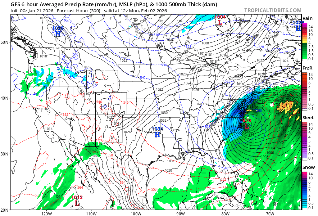
Hey folks, there's always the Feb 2 storm. What could go wrong?
-
Can I just sign on the dotted line already
-
Euro AI Ensemble is ridiculous
-
Well… I’ll be at the movies all weekend. Anyone care a movie weekend in Charlotte.
-

Possible Record Breaking Cold + Snow Sunday 1/25 - Tuesday 1/27
RU848789 replied to TriPol's topic in New York City Metro
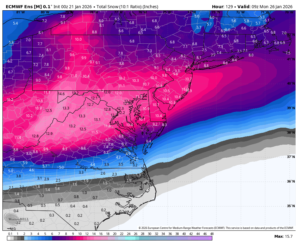
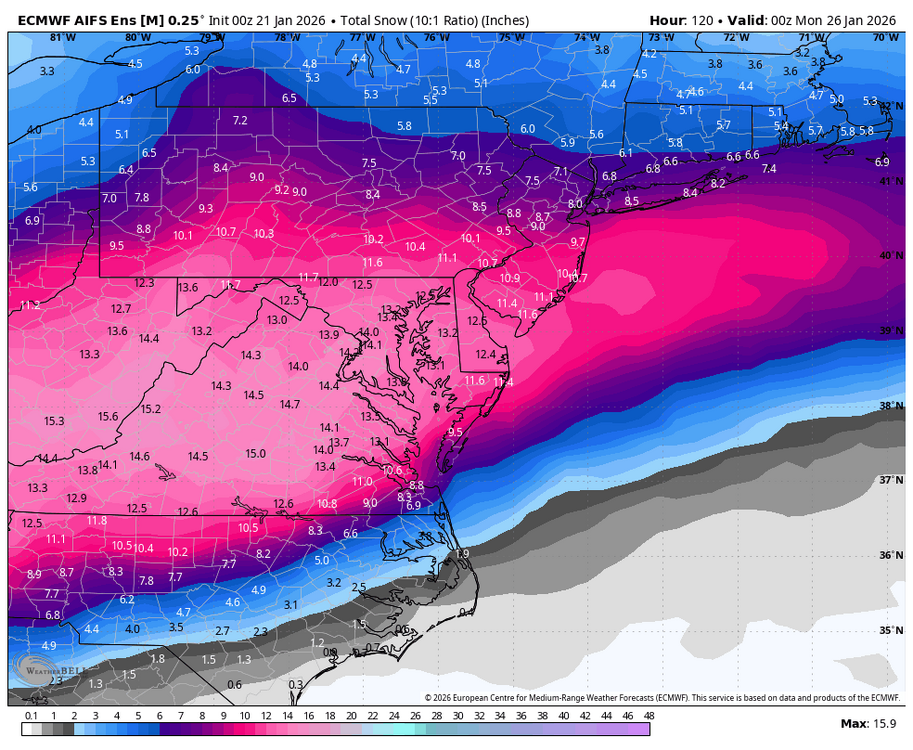
Not sure if folks will find this useful, but I post this model summary info in a few other places (FB/non-weather forums/my email list) and folks seem to like it, as it provides a decent summary without posting 14 maps, so thought I'd see what people thought. These are model summaries from 0Z for CNJ and the immediate PA counties bordering CNJ, i.e., areas between 276/195 and 78, as well as for NENJ (eastern Union/Essex and Hudson) along 95 and NYC. I also include the estimated snowfall amounts at both 10:1 and 15:1, which is my guess for ratios we'll see (I know some think we'll see higher, but I'm not ready to go there yet), plus I included the same info from the 12Z runs of these models. GFSAI isn't included as I don't have direct snow info for that model (but we know it's no longer an outlier based on QPF). As an aside, I've never seen model consensus like this 4.5 days out (or maybe even 4.5 hours out, lol. Comments welcome. The Euro shows 10-12" at a 10:1 ratio and 15-18" at a 15:1 ratio and the 12Z run was 7-10". The Euro AIFS shows 8-11" at a 10:1 ratio and 12-16" at a 15:1 ratio and the 12Z run was 5-8." The GFS shows 8-11" at a 10:1 ratio and 12-16" at a 15:1 ratio and the 12Z run showed nada for CNJ. The CMC shows 10-13" at a 10:1 ratio and 15-20" at a 15:1 ratio and the 12Z run was 7-11". The UK shows 10-13" at a 10:1 ratio and 15-20" at a 15:1 ratio and the 12Z run was 9-12". The ICON shows 8-10" at a 10:1 ratio and 12-15" at a 15:1 ratio and the 12Z run was also 8-10". The NBM (model blend) shows 11-14" at a 10:1 ratio and 16-21" at 15:1 ratios and the 12Z run was 8-12". -

Winter 2025-26 Short Range Discussion
hawkeye_wx replied to SchaumburgStormer's topic in Lakes/Ohio Valley
Meanwhile, a few miles to your south we got a couple tenths at first, but, even though radar suggested good snow for the last couple hours, it stopped snowing completely. The southern edge snow must be drying up as it falls. -
Yeah I honestly hate to sound like this but im sick... this is awful for the forum.
-
EPS.

-

MO/KS/AR/OK 2025-2026 Winter Discussion
stormdragonwx replied to stormdragonwx's topic in Central/Western States
Indeed I suspect Lucy is really trolling hard with the football tonight. I remember the storm last Feb was putting out crazy amounts but in reality it was just 6 inches. Not that I was complaining. lol


.png.481f01ae5044630e0bb67704073149ff.png)
.png.184ca3041645739cacf820d26d113d8f.png)