All Activity
- Past hour
-

Hurricane Erin: 100 MPH - 954 mb - NNW @ 13
RaleighNC replied to BarryStantonGBP's topic in Tropical Headquarters
Same energy:
-
Be safe up there with those high dews through Halloween.
-
Yes lol that’s what he SHOULD do. Instead we’ll probably get Charlie morton back
-
When will the flooding begin?
-
<0.1" so far. I hope the humid humpers are outside enjoying the 95+% humidity that they crave.
-

2025 Lawns & Gardens Thread. Making Lawns Great Again
SJonesWX replied to Damage In Tolland's topic in New England
you are close to the optimal reseeding time for sure. I do my overseeding every year on Labor Day weekend. -
Something between his current self and AJ Preller would be great. Talk about a guy going for it every trade deadline. Do they even have a current AAA roster?
-

Hurricane Erin: 100 MPH - 954 mb - NNW @ 13
wthrmn654 replied to BarryStantonGBP's topic in Tropical Headquarters
For anyone wanting a super amazing zoomable interactive any model know to humans viewer, https://nhc-display.ral.ucar.edu/nhc-display/ It's so wowing. -
good soaking here this morning and much needed.. 55.8 with some rain still around
-
It's a weak ass PRE if that were the case.
-
You would think they would be in the market for a front line starter wether through free agency or via trade and also a mid rotation type. You can never have enough with arm injuries these days. I wouldn't count on getting anything from Rodriguez and who knows with Bradish/ Wells coming off TJ. Wells is better suited for a set up man IMO. Yes, Rodgers has been amazing but is it a blip or is he suddenly a staff ace.
-
Hurricane Erin: 100 MPH - 954 mb - NNW @ 13
wthrmn654 replied to BarryStantonGBP's topic in Tropical Headquarters
Looking at the nhc model viewer for 06z run, it would appear only 2 models showed it at the most recent position, both i believe are hurricane models,.
-
Disrespectful is a good way to describe foul weather. I'll have to remember that! Yeah the worst heat should break for the season after today (Wednesday). Some folks I-40 north are already in the new airmass. Still cookin' south of the front! As usual I forecast this first CF to be weaker than progged. NAM 2m is too cool. MOS and NWS are on that with average highs (aggregate region) 88-90 through Sunday. Some will enjoy 80s esp up on the Plateau and near Kentucky. The rest of us will have to wait for front #2. Clark she's a beaut! -Cousin Eddy First front is mostly low levels behind Erin with only modest Td improvement. Second front for Monday has true upper air support with trough over GL even OV. That'll deliver for our Tenn Valley including scouring some dews. Then the trough pattern seems to hold for a week to 10 days from Monday. Looks like it might warm up again after Labor Day but we're talking around 90 with lower humidity and ever lower sun angle. That'd doable.
-

Hurricane Erin: 100 MPH - 954 mb - NNW @ 13
olafminesaw replied to BarryStantonGBP's topic in Tropical Headquarters
Yep, the GFS is showing the biggest waves pushing in between 6 pm and 4 am -
Hurricane Erin: 100 MPH - 954 mb - NNW @ 13
wthrmn654 replied to BarryStantonGBP's topic in Tropical Headquarters
And, looking at the track the most recent positioning is more west versus the past few plots, maybe a wobble, or new center who knows. -
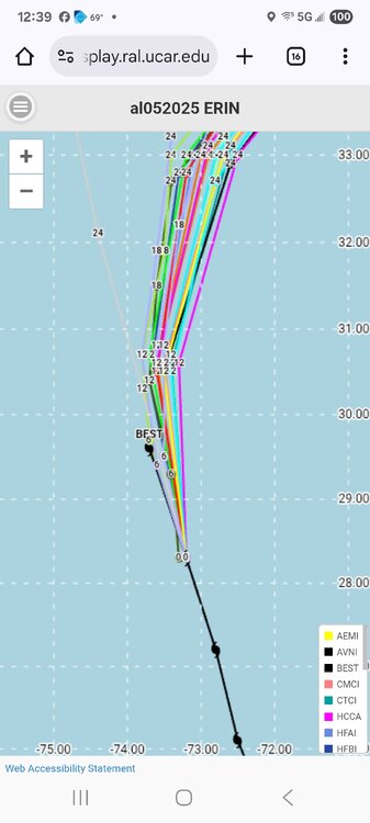
Hurricane Erin: 100 MPH - 954 mb - NNW @ 13
wthrmn654 replied to BarryStantonGBP's topic in Tropical Headquarters
Looking at 6z model plots versus storm position the storm is west of models at its 12z position, interestingly. See photo Looking at the consensus and offical tracks north are north and west cost to when it is nearing its north east turn. They said they didn't change the forecast track but looking at the wind graphic, it's very much changed as parts are the most east long island etc are in the 5%chance now for tropical storm force winds now. I -
 Chilly and damp here with some occasional light drizzle. I'm hoping for 1/2" at least. So dry.
 -

Central PA Summer 2025
Mount Joy Snowman replied to Voyager's topic in Upstate New York/Pennsylvania
Some nice showers rolling through here in Harrisburg over the lunch hour. -
Yeah, I lean away ... but admit to some similarities. I tried to provide a little analysis but just sayn' ... we probably can't positive eliminate it altogether.
-
Just a little light rain here, now it's dry.
-
Now if we could only get the western pacific to stop boiling we might have a 2010s style winter!
-

Hurricane Erin: 100 MPH - 954 mb - NNW @ 13
LongBeachSurfFreak replied to BarryStantonGBP's topic in Tropical Headquarters
Exactly, those high tides will be the issue. Further north it’s tomorrow evenings high tide. I’m in Montauk right now and the beach is washed out right to the dunes. And we haven’t even seen anything close to what’s coming tomorrow up here. -
I don’t really see it as a PRE. There is a low with a stalled front and WAA with it. Also H5 s/w. Maybe a couple of similarities, but I don’t see tropical moisture from Erin contributing much.
-

Hurricane Erin: 100 MPH - 954 mb - NNW @ 13
Kevin Reilly replied to BarryStantonGBP's topic in Tropical Headquarters
Thats probably later tonight and tomorrow morning I would think. -
Hurricane Erin: 100 MPH - 954 mb - NNW @ 13
LongBeachSurfFreak replied to BarryStantonGBP's topic in Tropical Headquarters
That’s due to the current swell direction being south. As the Erin gets to the obx latitude the largest fetch (allot of it pressure gradient driven) will be pointed east to west. And right at them. Thats when the damage will occur.