All Activity
- Past hour
-
79° for the high here today. I think we had more clouds though. Colleagues in Moretown and Cambridge said they had sun while I still had overcast.
-
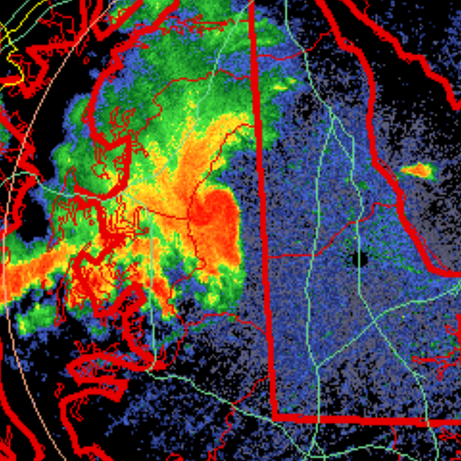
^Ridgley mesonet station gusted to M51 mph. Just north of that little mesolow or ball of whatever that is.
-
Thats what I was referring to, pretty cool . Never seen that before over the years.
-
That eye looks very impressive, embedded right in the center of the bursting convection.
-
Ya I don't get it at all.. Warning Warning Install Install
-
Cool depiction on radar. Ofc I am just north of that ball of red in the notch lol. Booming thunder.

-
The line is weakening a bit up here. I think it’s outrunning the best dynamics.
-
I take my puppy out several times a day and no matter the time of day or weather I get eaten alive. It's been a boon year for skeeters.
-
Dancing Wein?
-
Crazy Yin-Yang storm image from the cell near Holly Hill Estates MD, crazy time loop.
-
Hit 90 before when the sun was out. 74 dew point, yuck
-
ABBA MCS So when you're near me, Darlin can't you hear me? MCSThe love you gave me, Nothing else could save me, MCSWhen your gone, How can I even try to go on, When your gone, though I try, How can I carry on?
-
Destructive severe warning
-
Looks like around 0.9” from the afternoon storms on top of 0.4-0.5” overnight.
-
Only 75/70 (Temp/Dew point) here on the south shore with full sun. Maxed at 79 around 2pm with 0.26" of rain this morning
-
Not sure why he cheers it on. He’s obsessed with hiding from it in AC.
-
Yeah, I'm sure farmers would disagree but I would sign up for 10 days of Stein if it was an option.
-
Wow, line kind of split, but mostly went poof. Ok, it weakened, and just a trace here so far. All that rushing around from lawn care and weeding the garden for nothing.
-
Yep. Sun’s out here and first summer true sauna afternoon.
-
Timing sucks for any MCS Saturday night, at least if you take a blend of the models. NNE could do well though
-
congrats to you on the high dews you have been begging for!!
-
This humidity sucks. If it’s going to be dewy at least let it be warm so it’s not sticky.
-
Next recon is en route and I fully expect at least a mid grade 3 by the time it arrives. I don’t think cat 4 before landfall is off the table. This is incredible for June
-
Hopefully we get a solid MCS...been quite some time since we had a solid legit MCS roll through
-
Mesoscale Discussion 1349 NWS Storm Prediction Center Norman OK 0238 PM CDT Wed Jun 18 2025 Areas affected...northern IN...southern Lower MI...northwest OH Concerning...Tornado Watch 434... Valid 181938Z - 182145Z The severe weather threat for Tornado Watch 434 continues. SUMMARY...Northern, fast-moving portion of a QLCS should progress across the rest of northern Indiana into southern Lower Michigan and northwest Ohio through early evening. Damaging winds should be the main threat, but a tornado or two will be possible. Downstream watch issuance expected by 21Z. DISCUSSION...The northern portion of a QLCS has been steadily progressing east around 45 kts with a history of estimated to measured gusts of 55-70 mph. This fast-moving portion of the line has likely outpaced stronger low-level shear across southwest IN, per comparison of VWX and IWX VWP data. Given largely veered surface winds downstream and recent HRRR guidance, an outflow-dominated line will likely persist as it spreads into southern Lower MI and northwest OH through early evening. Damaging winds should remain the primary hazard, with a tornado or two possible in any QLCS mesovortices across northern IN.


.thumb.png.4150b06c63a21f61052e47a612bf1818.png)


