All Activity
- Past hour
-
Next time Peter Geiger stops in, I'll have to ask him why they chose to no longer publish the Farmers Almanac.
-
"We are pleased to share the Maryland Climate Bulletin for October 2025, which includes sea surface temperatures for the Chesapeake Bay and the state's coastal waters. However, due to the federal government shutdown, the availability of our primary data source for the Bulletin has been affected, and consequently, the extent of the Bulletin has been impacted. The regular production of the Bulletin is only possible thanks to the hard work and data provided by our friends at NOAA National Centers for Environmental Information, the CoastWatch East Coast Node, the Institutions involved in the U.S. Drought Monitor, and the U.S. Geological Survey's Water Watch. You can access the Bulletin from the following link: https://mdsco.umd.edu/Bulletin/bulletin_mdsco_current.pdf Points to highlight are: 1) Statewide averages indicate that October 2025 was slightly colder and drier than normal (i.e., 1991-2020 averages). 2) Regionally, the mean temperature was warmer than normal in some areas of the state, particularly over counties in the central Piedmont and the Eastern Shore. Colder-than-normal conditions appeared over parts of Garrett, Prince George's, and Charles counties. 3) Precipitation was below normal for most of the state, especially over portions of Saint Mary's, Charles, Calvert, Somerset, Dorchester, and Talbot counties, which received around 50% less precipitation than normal for the month. Above-normal precipitation was observed only over western Washington County, which received approximately 25% more precipitation than normal. The rest of the state, with below-normal precipitation, received around 25% less precipitation than normal. 4) Drought conditions deteriorated in October. The extent of the state affected by drought increased from 50% to 90%, with a rise in the areas having Abnormally Dry and Moderate Drought conditions. Moderate Drought conditions affected Garrett, Allegany, Washington, Frederick, and Montgomery counties, as well as western Carroll, Howard, Prince George's, Charles, and northeastern Cecil counties. The Severe Drought conditions in Garrett and Washington counties, and the Extreme Drought conditions in Garrett County that appeared in September, persisted into this month. Abnormally Dry conditions covered the rest of the counties in the Piedmont, and most of the counties on the Eastern Shore; Worcester and Queen Anne's counties, as well as parts of Wicomico and Kent counties, remained drought-free. The number of streams and rivers experiencing Below-normal and Much-below-normal streamflow increased this month. 5) The Chesapeake Bay sea surface temperatures (SST) in October 2025 were in the 63−70°F range. Regionally, they were below their 2007–2020 mean across much of the Bay, except in the waters north of Baltimore, extending into the Upper Bay, where warm anomalies exceeded 4°F. The coldest anomalies were found in the southeastern Lower Bay, in the Tangier Sound waters off Somerset, Wicomico, and Dorchester counties, as well as in the Chincoteague Bay (3–4°F below). The all-basin mean temperature of 66.3°F was still warmer than the coldest October in the 19-year dataset (2007-2025), which recorded a temperature of 62.2°F in 2002. Please refer to the Bulletin for more details. The Maryland Climate Bulletin is issued monthly and presents the state's recent surface temperature and precipitation conditions in a clear and concise format, enabling Marylanders to better understand regional climate variations. Please help disseminate this Bulletin. Thanks, Alfredo -- ............................................. Alfredo Ruiz-Barradas, PhD Associate Research Professor Maryland State Climatologist"
-

November 2025 general discussions and probable topic derailings ...
Modfan2 replied to Typhoon Tip's topic in New England
Just need to see the same model output in the 2-4 day range -

2025-2026 ENSO
donsutherland1 replied to 40/70 Benchmark's topic in Weather Forecasting and Discussion
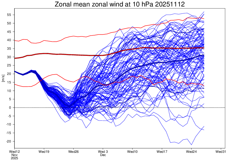
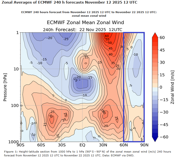
When it comes to sudden stratospheric warming events (SSWEs) or major stratospheric warming events (MSWEs), these events can be a response to strong blocking (bottom-up), which often reinforces and extends the blocking. They can also be top-down events that lead to a downward-propagating tropospheric response. Typically, there is approximately a 10-20-day lag, where the NAO/AO move toward and into a negative state. This blocking can then persist for 30 days and longer, with some fluctuations. Tropospheric responses to vortex-splitting events are often stronger than those for displacement events. However, more often than not, the larger portion of the split vortex winds up in Eurasia and the smaller one moves into North America. So, if the sudden or major stratospheric warming event occurs in the closing days of this month, its impact on North America would probably start to be seen near mid-December +/- few days. Right now, a major event with a wind reversal isn't assured. Also, the warming and wind reversal appear to be centered mainly south of 60N vs. the 60N-90N region that is conducive to triggering or extending Arctic blocking. Warming events centered south of 60N often do not produce the same downward-propagating tropospheric impacts of those that occur in the 60N-90N region. That's an important detail that will need to be considered.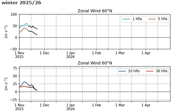
-

Occasional Thoughts on Climate Change
Typhoon Tip replied to donsutherland1's topic in Climate Change
You know ... speaking of diatribes ( lol ) ... wrote this paragraph in that missive, "At this stage of our species evolution we are brilliant enough to suspect if not outright predict calamity, yet too stupid to believe those visions ... Immediate gratifications and/or preexisting interests that have to be suspended in lieu of what those visions might suggest, becomes a conflict that won't be resolved until people see the death, and feel the pain." and it's too generalized. What's really going on is that a tiny fraction of living humans are brilliant enough to suspect if not outright predict calamity, but they cannot effect change because they are limited by the insurmountable masses of population that are too stupid to believe those visions ... There is a pyramid ignoramus dilemma. It's always been a problem for science that a single person .. or small constituency, discovers something huge, capable of truly revolutionizing an understanding of reality - necessarily so if we are all to be 'real' - but they are at the tip founded upon generations of tradition and functioning, unwitting false belief systems. -
That’s more important to snow around here in December than the NAO
-
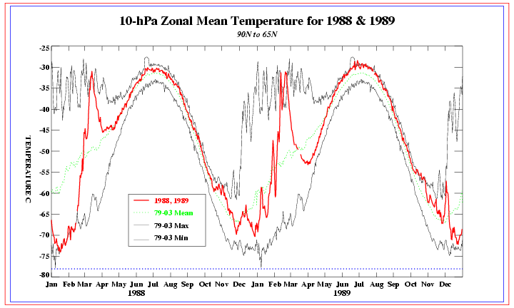
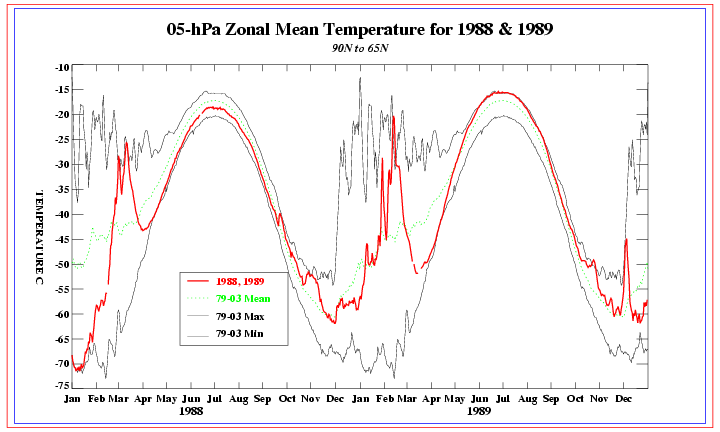
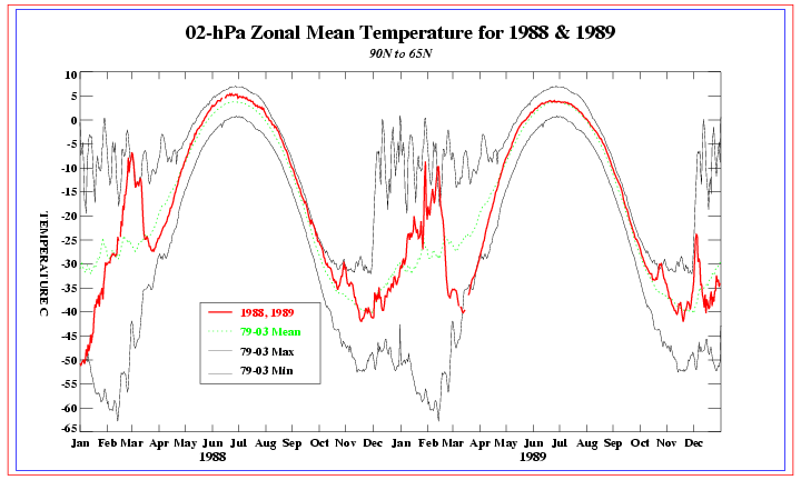
I’m still looking for strat. zonal wind data for 1983 and 1989. In the meantime, I did find the following graph, which is of 65N to 90N zonal mean temperatures at 10 mb in 1988 and 1989. Look on the far right: although there was no major SSW in any of the tables I look at (meaning no reversal of zonal winds at 10 mb), you can see there still was a bit of a stratospheric warming spike centered on ~Dec 1st of 1989 to near a record high for that date: https://www.cpc.ncep.noaa.gov/products/stratosphere/temperature/archive/10mb9065_1989.gif —————— This is even more evident further up at 5 mb and at 2 mb: 5 mb: 15C spike warming centered near 12/1/1989: https://www.cpc.ncep.noaa.gov/products/stratosphere/temperature/archive/05mb9065_1989.gif ————— 2 mb: 15C spike warming centered near 12/1/1989: https://www.cpc.ncep.noaa.gov/products/stratosphere/temperature/archive/02mb9065_1989.gif
-
How many of them have a link they want you to click so they can get subscriptions? Look I don’t doubt there could be a cold/snowy December and many signs are pointing that way, but the “major cold and snow11!111!!” should be met with skepticism.
-

2025-2026 ENSO
40/70 Benchmark replied to 40/70 Benchmark's topic in Weather Forecasting and Discussion
The only unusual element is in the event that the zonal wind actually reverses this early, which is still dubious IMHO. This is the latest example of how online forecasting is more geared towards attracting attention and generating revenue, as opposed to adding actual value. -
Same here - we’ve been stuck at 31.8 with light snow. Looks great though!
-
After a true winter's day two days ago (29/16), it didn't make it below freezing last night and poof, there went our little snow cover. Going to be beautiful the next few days at least.
-
Soon, Barney will come to an eastern US location near you!
-

Winter 2025-2026 Thoughts
MJO812 replied to donsutherland1's topic in Weather Forecasting and Discussion
You might be too low with those numbers if December turns out wintry and cold like the pattern is signaling. Well detailed post though -
The recent cold records across the Southeast occurred at both urban and rural sites. So it was the function of the cold Arctic airmass and not radiational cooling. Since even rural areas of the Northeast that radiate well have been missing the cold records at a similar rate as our more urban areas have.
-
Ray, You have to go to the bottom of this and then choose the winter: http://arctic.som.ou.edu/tburg/products/realtime/strat/ Unfortunately, one can go back only to 1990-1 from this source for some reason even though graphs exist back at least to 1958-9.
-
I have watched so many videos on YouTube stating this is an unusual event unfolding and watch out for major cold and snow in the east coming up.
-

Central PA Fall Discussions and Obs
TimB replied to ChescoWx's topic in Upstate New York/Pennsylvania
Someone who doesn’t get it. Enjoy the new website and the 0.000005 page views per day. -
There may be something else at work which links back pretty far in the human collective experience. We evolved through very cold conditions during ice ages when many didn’t survive the harsh conditions. So the cold was something to be feared in generations since those experiences. Warmer conditions were something to be welcomed following these harsh eras. So we don’t have experience yet as a species of warmth being something to be feared. Instead at least in the U.S, most of our internal migration has been from colder climates to warmer ones. This forum is really in the minority. Since most people outside our forum would be happy if we didn’t really have winters at all. It’s why so many go to Florida during the winters. If you notice an Arctic outbreak or snowstorm usually gets much more media attention than a heatwave. My guess is that this natural disposition is hardwired into us from cold and snow being associated with negative consequences for us.
-
(002).thumb.png.6e3d9d46bca5fe41aab7a74871dd8af8.png)
Central PA Fall Discussions and Obs
ChescoWx replied to ChescoWx's topic in Upstate New York/Pennsylvania
And only 18% before 1955....interesting...not really cyclical climate in action!! LOL!! -
Thanks Don. The failed blocking episodes prior to last year all included an RNA, which makes the "blocking no longer works" commentary even more perplexing (not from you). Last years blocking failed due suppression of course.
-
2025-2026 ENSO
40/70 Benchmark replied to 40/70 Benchmark's topic in Weather Forecasting and Discussion
Larry, what is the link to get that historical 60* mean zonal wind data? Thanks. -

Central PA Fall Discussions and Obs
Mount Joy Snowman replied to ChescoWx's topic in Upstate New York/Pennsylvania
Low of 42 with a rounded-up .01" of rain. -
actually, it has a lot to do with radiational cooling combined with what you said. I’m telling you as somebody that’s been flying these routes for 25 years, they radiate better in the interior southeast than we do here and it isnt unusual to see a place like RDU cooler than LGA in Nov/Dec on clear still nights…until the core of the cold season sets up. You are in front of your computer a lot, take a look at the historical records sir.
-
Incredibly tricky temperature forecasts this weekend. Warm air will be lurking just our south and southwest, but there is increasing concern now that we'll end up on the cooler side of the boundary each day.
-
I for one would welcome a front loaded winter, the last decade has been dominated by truly awful Decembers. From everything I’m seeing and reading, this year could finally buck the trend.


.thumb.JPG.418e8a9a2902ae687ec35ff4bc0e038e.JPG)


