All Activity
- Past hour
-
2.20” in the stratus, 1.95” thru the tipper.
-
1.13" in the Strati. No complaints. 2.68" since 8/1, but there are several CoCoRAHS stations along the coast with <2.00" in that timeframe.
-

September 2025 OBS-Discussion centered NYC subforum
MANDA replied to wdrag's topic in New York City Metro
Picked up .27" last 24 hours. Three day event total = .63". Disappointing but at least no runoff and it all soaked in. Overall the dry pattern continues. Some places drier than others but the overall pattern has been dry. Unless there is a surprise it does not look like the tropics will deliver anything over the next week up this way. -

Central PA Fall Discussions and Obs
pasnownut replied to ChescoWx's topic in Upstate New York/Pennsylvania
TGIF and happy fall yall! Glad the rain is done for now, and looking forward to the weekend-scooter ride w/ another couple tomorrow. Then couch time for PSU tomorrow night. Sunday funday with my Son/Gson/DIL and Eagles. Good times. I hope your weekend is a good one also. -
 After looking at all the data and the runs, even though they are inconsistent, I still feel the most likely outcome is a slow approach to the SE coast and either making it inland or staying just off-shore, but then slowing down/stallings and dumping a lot of rain... The big story is going to be the rain/flooding.
 -
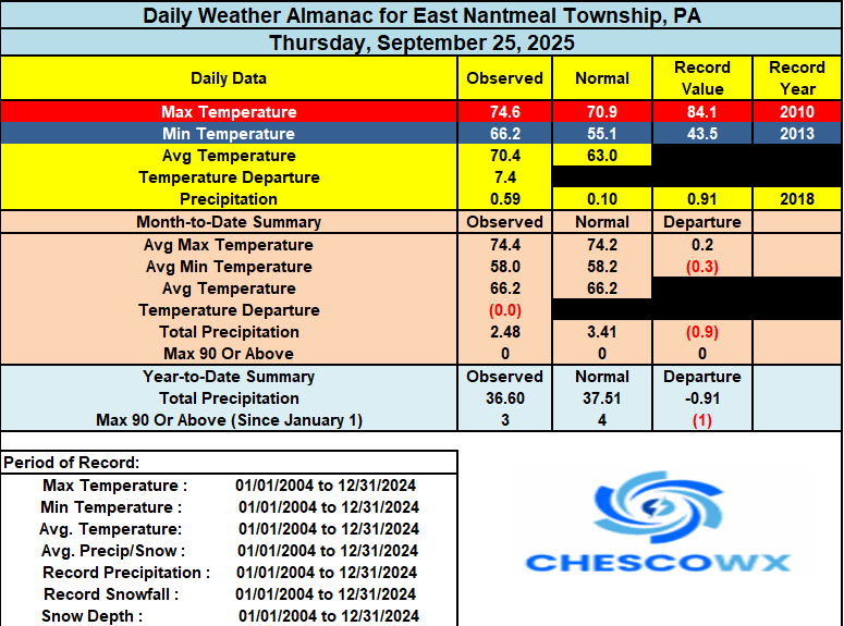
Rain totals over the last 3 days include East Nantmeal 1.22" / Atglen 1.56" / Chester Springs 1.31" / Devault 1.73" / Glenmoore 1.20" / Kennett Square 1.74" / West Bradford 1.64" / Nottingham 0.93"/Warwick 0.57" and West Chester 1.13". We should see some sun today as we dry out and see humidity levels drop. Today should be the warmest day for quite a while. Highs will be well into the 70's to 80 degrees in valley spots. We start cooling down tomorrow and in fact by next Thursday some of the higher spots may struggle to escape the upper 50's for high temperatures. We should see lows well down into the 40's by midweek as we start the month of Red October - Go Phillies! Our only chance of rain looks to be Saturday night with another 0.25" to 0.50" possible.
-
Seems about ready to takeoff
-
(002).thumb.png.6e3d9d46bca5fe41aab7a74871dd8af8.png)
E PA/NJ/DE Autumn 2025 Obs/Discussion
ChescoWx replied to PhiEaglesfan712's topic in Philadelphia Region
Rain totals over the last 3 days include East Nantmeal 1.22" / Atglen 1.56" / Chester Springs 1.31" / Devault 1.73" / Glenmoore 1.20" / Kennett Square 1.74" / West Bradford 1.64" / Nottingham 0.93"/Warwick 0.57" and West Chester 1.13". We should see some sun today as we dry out and see humidity levels drop. Today should be the warmest day for quite a while. Highs will be well into the 70's to 80 degrees in valley spots. We start cooling down tomorrow and in fact by next Thursday some of the higher spots may struggle to escape the upper 50's for high temperatures. We should see lows well down into the 40's by midweek as we start the month of Red October - Go Phillies! Our only chance of rain looks to be Saturday night with another 0.25" to 0.50" possible.
-
2.18" Sent from my SM-S921U using Tapatalk
-
Every storm since winter have been like the Dallas cowboys. All pretty and flashy but total frauds in reality.
-
Since 19-20, he always finds a way to predict a -AO/-NAO winter with a very weak SPV and major blocking every single year. He’s only gotten one right by default….20-21. And I get accused of being biased lol
-
Totaled .15”
-
Ah, rings a bell. I recall it underperforming a bit and angering Richmond too, which made me feel better that others were frustrated (no specific Richmond hate). If I’m getting the details mixed up don’t tell me lol Hopefully we’re tracking something wintry soon
-
welp, the river hardly moved, i'll wait till sunday, but it's not looking good: https://usgs-nims-images.s3.amazonaws.com/timelapse/CT_Connecticut_River_at_Thompsonville/CT_Connecticut_River_at_Thompsonville_720.mp4
-
Virginia Beach.
-
 Overnight ensembles showed more offshore solutions so it will be interesting if the 6z ensembles follow with the OP in showing mostly landfalls
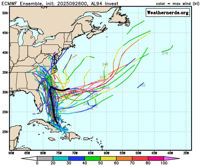
-
Joaquin of 2015 is the one for me.
-
I’m thankful I’ve got a goldfish memory because I’ve already forgot. Is that the one that hit Florida?
-
This is worthy of a ban. I’m STILL traumatized by that one.
-

2025-2026 ENSO
40/70 Benchmark replied to 40/70 Benchmark's topic in Weather Forecasting and Discussion
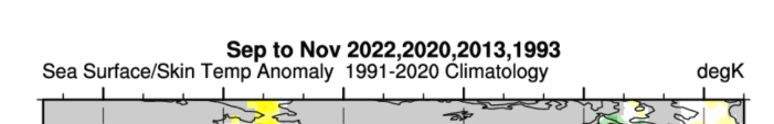
Interesting...a bit of overlap...1993 common denominator. I looked at that season, but ultimately disregarded because there was too much of a warm ENSO flavor to it.
-
2025-2026 ENSO
40/70 Benchmark replied to 40/70 Benchmark's topic in Weather Forecasting and Discussion
I will say that this is not an unreasonable look, and resembles many of the early composites we have seen...but I don't think it's tweaked enough for CC because no way negative anaomalies will be that expansive in a seasonal mean this day and age.....I would snip away the southern and eastern third of that area. -
I've been taking a bottle of campari, a bottle of cocchi sweet vermouth, diced quart of fresh strawberries, 3 scrapped vanilla beans in vacuum sealed bag, sous vide for 3 hours at 125. Strain, chill, Combine 2 oz with 1 oz plantation 114 proof rum over big cube. Sent from my SM-G970U1 using Tapatalk
-
 Still feeling our way around solutions. The 06z Euro brings future Imelda onshore with a similar progression to its other prior runs—much faster than what the 00z had.
 -
-
2025-2026 ENSO
40/70 Benchmark replied to 40/70 Benchmark's topic in Weather Forecasting and Discussion
I always advise taking this guy with a grain of salt, but this is an interesting piece....I consider him like snowman, only on the opposite end of the spectrum. He clearly knows enough to be dangerous, but his data always seems to point in the same direction. https://www.severe-weather.eu/long-range-2/will-north-pacific-ocean-anomaly-bring-cold-winter-2025-2026-united-states-canada-fa/