All Activity
- Past hour
-
-
-
we'll see... I suspect you're seeing the motion on sat, en masse going SW? but this is a legit cold insert behind the weakly defined low moving E of Cape Ann out there over the lower GOM. Already you can see strata streets filling in over Fryeburg and up along the steppe of Maine's interior. I'm curious to see how how much 'clearing' takes place. i'll give it to you though that the day is long and we spend longer time in apex solar so ... there'll be some thermodynamic processing
-
Records: Highs: EWR: 95 (2011) NYC: 96 (1895) LGA: 94 (1987) JFK: 93 (1989) Lows: EWR: 41 (1938) NYC: 46 (1945) LGA: 46 (1945) JFK: 45 (1967) Historical: 1812 - Apple trees at New Haven CT did not blossom until the first of June, the latest such occurrence during the period beginning in 1794. Snow whitened the ground in Cleveland OH and Rochester NY. (David Ludlum) 1903 - A strong tornado just 50 to 75 yards in width killed many persons around the Gainesville GA Cotton Mill. The tornado strengthened and widened near the end of its four mile path, killing 40 persons at New Holland GA. A total of 104 persons were killed in the tornado. (The Weather Channel) 1903: During the early afternoon, one of the most destructive tornadoes in the history of Georgia up to this time, struck the outskirts of Gainesville. The track of the storm was about four miles in length and varied between 100 to 200 feet in width. The tornado touched down about one mile southwest of Gainesville, striking a large cotton mill at 12:45 pm, Eastern Time, just 10 minutes after 750 employees filed into the great structure from dinner. On the top floor of the mill were employed 250 children, and it was here that the greatest loss of life occurred. 1919: Snowfall of almost a half-inch fell at Denver, Colorado. This storm produced their greatest 24-hour snowfall recorded in June. Two temperature records were set: The low temperature of 32 degrees was a record low for the date, and the high of only 40 degrees was a record low maximum. Cheyenne, Wyoming recorded 1.6 inches of snow, which is one of only six times that at least one inch of snow has fallen at Cheyenne in June. 1934: June started off on a warm note as high temperatures surpassed the century mark across parts of the Midwest. Several locations tied or set a record high temperatures for June including: Rockford, IL: 106°, Mather, WI: 105°, Hatfield, WI: 103°, Mondovi, WI: 102°, Chicago, IL: 102° and Grand Rapids, MI tied their June record high with 102°. 1947: Air Force weather flights into Pacific typhoons commenced on this date. (Ref. Wilson Wx. History) 1951: Billings, MT, Sheridan, WY and Miles City, MT recorded their all-time coldest June high temperatures of 36°, 38° & 40° respectively. (Ref. Wilson Wx. History) 1956: Not good to be close to 5,000 lb. of dynamite when it explodes. Lightning “prematurely” exploded that quantity of dynamite at a MA turnpike construction site near Woronoco. 25 men were within 300 feet of the blast epicenter. 5 were hurt; amazingly, no deaths. (Ref. Weather Guide Calendar with Phenomenal Weather Events 2011 Accord Pub. 2010, USA) 1969: For about three seconds, a brilliantly white and apparently spherical ball of fire occurred at tree-top height, vividly lighting the area near the Cabin John Bridge exit of the Capital Beltway in Maryland, just northwest of Washington, DC The eerie phenomenon was ball lightning from a thunderstorm. (Ref. Wilson Wx. History) 1971: 8 inches of snow fell at Rainier Park Ranger Station in Washington state at the 5,427 feet elevation level. This ended up as the final snowfall of the 1970-71 winter season and brought the seasonal snowfall total to 1,027 inches to set a new record for the U.S. Despite this huge amount of snow, even more fell in the 1971- 72 season. (Ref. Wilson Wx. History) 1980 - A man from Falmouth ME was struck by lightning restoring his eyesight. The man had been blind and partially deaf since a truck accident in 1971. (The Weather Channel) 1987 - Severe thunderstorms in the Upper Mississippi Valley and the Lower Ohio Valley produced wind gusts to 81 mph at Albert Lea Airport in southern Minnesota, and baseball size hail around Otterbein IN, Sarona WI, and Danville IL. Two inches of hail totally destroyed 5000 acres of corn and soybean north of Danville. (The National Weather Summary) (Storm Data) 1988 - Thunderstorms drenched north central Texas with torrential rains, with more than 14 inches reported in Commanche County. Afternoon thunderstorm in New Jersey and Pennsylvania produced wind gusts to 70 mph. (The National Weather Summary) (Storm Data) 1989 - Thunderstorms developing during the afternoon over the Southern Plains Region produced severe weather through the evening and the night, spawning nine tornadoes. Thunderstorms produced wind gusts to 80 mph at Alpine TX, and baseball size hail at Balmorhea, TX, Fluvanna, TX, and in Borden County, TX. (Storm Data) (The National Weather Summary) 1990: A violent F4 tornado hit Bakersville Valley in west Texas. The tornado killed two people and injured 21 others. It also removed 300 feet of blacktop asphalt from a paved road and rolled two 90-ton oil tanks a distance of three miles and put them 600 feet up the side of a mountain. Total damage was $35 million dollars. (Ref. Wilson Wx. History) 1991: DCA low temperature is 74° tying a record high minimum then and eighth consecutive record high minimum tied or broken. (Ref. Washington Weather Records - KDCA) 1999: A tornado with an intermittent damage path destroyed 200 homes, businesses, and other buildings in the southern portion of St. James, Missouri. Of these, 33 homes were destroyed along with the St. James Golf Course clubhouse and two Missouri Department of Transportation buildings. The tornado then moved east, south of the downtown St. James area and intensified. F2 to F3 damage occurred with a 200 to 300-yard damage path. Several homes and farm buildings were severely damaged or destroyed. Further north, severe thunderstorms produced many tornadoes around central Illinois. The most intense tornado touched down in Montgomery County south of Farmersville and moved into southwest Christian County. One person was killed when a semi-trailer overturned at a rest area on I-55. Across eastern parts of the state, high winds up to 70 mph caused damage to trees, power lines, and some buildings. The Mattoon area also reported flooding from these storms, producing $3 million dollars in damage. 2002: The high temperature at Denver, CO equaled or exceeded 90° for 13 consecutive days equaling the 5th longest such streak on record. The record of 18 consecutive days was set during the summer of 1901. (Ref. Wilson Wx. History) 2003: Thunderstorm activity well to the northeast of the Eddy and Lea County plains induced a strong mesohigh and associated outflow winds which evolved into a classic kabob wind and dust storm. Radar and surface observations indicate the outflow originated as a complex of weak and disorganized storms moved across the area northeast of Roswell, some 50 miles away from northern Eddy County. Thertesia Automated Weather Observing System measured a wind gust of 74 MPH. Real-time reports, along with subsequent photographs provided by the county emergency manager, indicated a large wall of dust associated with the leading edge of the damaging winds. Power poles were blown down as the winds swept across the west side of Carlsbad, at least 60 to 70 miles south of the parent thunderstorms. (Ref. Wilson Wx. History) 2012: At least 11 tornadoes touched down in Maryland and Virginia during (June 1, 2012 Friday's) storms, according to the latest figures. A severe thunderstorm with a confirmed EF1 tornado, high damaging winds and very heavy rains caused white-out conditions on Friday afternoon, June 1, 2012 in the Finksburg 2NW area. This was the same thunderstorm that affected Mt. Airy and Gamber earlier. Attached are a few photos of the damage. I also have some maps of the damage area NW of Finksburg, Maryland. My rainfall at Manchester 1SW as of 11pm was 3.07" . Storm total was 3.13 inches. No wind damage at Manchester 1SSW.( By Ref. : Herb Close)
-
 Gotta wonder if that's the old Euro mid/long range heat bias kicking in.
 -
It should clear out here in the next couple hours. The mank will work deeper into SNE.
-

2026-2027 Strong/Super El Nino
bluewave replied to Stormchaserchuck1's topic in Weather Forecasting and Discussion
Probably a function of the more Niña-like -PDO with the WPAC warm pool. Plus the ongoing drought. So another case of the 500mb ridges becoming stronger more expansive during the 2020s than we have typically seen in the past.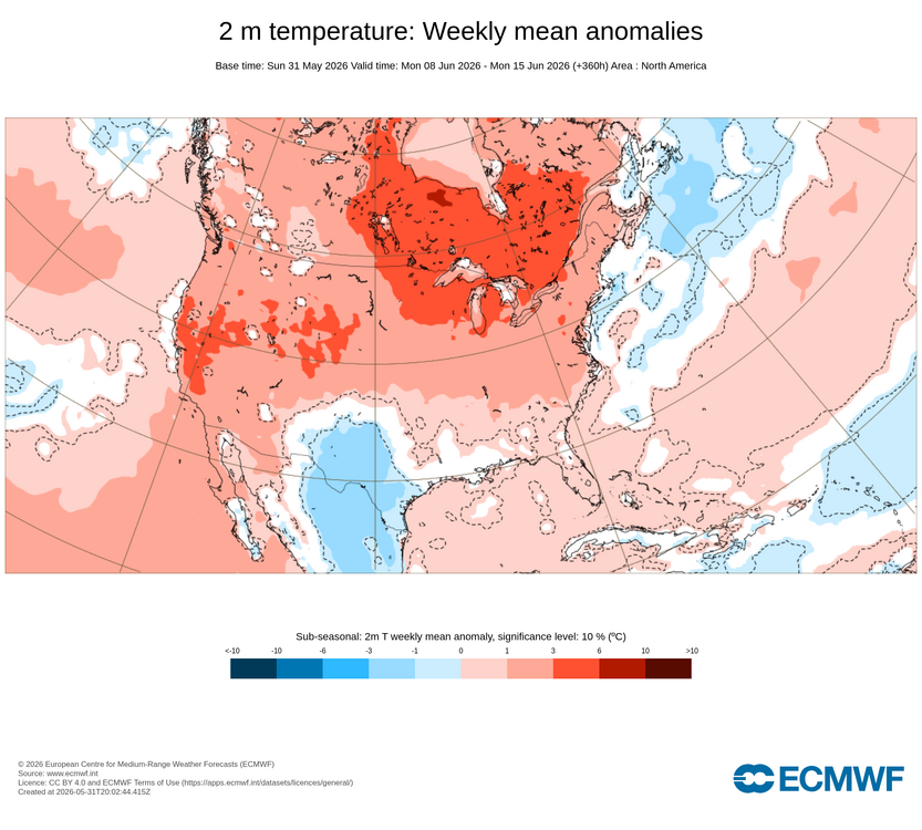
-
Yeah and looking at sfc obs together with morning sat loopage, there's a reinforcing diffused BD slipping SW through the region this early morning
-
From 40 - 80 Sunday. 68 / 49 dry cool open to the week and month. Warming by mid week and Thu with chance of upper 80s low 90s Fri - Sat and the next front trough pushing through Sunday. Overall near to slightly above normal by way of occasional cut offs and onshore and quickrebounds back an forth till about the 14th. Looking warmer beyond there. We'll see how much wetter we turn next week.
-
Beautiful morning here…clear and 55 currently.
-
EWR: + 1.2 JFK: +0.7 LGA: +0.2
-
twisted dark humor aside, we're in some kind of fractal this spring for this dog shit cold pooling (recurrent leitmotif). If it's not synoptic in scale, it's this shit above, even more so relative to our climate - which is bad enough for this in the first place.
-

Central PA Spring 2026 Discussion/Obs Thread
Mount Joy Snowman replied to Voyager's topic in Upstate New York/Pennsylvania
Lows for Friday night through Sunday night were 54, 45, and 52, respectively. I power washed for ten hours straight yesterday and feel like I went ten rounds with Hollyfield. Our stretch of weather bliss continues through this week. Onward. -
this is probably that 15th time this spring I've pondered how in the hell civility decided to footprint this cold atmospheric sewage cistern of planetary region ... It's gonna be 70 in Maine after morning coffee while we're being strapped down in Labrador's rape shack
-
 I hope that map you just posted isn't right! If we get only around a half inch of rainfall thru June 17, we will be in huge trouble around here. We're gonna start seeing wells dry up and wildfires
 -
49° and misery mist. Welcome to the first day of summer.
-
Low of 40 this morning. Absolutely spectacular day yesterday. Pic is of Broadford Lake in Garrett County where we watched a nesting pair of bald eagles for at least an hour.
-
Happy June 1 month closer to Winter
-
Happy June 1 month closer to Winter
-
Cansips have a coastal track for the winter. Lets go !
-
Solar panels been making $$$$$ the last several days
-
Couple of borderline needling OCD observations about tomorrow ( Tues) I would argue that frontal like PP passing thru the region early tomorrow morning is not a cold front. It's more of a warm front, nondescript but qualitatively. It's unusual that the pressure rises behind a warm front, but not impossible. Most importantly, the 850 mb temperatures are rising several degrees over today and tonight, having flooded over lower Ontario upstream, sourcing from the ridge nodal block N of Lake Superior, and about to spill SE - said boundary-like feature demarcates. Tomorrow probably pushes against the ceiling of perfection. It can't actually get there, because ... easy philosophy, perfection is unknowable. What is a 10::10 for any given consensus, is likely to have contrived flaw(s) by TauntonBlizzard2013 ... Or, is thematically operative in a dry dystopian horror film by Michael Bay's buddy, Damage In Tolland. Excluding these fringe tarnishing efforts/aspect, tomorrow will be a text book down slope study case. 800 mb to surface flow is unidirection to the sfc, transporting out of that upstream warmth ... at about 15kts up top to barely noticeable at the surface/valleys. DPs are not appreciably high so thermal absorption into water vapor is low. The mixing layer may stop at 900 or 875 mb, because of +d(PP)/DVM on-going, but this compresses to go along with the d-slope katabatic action. I would go above the 77 MAV/MEX mean. I guess to be fair... there may be some pancake tendencies around noon, but that may be transient while mixing out.
-

E PA/NJ/DE Spring 2026 Obs/Discussion
PhiEaglesfan712 replied to PhiEaglesfan712's topic in Philadelphia Region
May average temperature finishes at 65.6 at PHL, which is 1.3 degrees above the 1991-2020 average (1.7 degrees above the 1981-2010 average). Meterological spring average temperature finishes at 57.8 at PHL, which is tied for the 3rd warmest spring on record (with 1921, and behind only 2010 and 2012). -
Total for May 3.06" rain. Highest temp 93; lowest 39
-
Overall, May was a chilly, near average rainfall month for the Triad, but not uniform. Temperatures averaged 1.7 degrees below normal, rainfall .32” below normal. The coldest temperature was 36 degrees, which meant some in the Triad had a May frost. However, the highest temperature was 92 degrees, which occurred thrice last month. Lately, 90s have been rather unusual in May, but last month had four such days, the earliest on May 18.


.thumb.JPG.418e8a9a2902ae687ec35ff4bc0e038e.JPG)


