All Activity
- Past hour
-

November 2025 general discussions and probable topic derailings ...
klw replied to Typhoon Tip's topic in New England
Proof that it is too soon to say that summer's back is broken! -
This only recently seen on the models cold shot is for the weekend after Thanksgiving. So, this is technically during the last days of Nov. Then I still expect a mainly mild first half of Dec. while the MJO crosses 7 and we wait to see what the SSWE does just afterward. Of course expectations and reality sometimes don’t match well.
-

November 2025 general discussions and probable topic derailings ...
tamarack replied to Typhoon Tip's topic in New England
And semis on the rocks in Chain of Ponds. Addressing the 2002-03 and 2003-04 question: 02-03 was great in SNE but cold and dry here - suppression. Total snow was 75% of average and it's one of only 3 (of 27) winters without a 20"+ month. 03-04 was front-loaded here. The storms of Dec 6-7 and 14-15 totaled 37.1". the rest of the snow season had only 35.5". -
Did the SSW actually happen/still on track to happen?
-
https://twitter.com/IsaacWxObserver/status/1990846704552153573?s=20 EDIT: for some reason link isn't embedding
-
A month from now this would of been a nice 2-4"/3-5" event
-

November 2025 general discussions and probable topic derailings ...
weatherwiz replied to Typhoon Tip's topic in New England
Wasn't there a back-to-back period there where BDL put up like 90" then 70"+? -
Should be the other way around
-
It will come east but modified. Can we get the storm track to our SE instead of a parade of cutters? If I was in the upper TN valley/Ohio valley I would be really excited.
-

E PA/NJ/DE Autumn 2025 Obs/Discussion
RedSky replied to PhiEaglesfan712's topic in Philadelphia Region
ECM 1" line rides northern Lehigh County -

Occasional Thoughts on Climate Change
WolfStock1 replied to donsutherland1's topic in Climate Change
No. -
I'm thinking you might be seeing a rain/snow mix. it's very hard to see that out of your window, but you might see some translucent, very wet flakes if you go outside and analyze
-

November 2025 general discussions and probable topic derailings ...
WinterWolf replied to Typhoon Tip's topic in New England
02-03 was very good…but again not wire to wire. -

Occasional Thoughts on Climate Change
donsutherland1 replied to donsutherland1's topic in Climate Change
The Earth would typically need to see a shift of 0.1° (about 7 miles) or more for an impact on its climate through changes in solar insolation. The reported shift is far less than that. It's essentially meaningless from a climate standpoint. -
November 2025 general discussions and probable topic derailings ...
WinterWolf replied to Typhoon Tip's topic in New England
Kind of figured that was coming….that’s why I asked you this morning what I did. Yes, we take. -
1” at MMU? Not much chatter in the office about any snow coming. Could be a fun surprise.
-
November 2025 general discussions and probable topic derailings ...
WinterWolf replied to Typhoon Tip's topic in New England
It would have been 93-94. That winter was record breaking ln CT. And then So was 95-96. But they both melted out completely at a point. And that’s just it…it’s super rare to not have that happen at some point in SNE. -
True. Actually dropped a bit in last hour, now 38.2/36.1 with that light rain at 2 pm. I am RIGHT on the edge of the precip, and 30 miles south of me as the crow flies it is in the low 50's. NWS says my high is 55 for today, MIGHT make that if the rain clears out and get a little sun, otherwise I'm thinking 44/45.
-
E PA/NJ/DE Autumn 2025 Obs/Discussion
RedSky replied to PhiEaglesfan712's topic in Philadelphia Region
I would say the I78 corridor peeps -

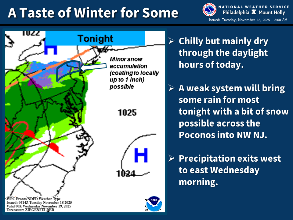
E PA/NJ/DE Autumn 2025 Obs/Discussion
soadforecasterx replied to PhiEaglesfan712's topic in Philadelphia Region
-
The 12z GFS and to some extend the 12z CMC were flirting with an anafront. Worth watching as most modeling is now "seeing" this earlier cold front. Jeff mentioned it in the December thread. But I guess we prob should put the actual storm here(if it occurs).
-
Well below.
-
I mean, he totally went against what the EURO weeklies and the other ensembles were showing run after run for early December and if that should actually happen, maybe he’s onto something?
-

November 2025 general discussions and probable topic derailings ...
weathafella replied to Typhoon Tip's topic in New England
1992-93 was snowy but had some huge torches. The February and March packs were epic however. 1993-94 came close except for a 3 day torch that melted everything but reloaded until winters end. -

December 2025 Short/Medium Range Forecast Thread
Carvers Gap replied to John1122's topic in Tennessee Valley
I don't really do hype. I know the winter weight which Dec 2009 carries. The CPC has been using it to balance out their analog package for a few days. I doubt the entire winter matches this analog, but December(at least the first 2-3 weeks of it) looks like a decent match when compared to ensembles and some LR ext modeling. Kind of uncanny. Two different models with similar outcomes in regards to analog matches. In all reality, those are just MJO matches vs actual analog month matches. That said, pretty sure the QBO was dropping or negative during Dec 09-10.


