
All Activity
- Past hour
-
you're still alive?
-

Spring/Summer 2026 Pattern Discussion Thread
KakashiHatake2000 replied to Carvers Gap's topic in Tennessee Valley
Right I checked again and clouds were still there at 12 and 1 am oh that’s very interesting and good to know didn’t know that actually thanks that’s pretty neat glad you got to see a rare opportunity for meteors Yes I am in discord servers with people in Europe and uk and they were posting photos of the solar eclipse pretty neat stuff yep ikr and same the 2017 one feels like a decade ago almost can you believe it wow Dang another solar eclipse that’s pretty neat in 2027 but yeah unfortunately wish that sort of thing could stop I bet Spain got a lucky treat yesterday sort of like the one maybe in 2017 perhaps not sure the next one won’t be until 2045 I think but that’s in the Deep South Hope that the livestreams and photos online can help that neurotic feeling of the solar eclipse for 12 months were pretty amazing photos videos online from yesterday . -
Yea that was my thought also. Sometimes an average when there are two distinct sub sets within the analogs is the least likely outcome! I get it that some feel pressured to make a definitive forecast but the truth is a good forecast would be to say “we have an elevated risk of a historic snowstorm this winter, it’s going to be wet, but it might end up too warm and in that case a snowless winter and it’s about 50/50 odds”. If people aren’t smart enough to digest some nuance and ambiguity oh well. Fake certainty does no one any good.
-

2026-2027 Record-breaking El Nino
Cobalt replied to Stormchaserchuck1's topic in Weather Forecasting and Discussion
Yeah, the cold was definitely legitimate in the East. NYC for example had a 16 day stretch during effectively peak winter that ranked top 3 coldest, and I believe it was don who also noted that the same site had its coldest La Nina February in 90 years. Impressive metrics in a warming climate.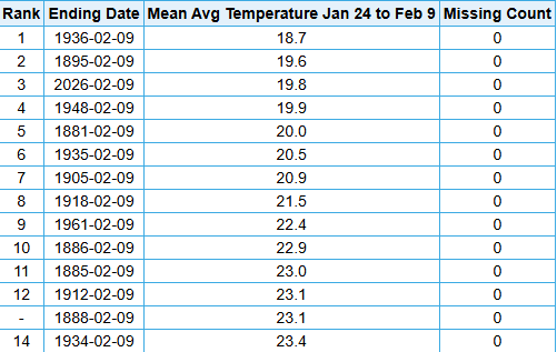
-
So the nw pacific does have leaking molten java from the floor bottom. I got laughed out of the room years ago when I suggested that warming is from the bottom up and not the top down due to puny mankind. The planet is dominated by oceans and ice and about 4 % developed and populated which is ridiculous to suggest cow farts and cars are doing that. The planet is a pot of water and those pots very rarely warm firm the top down
-
 buy medicines online in india or online pharmacy india indian pharmacies safe https://cse.google.com.py/url?sa=i&url=http://trustpharmaindia.com online shopping pharmacy india or https://kamayegaindia.com/user/bsydtmhots/?um_action=edit online pharmacy india [url=https://maps.google.com.sg/url?sa=t&url=https://trustpharmaindia.com]buy prescription drugs from india[/url] top 10 online pharmacy in india and [url=http://www.garmoniya.uglich.ru/user/dlaeiokacz/]Online medicine home delivery[/url] online shopping pharmacy india
 -
buy medicines online in india or online pharmacy india indian pharmacies safe https://cse.google.com.py/url?sa=i&url=http://trustpharmaindia.com online shopping pharmacy india or https://kamayegaindia.com/user/bsydtmhots/?um_action=edit online pharmacy india [url=https://maps.google.com.sg/url?sa=t&url=https://trustpharmaindia.com]buy prescription drugs from india[/url] top 10 online pharmacy in india and [url=http://www.garmoniya.uglich.ru/user/dlaeiokacz/]Online medicine home delivery[/url] online shopping pharmacy india
-

E PA/NJ/DE Summer 2026 Obs/Discussion
Kevin Reilly replied to PhiEaglesfan712's topic in Philadelphia Region
Thanks Paul still some Wildfire smoke upstairs going on. Smoke has been going on for days now. I would like to see the blue skies again instead of the milky whitish blue stuff. -

2026-2027 Record-breaking El Nino
MJO812 replied to Stormchaserchuck1's topic in Weather Forecasting and Discussion
Depends where though . NYC haven't seen a week straight of temps in the 20s in a long time until last winter. -

2026-2027 Record-breaking El Nino
LakePaste25 replied to Stormchaserchuck1's topic in Weather Forecasting and Discussion
i just thought the cold last winter was overhyped. It’s called winter it’s supposed to be cold. -
https://mexisaferx.shop/# best pharmacy in mexico
-
CFS and ECMWF are both pretty cold for core winter. However several other season models are warmer. I suppose if one cranks up the El Nino signal it goes cool South. +PNA would be expected if the PDO gets lined up - still TBD. Then yes the -NAO can happen with forcing downrange and poleward of the Tropics. That's all review for many readers, but with noting. My thinking is that the modeling is not yet coded for such a warm Nino. I figure we flood the atmosphere with warmth across the board. Sadly if the South does get BN temps it might be cloudy crappy days with meh nights. Figure we'll get a few cold weeks, but most of summer I'm thinking blowtorch from El Nino Godzilla.
-
buy medicines online in india or online pharmacy india indian pharmacies safe https://cse.google.com.py/url?sa=i&url=http://trustpharmaindia.com online shopping pharmacy india or https://kamayegaindia.com/user/bsydtmhots/?um_action=edit online pharmacy india [url=https://maps.google.com.sg/url?sa=t&url=https://trustpharmaindia.com]buy prescription drugs from india[/url] top 10 online pharmacy in india and [url=http://www.garmoniya.uglich.ru/user/dlaeiokacz/]Online medicine home delivery[/url] online shopping pharmacy india
-

Spring/Summer 2026 Pattern Discussion Thread
nrgjeff replied to Carvers Gap's topic in Tennessee Valley
Still had high clouds before Midnight. I did not wake up before dawn to check again. Normally I would check at that 3am pee break but I never woke up. I mention times after Midnight because it is our most favorable angle. At 3am the dark side of the Earth is speeding forward. Early evening we face backward. The later times forward face theoretically makes more meteors visible. However the biggest, brightest, longest fireball in my life was mid-evening and not during any advertised meteor shower. Then I saw the total eclipse video from Spain. I'm surprised how impactful it was that late in the day and low in the sky. Wish I'd been there. We are waiting for 2027, Europe and North Africa's eclipse of the century. Some great climo but poor geopolitical risks. Yesterday would have worked really well anywhere in Spain. So, I'll be eclipse neurotic for the next almost 12 months. -

Augdewst 2026: Summer's Last Stand
weatherwiz replied to Prismshine Productions's topic in New England
ehhh 6/10 Get temps up another 10 degrees and dewpoints another 7-10 then we can talk beautiful -
buy medicines online in india or online pharmacy india indian pharmacies safe https://cse.google.com.py/url?sa=i&url=http://trustpharmaindia.com online shopping pharmacy india or https://kamayegaindia.com/user/bsydtmhots/?um_action=edit online pharmacy india [url=https://maps.google.com.sg/url?sa=t&url=https://trustpharmaindia.com]buy prescription drugs from india[/url] top 10 online pharmacy in india and [url=http://www.garmoniya.uglich.ru/user/dlaeiokacz/]Online medicine home delivery[/url] online shopping pharmacy india
-

2026 C and E Pacific tropical activity
WxWatcher007 replied to GaWx's topic in Tropical Headquarters
“On 11 September 1992 Hurricane Iniki scored a direct hit on the island of Kaua‘i. Over a period of only 3 hours, the category 4 hurricane (on the Saffir–Simpson hurricane wind scale; Simpson 1974) caused damage equivalent to the total general fund budget of the state of Hawaii at that time and wiped out the historical profits of the Hawaii homeowners insurance industry.” That is a staggering amount of damage. 1871 looks really bad too based on the descriptions. -
2026 C and E Pacific tropical activity
WxWatcher007 replied to GaWx's topic in Tropical Headquarters
Now that’s a storm. -
Where can I go to make one of these? lol
-
Augdewst 2026: Summer's Last Stand
WxWatcher007 replied to Prismshine Productions's topic in New England
Beautiful summer day out there -
Close, CVG topped out at 70. Only topped out at 70 here, too. Got 1.13" more of rain here yesterday. Now at 5.91" for the month so far, currently the 9th wettest August on record. Top 10 Wettest Augusts (KDAY) 1. 8.03" - 1974 2. 7.95" - 1979 3. 7.54" - 1995 4. 6.98" - 1978 5. 6.64" - 1912 6. 6.59" - 1926 7. 6.42" - 1982 8. 6.40" - 2001 9. 5.91" - 2026 (as of 8/12) 10. 5.56" - 1906
-
I'll b waitin
-
(002).thumb.png.6e3d9d46bca5fe41aab7a74871dd8af8.png) Mike, this is in my view the most useful thing anyone has put in this thread, and it changes my position on several points. Thank you for doing the archival work rather than just asserting it. Taking your points in order. You're right that "undocumented" in the algorithm's metadata linkage is not the same as "no documentation exists." I was treating the two as equivalent and that was a wee bit sloppy. Your figure shows some actual events behind most of the Coatesville breaks, and the burden argument is fair — I shouldn't claim an absence of records without going through the 530-1s, the deeds and the aerials first. I hadn't. You had - thanks!. You're also right that a high rate of undocumented detections is expected from a detector built to catch undocumented changes, so the 86% figure doesn't carry the weight I was giving it. I'd already dropped that argument after NCEI sent me their changepoint list for this station — it shows 4 of 12 linked to documented events, not zero, so the Berkeley code counts were never a good proxy for what the PHA is doing. On the ramp point: Mike - you're right - many small stacked breaks produce a ramp-shaped cumulative. I proved your point without meaning to — cumulating NCEI's twelve discrete changepoints gives a series that fits a straight line at r-squared 0.495. That's a stack of steps looking smooth, exactly as you say. Zero-adjustment stations and the diurnal range point are both fair points also. A detector leaving clean stations alone is working, and DTR divergence is a studied phenomenon rather than a contradiction. And I accept that a handful of stations in one county is a noisy sample by nature. Now a couple things I will push back on a little, not on it's substance but on how firmly you state it. Your own figure marks 1920 unresolved. And I'd read the 1959-1976 group differently to the header on it. The box says five breaks, but NOAA only has two in that window — 1959 and 1971. The other three are BEST-only. And BEST's five nearly cancel: -0.50, +0.37, +0.02, +0.72, -0.71 comes to -0.10 F net across seventeen years, which isn't doing much work. NOAA's two come to +0.40 F, and that's the direction you'd correct for spurious cooling, not for a station warming under encroaching infrastructure. Which brings me to the part I can't pull together. The station moves to progressively cooler sites implies the raw acquires spurious cooling and needs the later data warmed — which matches what NOAA applied. Infrastructure growing up around the site implies the opposite. Both are in your account of this window. Which one do you think is actually driving it? For what it's worth, your 1959 and 1971 values match NCEI's changepoint list for this station exactly once converted — -0.54 and +0.94 F against -0.28 and +0.53 C. So we're working from the same PHA output, which is worth knowing! Thanks again Mike!! That window also stops something I was about to post. I ran a segmented breakpoint analysis on the raw daily data and it attributed only one concordant discontinuity to Coatesville, January 1973. I then fitted the 1952-82 trend with that single step in the model. If there are more real breaks in that window, my model is under-specified and the number isn't worth quoting. I'm going to refit it against the full break set before I use it. If it doesn't survive, I'll say so here. Stay tuned for that later! The one thing still open is narrower and comes out of NCEI's own files rather than the station history. Cumulating their twelve changepoints reproduces +0.123 C/decade of adjustment trend. The actual adjusted-minus-unadjusted trend for the same station and years is +0.184. About a third isn't in any listed changepoint. It isn't rounding, and it isn't run-to-run variation — I compared two pulls of the adjusted series two days apart and they were identical across all 119 years at West Chester. I've asked NCEI what accounts for it rather than guessing, and I'll post their answer either way. I sent the email this morning to my contact there...stay tuned for more of that later! Now my ask - would you be willing to share your compiled 530-1 and deed work for Coatesville, and whatever you have for West Chester? I'd rather build on it than duplicate it badly, and I'll take your point about the 1978, 1982 and 1988 West Chester breaks — the Daily Local should have left a trail worth chasing. Charlie, I think most of the above answers you as well. You were right that a 35-year regression is not a breakpoint test, and running it properly is what led here. On 1945-49 specifically, NCEI's list has a documented move at 1946-01 with a +0.79 C step, so something documented did happen there. I still can't test that window myself — only three Chester County stations cover 1930-1975 with continuity and attribution needs four — so at this point we can't claim it either way. Paul
Mike, this is in my view the most useful thing anyone has put in this thread, and it changes my position on several points. Thank you for doing the archival work rather than just asserting it. Taking your points in order. You're right that "undocumented" in the algorithm's metadata linkage is not the same as "no documentation exists." I was treating the two as equivalent and that was a wee bit sloppy. Your figure shows some actual events behind most of the Coatesville breaks, and the burden argument is fair — I shouldn't claim an absence of records without going through the 530-1s, the deeds and the aerials first. I hadn't. You had - thanks!. You're also right that a high rate of undocumented detections is expected from a detector built to catch undocumented changes, so the 86% figure doesn't carry the weight I was giving it. I'd already dropped that argument after NCEI sent me their changepoint list for this station — it shows 4 of 12 linked to documented events, not zero, so the Berkeley code counts were never a good proxy for what the PHA is doing. On the ramp point: Mike - you're right - many small stacked breaks produce a ramp-shaped cumulative. I proved your point without meaning to — cumulating NCEI's twelve discrete changepoints gives a series that fits a straight line at r-squared 0.495. That's a stack of steps looking smooth, exactly as you say. Zero-adjustment stations and the diurnal range point are both fair points also. A detector leaving clean stations alone is working, and DTR divergence is a studied phenomenon rather than a contradiction. And I accept that a handful of stations in one county is a noisy sample by nature. Now a couple things I will push back on a little, not on it's substance but on how firmly you state it. Your own figure marks 1920 unresolved. And I'd read the 1959-1976 group differently to the header on it. The box says five breaks, but NOAA only has two in that window — 1959 and 1971. The other three are BEST-only. And BEST's five nearly cancel: -0.50, +0.37, +0.02, +0.72, -0.71 comes to -0.10 F net across seventeen years, which isn't doing much work. NOAA's two come to +0.40 F, and that's the direction you'd correct for spurious cooling, not for a station warming under encroaching infrastructure. Which brings me to the part I can't pull together. The station moves to progressively cooler sites implies the raw acquires spurious cooling and needs the later data warmed — which matches what NOAA applied. Infrastructure growing up around the site implies the opposite. Both are in your account of this window. Which one do you think is actually driving it? For what it's worth, your 1959 and 1971 values match NCEI's changepoint list for this station exactly once converted — -0.54 and +0.94 F against -0.28 and +0.53 C. So we're working from the same PHA output, which is worth knowing! Thanks again Mike!! That window also stops something I was about to post. I ran a segmented breakpoint analysis on the raw daily data and it attributed only one concordant discontinuity to Coatesville, January 1973. I then fitted the 1952-82 trend with that single step in the model. If there are more real breaks in that window, my model is under-specified and the number isn't worth quoting. I'm going to refit it against the full break set before I use it. If it doesn't survive, I'll say so here. Stay tuned for that later! The one thing still open is narrower and comes out of NCEI's own files rather than the station history. Cumulating their twelve changepoints reproduces +0.123 C/decade of adjustment trend. The actual adjusted-minus-unadjusted trend for the same station and years is +0.184. About a third isn't in any listed changepoint. It isn't rounding, and it isn't run-to-run variation — I compared two pulls of the adjusted series two days apart and they were identical across all 119 years at West Chester. I've asked NCEI what accounts for it rather than guessing, and I'll post their answer either way. I sent the email this morning to my contact there...stay tuned for more of that later! Now my ask - would you be willing to share your compiled 530-1 and deed work for Coatesville, and whatever you have for West Chester? I'd rather build on it than duplicate it badly, and I'll take your point about the 1978, 1982 and 1988 West Chester breaks — the Daily Local should have left a trail worth chasing. Charlie, I think most of the above answers you as well. You were right that a 35-year regression is not a breakpoint test, and running it properly is what led here. On 1945-49 specifically, NCEI's list has a documented move at 1946-01 with a +0.79 C step, so something documented did happen there. I still can't test that window myself — only three Chester County stations cover 1930-1975 with continuity and attribution needs four — so at this point we can't claim it either way. Paul -
Some steady light anvil rain with some distant thunder. Pretty cool looking comma head on the radar in Iowa earlier.
-
Well that does seem like the 2 options. Probably no middle ground, so weird that he sorta averaged them together lol









