All Activity
- Past hour
-

2026-2027 Record-breaking El Nino
michsnowfreak replied to Stormchaserchuck1's topic in Weather Forecasting and Discussion
Bookmarked it! Looks great! Just one question, any idea why the CANSIPS seasonal looks quite different than on tropical tidbits? -
I’d expect the Nino will push around the NPac and at least bring the PDO more toward neutral if not weakly positive.
-
2026-2027 Record-breaking El Nino
michsnowfreak replied to Stormchaserchuck1's topic in Weather Forecasting and Discussion
Troll comments arent even worth a response. If there is a +10F month, I cant see how it's anything other than December. It wouldnt shock me knowing the history of strong Ninos, but it seems a low chance the way everything looks now. Regardless of actual departures, Id put money on December being the warmest month relative to avg, not just of the winter, but the entire cold season. -
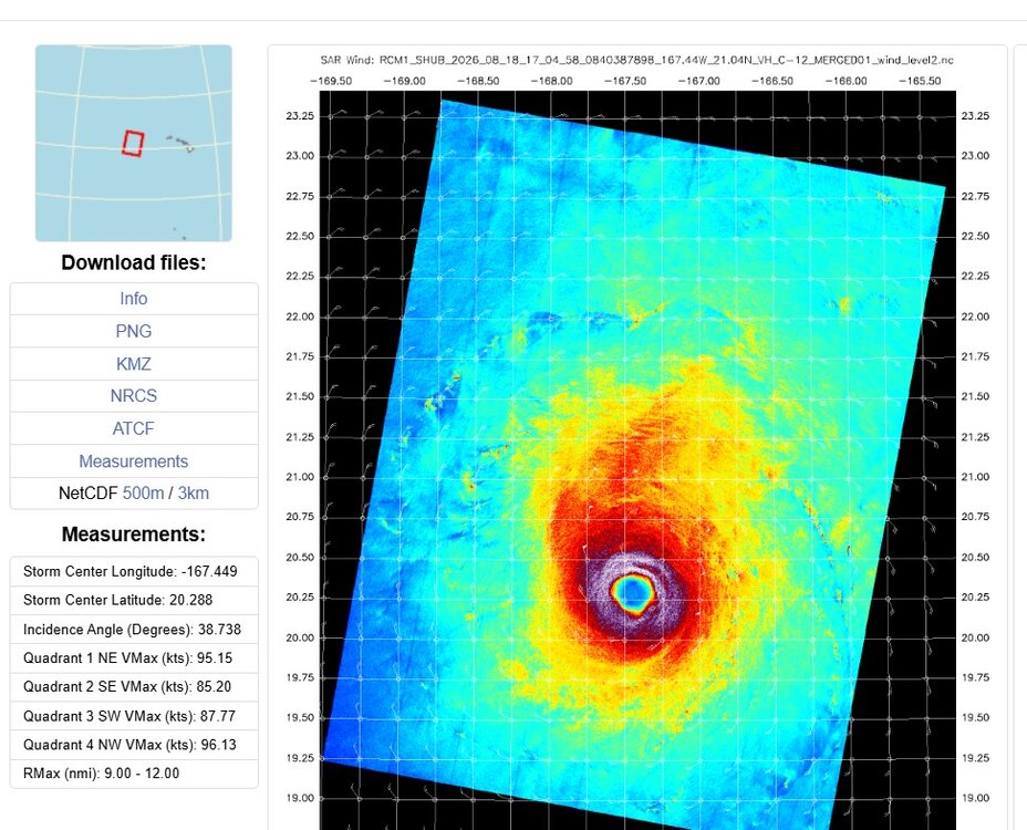
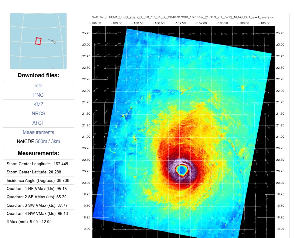
1704z SAR pass shows Lala is near MH strength. 96 kt and well-defined eye. When the day comes when SAR sensors are on geostationary satellites, that will be an immense advancement for remote TC sensing!
-
2026-2027 Record-breaking El Nino
michsnowfreak replied to Stormchaserchuck1's topic in Weather Forecasting and Discussion
The Marquette example was just sort of a fun stat of what can and does happen in the far north. Certainly not a projection for anyone lol. For me, being in the Great Lakes region but outside the heavy snow belts, theres no question that "deep winter" needs average to below average temps to maintain a constant snowpack, thick lake ice, etc. Last year is an absolute textbook example. Well above avg snowcover and below avg temps gave us a severe winter despite actual snowfall finishing around 90% of average (was on pace for better but March fell totally flat). But actual total snowFALL is really dependent on how a season goes. It's a long window from November to April to get snowstorms, so its quite feasible to get average snowfall (40-45") with above to well above avg temps. Pretty much getting over 50", however, tends to require near normal (or below) temps. -
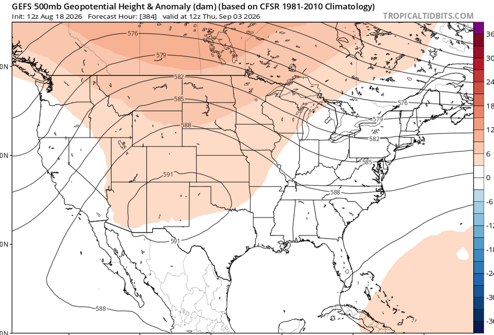
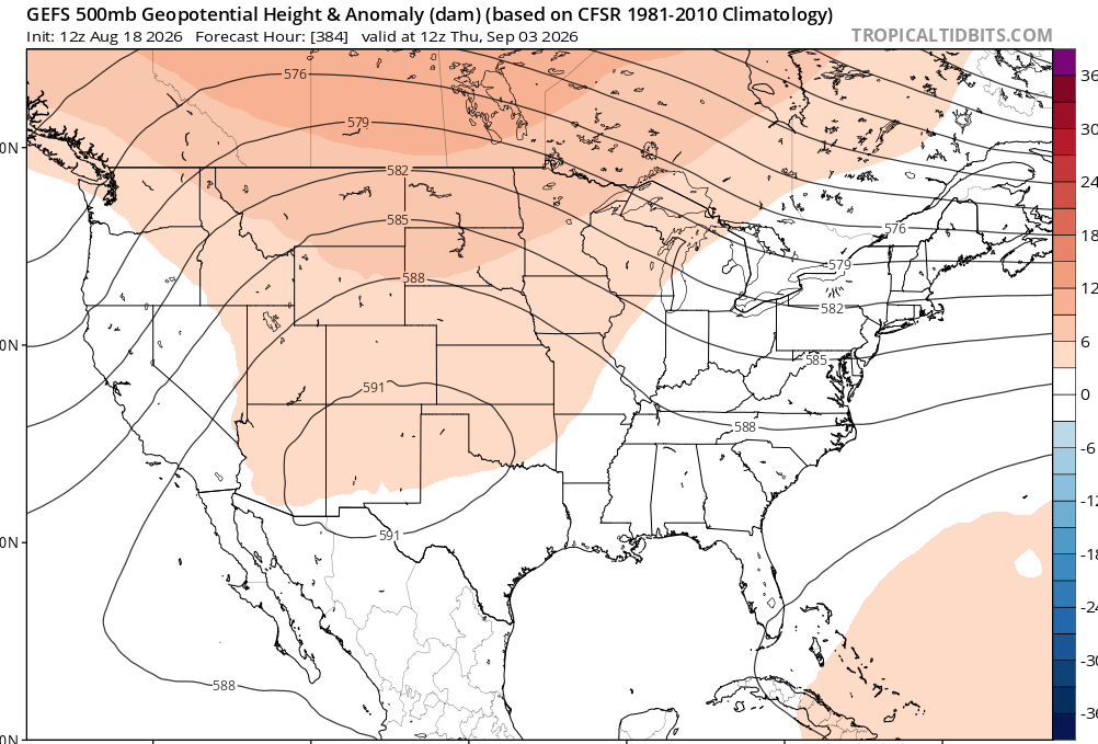
this look is proving somewhat resilient
-
Yeah. I'm more concerned with home growns this year . Not necessarily hurricanes either. Tropical systems that can form in the GOM, even weak ones, this year are going to be loaded water guns moving inland. While El Nino's usually cut down on overall numbers, they usually load up weaker storms. And we certainly don't want a GOM system riding up the MS river this year after what just happened. We're going to be flood prone for the next month with no rain. Rivers and creeks are still in Moderate to Major flood stages. If you stop and walk up to a corn or soybean field theres a lake under most of them.
-

2026-2027 Record-breaking El Nino
Ephesians2 replied to Stormchaserchuck1's topic in Weather Forecasting and Discussion
-
bailed on that storm that went through Urbana like 90 minutes before the tornado after the parent cell didn't have any lightning or hardly any IR presentation. had a great dinner in centerville while the tornado was otg, no regrets
-
warm and rainy
-
88 before now down to 85. Beautiful
-
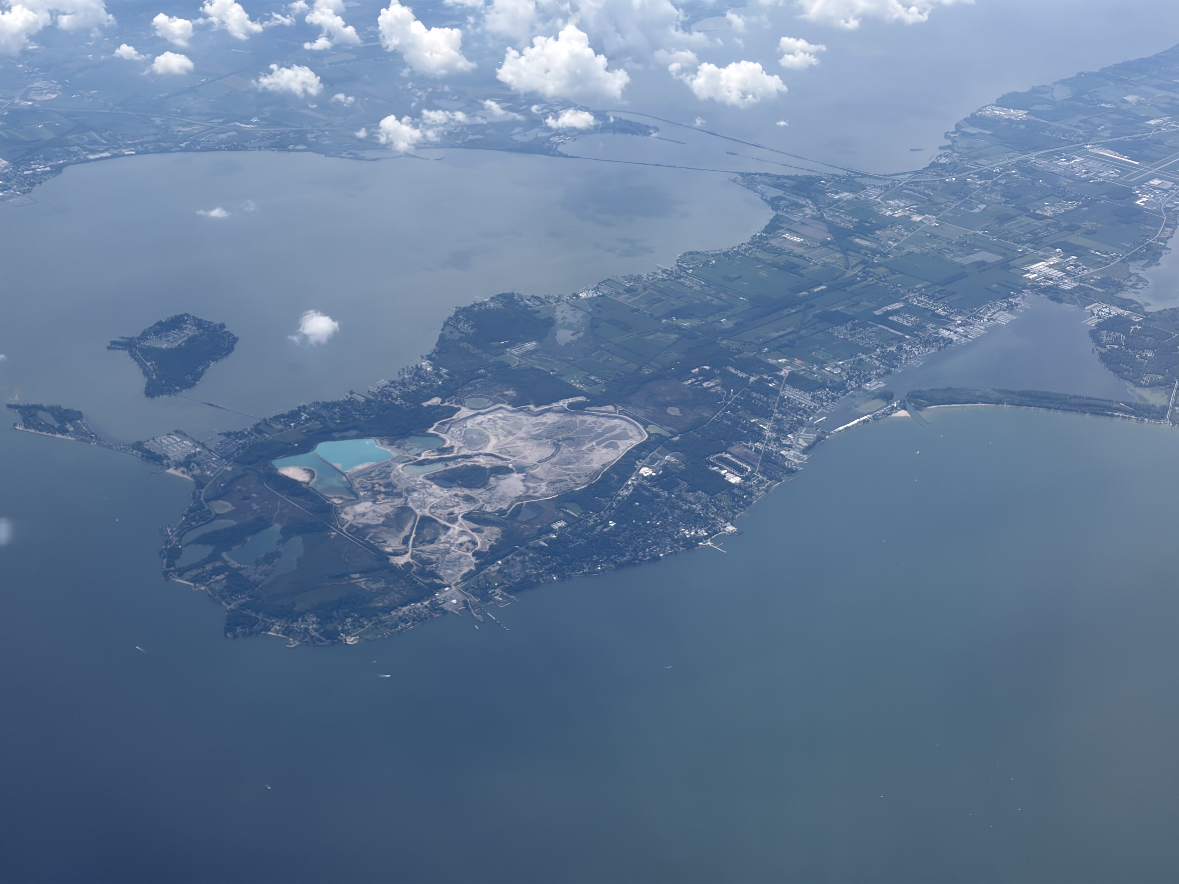
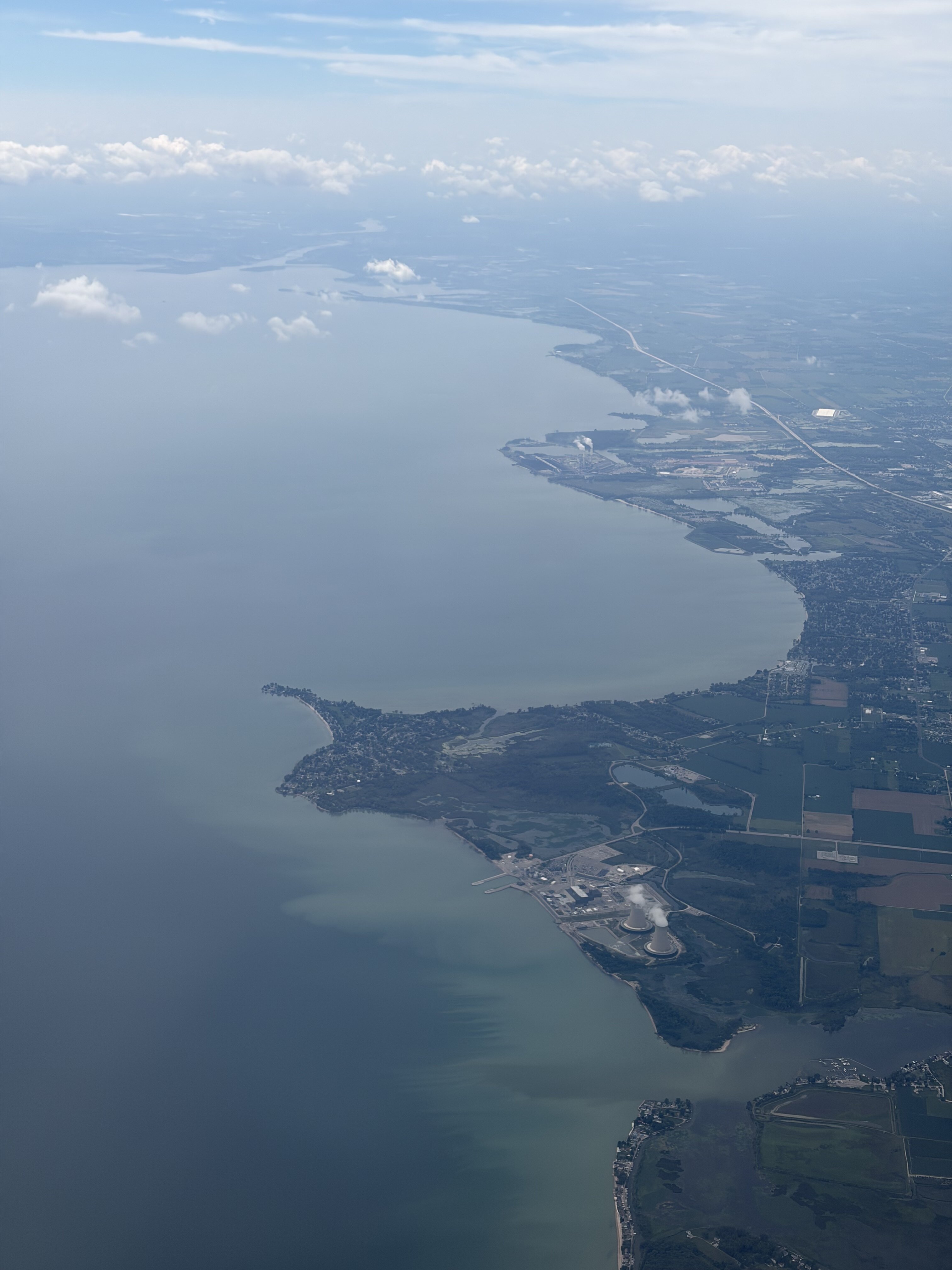
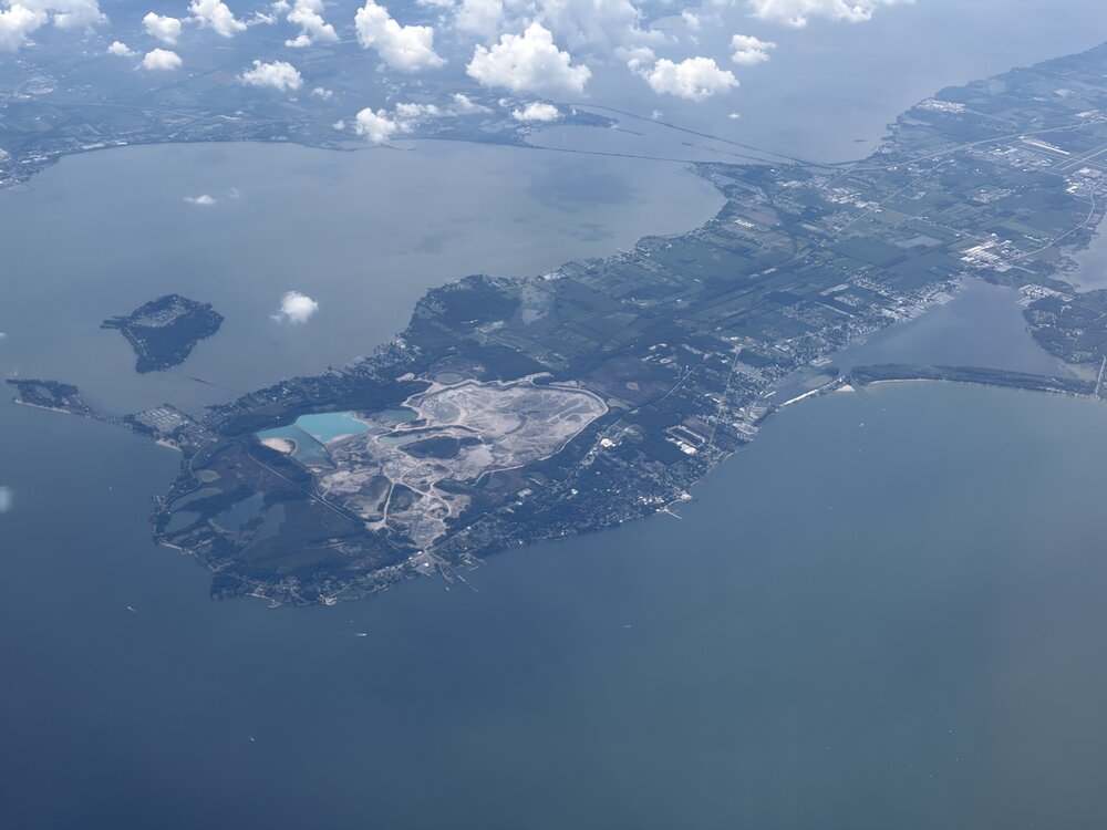
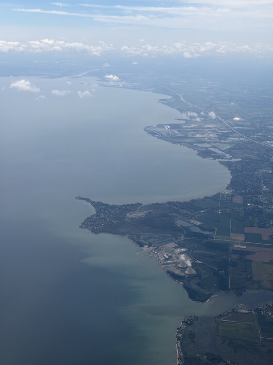
Flying today for the first time in over a decade! Especially because I haven’t flown in so long, flying is still fascinating to me and I’m always at a window looking out! On way to CO, 1st stop is in Detroit, my first time in Michigan. The views of W Lake Erie, my first time seeing Erie, were awesome. Noting the fair wx cumulus over land areas due to heating in the early afternoon while mainly clear over the cooler lake: @roardog@michsnowfreak
-
It's not unreasonable to be pessimistic on snow chances in winter anymore, especially south of 40N. We've been in such a long term snow drought that it's almost safer to forecast Above Normal temps and Below Normal snowfall. You stand a good chance of being right most years outside of New England. Heck, I could see this being a shutout in the snowfall department south of DC this winter. Several folks on here appear to have already punted December and the first half of January!
-
It's an "easy" enso setup to make some decent predictions if you just look at the Nino regions. Where I'm getting hung up is the Npac. There is so much warmth throughout the pac basin that it makes me far less confident predicting standard strong nino conditions. But given the strength of the nino, its hard to bet against a wet southern stream. Its still only August but if the Npac/pdo regions continue to be the opposite of what we really want to see, my gut says this winter will do some weird things that few expect/predict. The pessimistic side of me thinks the pac will overwhelm north America and it will be warm and wet with few chances at good snowfall even to our north and west. The optimistic side of me says we're in a long term HL blocking period and even the EPO will punch cold to very cold air into the conus with a suppressed/favorable southern stream. Meaning the winter could be unusually cold east of the Rockies for a strong nino. I would be pretty funny if its a dry winter though. Maybe the southern stream cuts well west of us or stays south of the gulf coast lol
- Today
-
0.23" last night at the co-op brings me to 0.33" MTD. Got ya beat for what it's worth. Flood Bay precip observer has 0.26" for MTD of 0.46". Cyclone hole shifted N.
-
2026-2027 Record-breaking El Nino
BlizzardWx replied to Stormchaserchuck1's topic in Weather Forecasting and Discussion
It's been a lot of work setting it up, let me know if there is anything you want added. I'm open to requests and it helps all of us to have better tools. I'm going to have to think about this to deeply understand but I think I like this idea! If I can figure out a way to automate it I'll add it to the site. -

Augdewst 2026: Summer's Last Stand
CT Valley Snowman replied to Prismshine Productions's topic in New England
Yeah pretty sure he did. Maybe not the absolute worst but bad enough. -

2026-2027 Record-breaking El Nino
40/70 Benchmark replied to Stormchaserchuck1's topic in Weather Forecasting and Discussion
Oh, pretty please...this would represent an interplanetary orgie for me. Don't get me wrong, I'm sure it will come with some unforeseen, dystopian (as John would say)externality, but we are getting those anyway with the hockey-stick rate of CC, so what the hell...may as well get some snow and cold on the way to meeting our collective maker. -
Quickly to 89 here
-

2026-2027 Record-breaking El Nino
csnavywx replied to Stormchaserchuck1's topic in Weather Forecasting and Discussion
Might be sooner. In a separate interview the author said it may start earlier with the sub-polar gyre and we're already hugging the upper end of the equiv. warming rates in the paper. -
2026-2027 Record-breaking El Nino
40/70 Benchmark replied to Stormchaserchuck1's topic in Weather Forecasting and Discussion
I'll take the over on "barely any snow" in Michigan this coming winter, but a +10 month would not shock me. -

Augdewst 2026: Summer's Last Stand
dendrite replied to Prismshine Productions's topic in New England
He used to post the “Steffi” here from time to time. -

2026-2027 Record-breaking El Nino
LakePaste25 replied to Stormchaserchuck1's topic in Weather Forecasting and Discussion
that’s why super ninos all have below normal snow here. Every month is usually greater than +3. No room for week+ long lake snow blitz’s to save the season. -
2026-2027 Record-breaking El Nino
LakePaste25 replied to Stormchaserchuck1's topic in Weather Forecasting and Discussion
Here as well, at least on a daily basis. +3 or +4 in the monthly is probably the upper limit here where I can get a week of big lake snows while the rest of the month is a torch. Higher than +4, we’re getting into “the whole month is shot outside of a some minor/medium snowfalls” territory.





.thumb.jpg.ad3a2e31d30aff035044689b311a0540.jpg)