All Activity
- Past hour
-

December 2025 regional war/obs/disco thread
WinterWolf replied to Torch Tiger's topic in New England
Obviously we don’t…it’s morphing each day. We laugh..but it’s the truth. A couple days ago, a coastal wasn’t even entertained. Now it’s a possibility…there ya go. We didn’t know. And sure it can all shit the bed, but at this juncture, we don’t know. -

December 2025 regional war/obs/disco thread
WxWatcher007 replied to Torch Tiger's topic in New England
What I love is how the model hopium triggers amnesia—masking the fact that we’ve been on the cusp of epic pattern many times before in this decade. Better this than seeing Canada torched and a stationary trough to Baja. No doubt about that. -
The Canadian high on the 06z Euro is a tad east for my liking. That setup can erode the CAD situation with prolonged southeast winds. Would like to see that backed up further west into the St. Lawrence River Valley.
-
We just don’t know?
-
December 2025 regional war/obs/disco thread
WinterWolf replied to Torch Tiger's topic in New England
Sure..but it’s not currently, and wasn’t yesterday either. -

Central PA Fall Discussions and Obs
Blizzard of 93 replied to ChescoWx's topic in Upstate New York/Pennsylvania
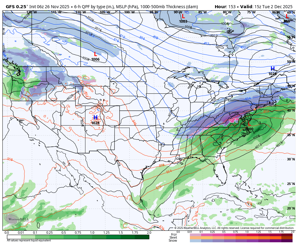
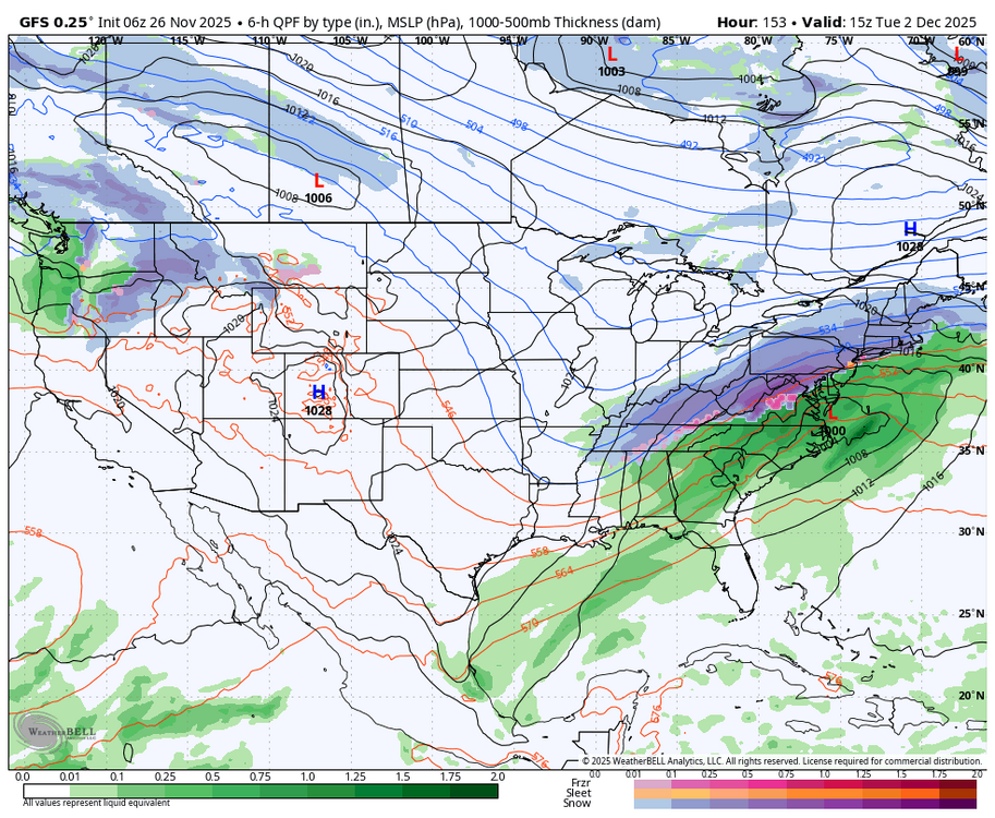
This 6z GFS for mid next week is real nice. Let’s hope 12z continues in this direction.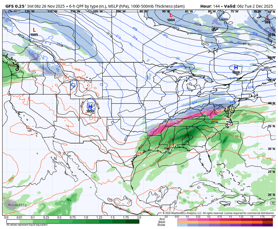
-
Hahahahahaha I’m open to other suggestions
-
December 2025 regional war/obs/disco thread
WinterWolf replied to Torch Tiger's topic in New England
Kev…no, you were trolling yesterday, looking for info, and entertaining that silly poster TT. Scott posted his potential concerns(which were valid), and then you came with the BS I posted above. Nothing was slipping away yesterday, and you knew that, or should have. Let’s do away with that crap..forum is a much better place without that shit. -
Its rather easy to see why it would occur - that HP has to stay in place and block the storm into a favorable path for I-95 and provide the cold air source and be in a position to restrict the onshore warmer winds off the ocean - concentrate on the HP positioning
-
Still could lol
-
Reported 4.0" this morning here in town. Blew around, and drifted some, so took multiple measurements. 7" reports last night along the higher terrain. Should be a little higher when the reports flow in. So the my 4" thinking did come to pass for town. Looks like LES just to my NE with a nice band over N WI. Probably just some snow showers left for me today.
-

Nov 28-30th Post Turkey Day Wintry Potential
cyclone77 replied to Chicago Storm's topic in Lakes/Ohio Valley
A lot of folks will be putting up their Christmas trees Fri-Sat so this will be like movie like timing for that lol. -

November 2025 general discussions and probable topic derailings ...
dendrite replied to Typhoon Tip's topic in New England
Thu but it only goes through yesterday. We're well below normal precip this month even with last night's rain. -
Can we just score one early for once that would be amazing.
-

December 2025 regional war/obs/disco thread
HoarfrostHubb replied to Torch Tiger's topic in New England
It’s got a heartbeat at least
-

December 2025 regional war/obs/disco thread
Damage In Tolland replied to Torch Tiger's topic in New England
All good news . Hopefully everyone cashed in on Tuesday and we don’t lose it. For Wolfie.. snow threats and as of now it’s not slipping away -

Nov 28-30th Post Turkey Day Wintry Potential
A-L-E-K replied to Chicago Storm's topic in Lakes/Ohio Valley
that was such a sick event for you -
Absolutely. And wrt the 850's, the 6z now has that classic drainage down the eastern side of the Apps that was missing at 0z.

-

November 2025 general discussions and probable topic derailings ...
Lava Rock replied to Typhoon Tip's topic in New England
0.59" overnight. when's the next drought monitor update? -
December 2025 regional war/obs/disco thread
WinterWolf replied to Torch Tiger's topic in New England
Selective memory isn’t good either…

-

Nov 28-30th Post Turkey Day Wintry Potential
King James replied to Chicago Storm's topic in Lakes/Ohio Valley
I’m about a foot of snow ahead of most of you so feels like I have to just watch this one and hope someone cashes in. Even 4 inches for me would be a steal. I’ll go 3.1 inches final call. -
Yeah the main show looks mostly on Tuesday as presently modeled. But this is kind of a delicate look with the timing of the southern energy. We’re gonna want this to hold serve for a couple more days before confidence increases a lot. The good news is even if that threat craps out, it looks good for additional threats behind it. Overnight longer range guidance has become a little more aggressive in retrograding the Scandinavian ridging into northern Greenland which in conjunction with a bit more amped WPO ridge, is producing a colder look into mid-December.
-
Winter 2025-26 Medium/Long Range Discussion
A-L-E-K replied to michsnowfreak's topic in Lakes/Ohio Valley
would be nice to get the high ratio duster mid week to trend favorably -

December 2025 regional war/obs/disco thread
moneypitmike replied to Torch Tiger's topic in New England
I told my wife that we'll never have snow at our new Pit1. It would be funny if she's calling me a liar in the first week of December. Bring that up to Pit2. -
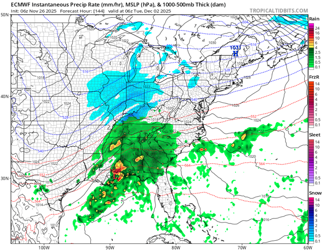
6z euro def better than 0z thru 144. So that’s something.