All Activity
- Past hour
-

“Cory’s in NYC! Let’s HECS!” Feb. 22-24 Disco
Damage In Tolland replied to TheSnowman's topic in New England
The scrapes are still a snowstorm -

Feb 22nd/23rd "There's no way..." Storm Thread
paxpatriot replied to Maestrobjwa's topic in Mid Atlantic
We’re 3 days out. If the GFS is light years off at this point, might be time for a toaster in the bath for it. -

“Cory’s in NYC! Let’s HECS!” Feb. 22-24 Disco
CoastalWx replied to TheSnowman's topic in New England
00z euro ai was nice in that it didn’t mature east of Wallops Island. Kind of did that to the ENE. -
.thumb.jpg.6a4895b2a43f87359e4e7d04a6fa0d14.jpg)
Central PA Winter 25/26 Discussion and Obs
Yardstickgozinya replied to MAG5035's topic in Upstate New York/Pennsylvania
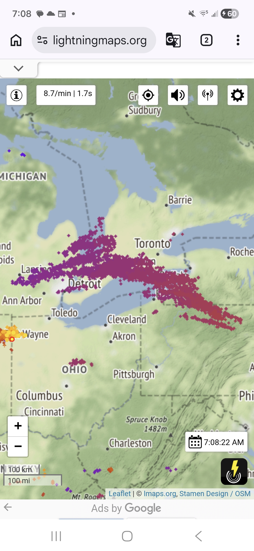
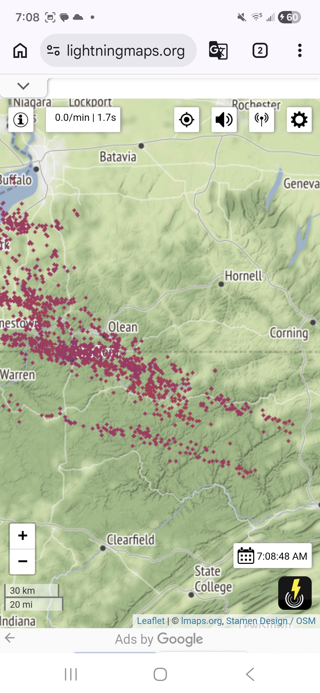
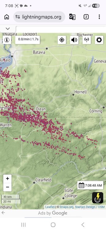
I just went back and checked these storms out. It definitely was a impressive cluster all things considered. It started putting down lightning in Charlotte Michigan and didn't stop putting down consistent strokes until somewhere around State Gamelands, 114 in the Northern Allegheny Plateau.
-

“Cory’s in NYC! Let’s HECS!” Feb. 22-24 Disco
RUNNAWAYICEBERG replied to TheSnowman's topic in New England
And UK, igone, nam….i mean it’s not just the euro. Cmc scrapes too. -

“Cory’s in NYC! Let’s HECS!” Feb. 22-24 Disco
Sey-Mour Snow replied to TheSnowman's topic in New England
Honestly I don’t think anyone trusts it I know I don’t, I think it’s more our dumb luck, it’ll finally catch a bone and be 100% right just to F us again. I'm thinking 25% chance big hit 50% light to mid snow 25% compete whiff -

Winter 2025-26 Medium/Long Range Discussion
DocATL replied to michsnowfreak's topic in Lakes/Ohio Valley
The meltdowns will be glorious. . -

Feb 22nd/23rd "There's no way..." Storm Thread
Scraff replied to Maestrobjwa's topic in Mid Atlantic
Good morning everyone! Based on my expertise throughout the years, and the knowledge I have gained by spending hours in this madhouse of a forum, I am 100% positive of one thing: It’s going to snow….somewhere. -
“Cory’s in NYC! Let’s HECS!” Feb. 22-24 Disco
CoastalWx replied to TheSnowman's topic in New England
Squatting the GFS until my legs fell off. -

Feb 22nd/23rd "There's no way..." Storm Thread
Terpeast replied to Maestrobjwa's topic in Mid Atlantic
Not a fan of euro for mby but its probably closer to being correct -
“Cory’s in NYC! Let’s HECS!” Feb. 22-24 Disco
Damage In Tolland replied to TheSnowman's topic in New England
It’s the op Euro vs the world. Pretty dangerous basket for all your eggs -
00z ukie and 6z icon were misses. But yeah I don’t think anyone is hedging toward the euro op?
-

“Cory’s in NYC! Let’s HECS!” Feb. 22-24 Disco
SouthCoastMA replied to TheSnowman's topic in New England
The Euro seems cooked, despite the aggregate stats on its accuracy. We'll let it play out though and see if it's onto something. -
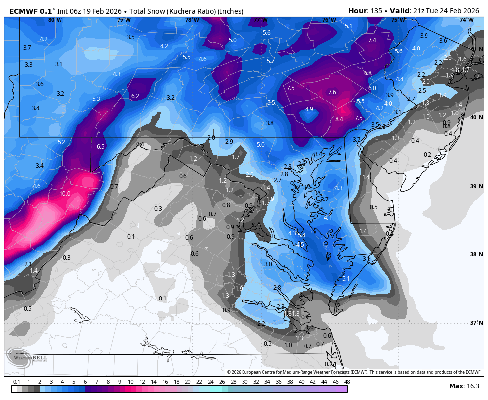
KEY MESSAGE 2... There remains a high amount of uncertainty with the development and track of a coastal low Sunday into Monday. However, there has been a clear trend to the NW the last 24-36h in the low track with ECAIFS, AIGFS, the GEFS, and to a lesser extent the GEPS. The operational GFS and GDPS (Canadian) the last 2 to 3 runs have a low track that has been close enough to see some snowfall across the region, but not a major event. Bottom line, there has been a lot of jumping around of the guidance and this is likely due to complex interaction between multiple streams/upper lows embedded within a longwave trough across the western half of the country. This could still be the case another 24h or so before we see better consistency amongst all of the guidance. Given the uncertainty, the forecast has continued to follow the NBM. NBM probabilities for 6 inches or more are generally less than 15 percent, highest across LI. Even advisory level snows get no higher than 20 percent. That being said, the guidance being all over the place has kept these numbers low. The system though is very much worth watching because of its potential with incredible deepening of the low Sunday afternoon and night. Pressure falls around 24 mb in 12h in the 00Z GFS and GDPS. The potential for high winds and heavy precipitation is a concern should a more western track become the consensus. &&
-

-
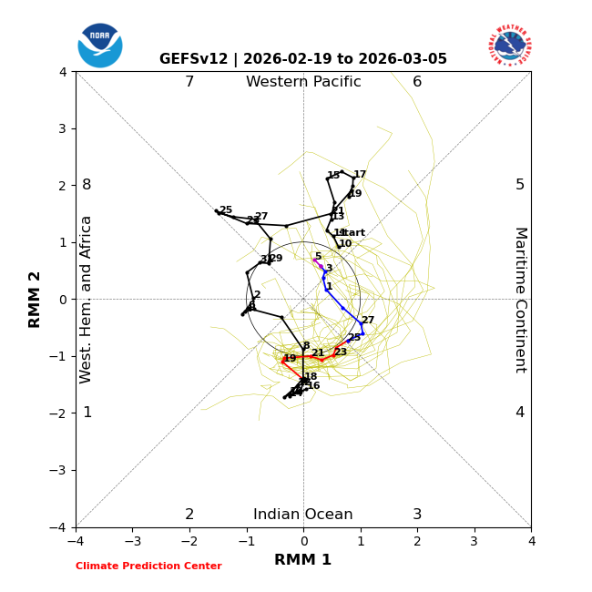
If the lag is 5 days the effects of phase 7 will be between the 11th and 15th.
-
I’d be very happy with all of that for pack reasons. Then flip back to snow for a few more into Saturday
-
Seems like kitchen sink here but hopefully the happy ending is 1-3 additional.
-

“Cory’s in NYC! Let’s HECS!” Feb. 22-24 Disco
Kitz Craver replied to TheSnowman's topic in New England
Wolfie would absolutely be losing his mind with us hedging the legacy EURO -
Was it elliptical day for him at the gym or did he get bicep curls in too?
-

Feb 22nd/23rd "There's no way..." Storm Thread
wasnow215 replied to Maestrobjwa's topic in Mid Atlantic
I heard Southwest Airlines flew into the system and took readings and samples and all. Now all the models feel free to roam about the country!! -
Still too slow to reach 7. If the lag is 5 days the effects would be felt between the 11th and 15th.
-
Looks like some snow to sleet and then freezing rain, but I don’t think a ton of precip is ZR there. You’ll likely glaze for sure but temps aren’t that cold. Maybe 31 there?
-

Feb 22nd/23rd "There's no way..." Storm Thread
IronTy replied to Maestrobjwa's topic in Mid Atlantic
It wasn't terrible. Well it might have been if you're a crybaby living west of the bay.
-
Crazy, that band just set up shop and barely moved for about 18 hours. Ended up with 6” imby