All Activity
- Past hour
-
board legend
-

July 2025 Obs/Disco ... possible historic month for heat
MegaMike replied to Typhoon Tip's topic in New England
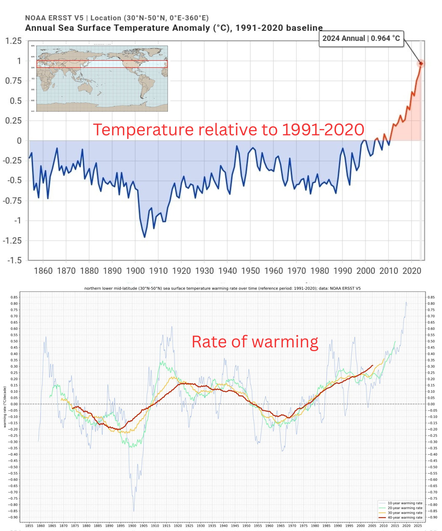
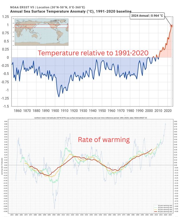
Logically, it doesn't make sense to me: Let's bring in data scientists to create a stand alone, meteorological modeling system lol. I'm sure it'll get better (build dat' training dataset), but for now, I'd say they're 1-2 decades away from making anything comparable to traditional NWP. I still think using AI to bias correct ic/bcs is the way to go. I know that has merit. Yea, it's a bit misleading... They used HRRR analysis as ground truth to make the conclusion that 'HRRR-Cast is comparable to HRRR...' I'd still rather see evaluations/comparisons at METAR/radiosonde sites. -
Yeah, the record breaking December 2015 +13° around our area seemed to be the very beginning of this shift. We still continued the epic snowfall and benchmark tracks that started in 09-10 until 17-18. Then the rapid jump in the mid-latitude ridging and SSTs began around 18-19. It shifted the winter storm track through the Great Lakes and gave us the record low snowfall for a 7 year period.
-

2025-2026 ENSO
40/70 Benchmark replied to 40/70 Benchmark's topic in Weather Forecasting and Discussion
Exactly right. -

July 2025 Obs/Disco ... possible historic month for heat
dryslot replied to Typhoon Tip's topic in New England
Its creeping up slowly. -

July 2025 Obs/Disco ... possible historic month for heat
SouthCoastMA replied to Typhoon Tip's topic in New England
Fair enough, I was being hyperbolic -
Today will be another below normal temperature day across the area before we start a warming trend to close out the work week. The hottest day will be Friday with widespread 90's across the area. We turn wetter and a little cooler over the weekend with rain chances - but not a washout for much of the weekend.
-

E PA/NJ/DE Summer 2025 Obs/Discussion
ChescoWx replied to Hurricane Agnes's topic in Philadelphia Region
Today will be another below normal temperature day across the area before we start a warming trend to close out the work week. The hottest day will be Friday with widespread 90's across the area. We turn wetter and a little cooler over the weekend with rain chances - but not a washout for much of the weekend.
-

July 2025 Obs/Disco ... possible historic month for heat
kdxken replied to Typhoon Tip's topic in New England
-
Bottom line, something very drastic changed in the global SSTA patterns, atmospheric long wave circulations/Hadley cells, QBO evolutions and arctic sea ice after the 15-16 super El Niño. Is solar/geomag playing some sort of role too? Maybe
-

July 2025 Obs/Disco ... possible historic month for heat
Sey-Mour Snow replied to Typhoon Tip's topic in New England
It's really like 2-3 months of fall, 2-3 months of summer, 1 month of winter and 5-7 months of early spring.. -
July 2025 Obs/Disco ... possible historic month for heat
kdxken replied to Typhoon Tip's topic in New England
72° / 59° still okay but I was spoiled by yesterday. You can feel the difference while you're working. -
Sorry for your family's loss, John
-
Sorry for your loss.
-
The past few days of radar versus actual rain and future forecasts tell me that Greenville County (below T.R.) is at the epicenter of the heat dome. Seriously, storm's dry up as they reach middle Greenville County. We have gotten only 1.25" of rain all month and nothing in the last week or so. On a bright note, we ate lunch yesterday at our favorite spot in Fletcher, Kosta's Kitchen. It was only 74 degrees with a wonderful breeze at 1:00, nice enough to sit outside on the porch area. I am ready for apple season and cooler weather.
-
Only managed a low of 65 down this way. I'm heading up PA Rt. 44 this weekend. I'll be very close to the Black Forest Inn if you know where that is.
-
Long term looks very dry
-
Taking this a step further, SPC has the eastern US "under the gun" for repeated rounds of severe weather extending well into next week.
-
July 2025 Obs/Disco ... possible historic month for heat
SouthCoastMA replied to Typhoon Tip's topic in New England
Hang on to the summer you have before we enter the 8 month autumn period -

July 2025 Discussion-OBS - seasonable summer variability
SACRUS replied to wdrag's topic in New York City Metro
Heat looks to come north again Mon - Tue next week. Id say the hottest areas have 4 or 5 of 7 days 90+ and 3 95+ 7/24 - 7/30, -
54 degrees this morning for the low.
-

July 2025 Discussion-OBS - seasonable summer variability
Brian5671 replied to wdrag's topic in New York City Metro
Not buying a washout yet-only the Euro really shows that right now -
July 2025 Discussion-OBS - seasonable summer variability
SACRUS replied to wdrag's topic in New York City Metro
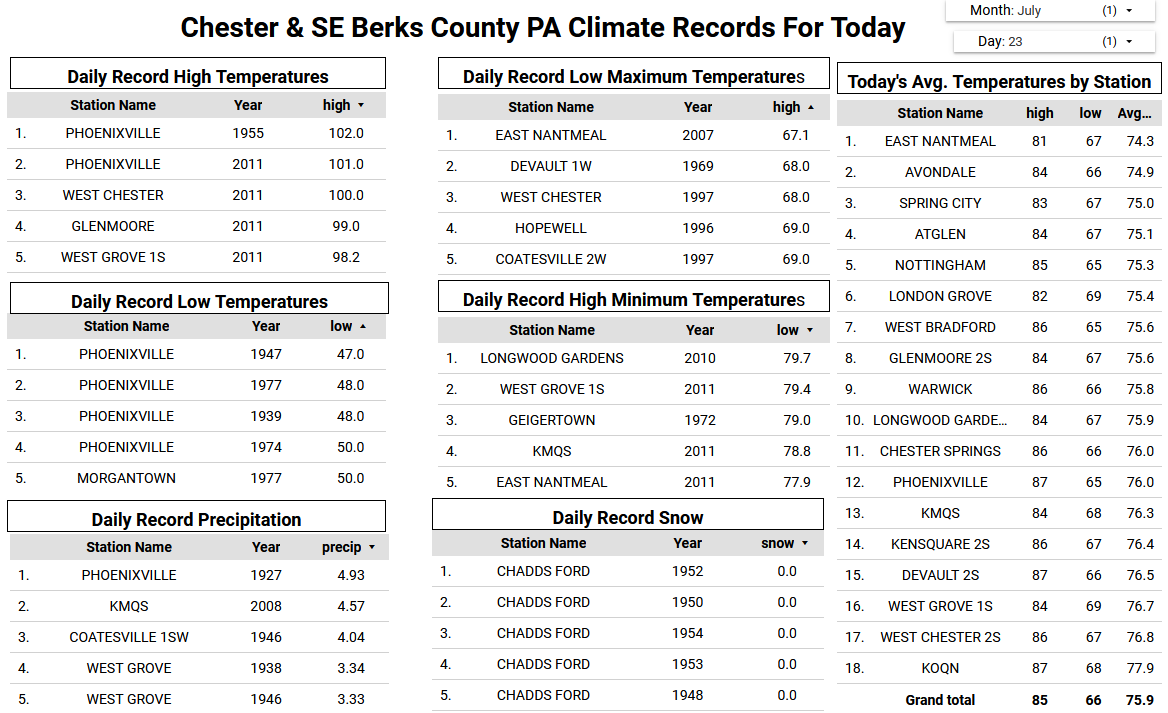
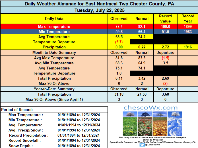
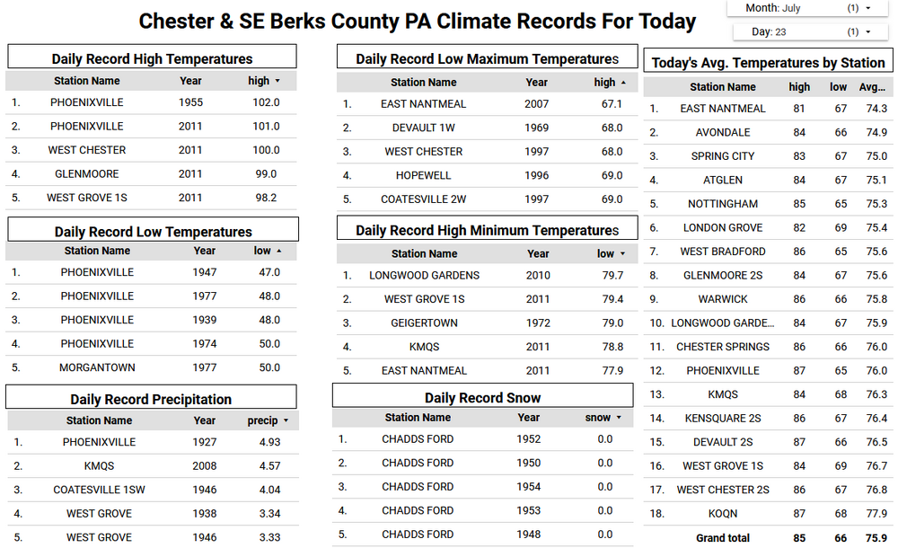
Records: Highs: EWR: 102 (2011) NYC: 100 (2011) LGA: 100 (1955) JFK: 102 (2011) New Brnswck: 105 (2011) Lows: EWR: 55 (1939) NYC: 58 (1890) LGA: 59 (1992) JFK: 59 (1992) New Brnswck: 51 (1931) Historical: 1788 - A weather diary kept by George Washington recorded that the center of a hurricane passed directly over his Mount Vernon home. The hurricane crossed eastern North Carolina and Virginia before moving into the Central Appalachians. Norfolk, VA, reported houses destroyed, trees uprooted, and crops leveled to the ground. (David Ludlum) 1788: Called the George Washington's Hurricane, this storm originated near Bermuda on the 19th before making landfall in Virginia. It passed directly over the Lower Chesapeake Bay and Mount Vernon, the home of George Washington. This track is very similar to the path of the Chesapeake-Potomac hurricane of 1933. At Norfolk, winds increased at 5 p.m. on the 23rd with the wind originating from the northeast. At 12:30 a.m., the wind suddenly shifted to the south and "blew a perfect hurricane, tearing down chimneys, fences"...some corn was also leveled. Also, large trees were uprooted, and houses were moved from their foundations. Port Royal and Hobb's Hole experienced a violent northeast gale which drove several vessels ashore. In Fredricksburg, vast quantities of corn, tobacco, and fruit were destroyed. Houses and trees fell in significant numbers across Northumberland, Lancaster, Richmond, and Westmoreland counties. Crops were destroyed, and many livestock perished in Lower Mathews County. Many plantations saw their houses leveled. Homes were flooded with water six feet deep, and several inhabitants drowned. Historical figures of the time logged the storm's antics. George Washington noted the sinking of the small ship Federalist and uprooted trees. Colonel James Madison, the father of the future president, experienced the passing of great winds and rains near Orange. In Alexandria, damage to wheat, tobacco, and corn was "beyond description." The information above is from the Weather Prediction Center and noted American historian David Ludlum. 1898 - A two hour thunderstorm deluged Atlanta, GA, with 4.32 inches of rain. More than a foot of water flooded Union Depot. Many street car motors burned out while trying to run through flooded streets. It grew so dark before the afternoon storm that gas lights were needed. (The Weather Channel) 1923 - Sheridan, WY, was drenched with 4.41 inches of rain, an all-time 24 hour record for that location. Associated flooding washed out 20 miles of railroad track. (22nd-23rd) (The Weather Channel) 1975: Severe thunderstorms affected parts of northern and central Illinois. In Peoria, winds gusting to 85 mph knocked over trees. Two tornadoes affected Fulton County. The first passed through mainly rural areas. The second tornado caused major damage in Canton, where 127 businesses and 100 homes were destroyed. 300 other homes and 100 trailers were damaged; total damages were around $20 million dollars. Two people were killed as the tornado moved through a mobile home park. Power lines were downed during the storm; some areas were without power until the 28th. (Ref. Wilson Wx. History) 1979: Intense thunderstorms dumped copious amounts of rainfall over the western parts of Oklahoma. Rainfall amounts were quite impressive, including reports of up to 7 inches just north of Arapaho, in Custer County. Four inches of rain fell in just one hour east of Arapaho and two inches of rain fell in only 30 minutes in Clinton. Many creeks and rivers were quickly forced out of their banks by the heavy rainfall. Floods covered the Arapaho-Weatherford Road with as much as 4 feet of water. More than 5 inches of rain fell in the Taloga area of Dewey County, causing Highway 183 to be inundated by one to two feet of flood water. (Ref. Wilson Wx. History) 1985: Tropical Storm Bob moved across south Florida from Ft. Myers to just north of Palm Beach. The storm then turned north and moved northeast of Florida. The storm did minor damage to roofs and downed some trees, mainly on Florida's west coast. Rainfall amounts ranged up to 13 inches at Naples. Several beaches suffered erosion from Port Charlotte to Marco Island. (Ref. Wilson Wx. History) 1987 - Thunderstorms produced a record ten inches of rain in six and a half hours at Minneapolis, MN, including 5.26 inches in two hours. Flash flooding claimed two lives and caused 21.3 million dollars damage. Streets in Minneapolis became rushing rivers, parking lots became lakes, and storm sewers spouted like geysers. A tornado hit Maple Grove, MN, causing five million dollars damage. Baseball size hail was reported at Olivia, MN. (The National Weather Summary) (Storm Data) 1988 - Thunderstorms produced severe weather in Lower Michigan and northern Ohio, over eastern sections of the Dakotas, and over the Central High Plains Region. Showers and thunderstorms soaked Wilmington, NC, with another two inches of rain, following six and a half inches the previous day. (The National Weather Summary) 1989 - Morning thunderstorms in the central U.S. drenched central Oklahoma with up to six inches of rain. Afternoon thunderstorms produced wind gusts to 85 mph at Fort Smith, AR. Evening thunderstorms over Florida spawned a tornado which touched down three times in south Fort Myers causing nearly three quarters of a million dollars damage. (The National Weather Summary) (Storm Data) 1995: At Dodge City, KS thunderstorm winds to 100 mph caused extensive damage to fences. One filling station canopy was downed and it landed on two occupied vehicles but there were no injuries. One roof was taken off a house with debris scattered several hundred yards. A large storage shed was heavily damaged with two motor homes inside receiving extensive damage. Debris was carried one quarter of a mile. (Ref. Wilson Wx. History) 1998: Thunderstorms produced a record ten inches of rain in six and a half hours at Minneapolis, MN, including 5.26 inches in two hours. Flash flooding claimed two lives and caused 21.3 million dollars damage. Streets in Minneapolis became rushing rivers, parking lots became lakes, and storm sewers spouted like geysers. A tornado hit Maple Grove, MN causing five million dollars damage. Baseball size hail was reported at Olivia, MN. (The National Weather Summary) (Storm Data) 2003: Boise, Idaho: With a reading of 107°F, a new record was set for the number of consecutive days with temperatures above 100°F. July 23 marks the 9th consecutive day. (Ref. WxDoctor) (Ref. Additional Temperatures Listed On This Link) 2006: This was the peak of an intense July heat wave that affected much of California and the NW United States thanks to an intense upper level heat ridge. Fresno, CA was the hottest since 7/27/1933. An all-time record high minimum was set with 90°. In Lemoore, 10,000 customers lost power for up to four hours. In all, 46 deaths were reported with 18 injuries. Eugene, OR tied their July record with 105°. Other daily record highs included: Phoenix, AZ: 114°, Redding, CA: 114°, Sacramento, CA: 111°, Lewiston, ID: 109°, Medford, OR: 107°, Spokane, WA: 102 °F. (Ref. Wilson Wx. History) 2008: Rhode Island: A waterspout forms at about 4 pm just off Rumstick Point near Barrington then moves onto land as a tornado in Warren before moving into the Ocean Grove section of Swansea, Massachusetts. The tornado's path is estimated as 4.2 miles long and 40 yards wide. No injuries are reported, but damage to trees, power lines and houses is reported.(Ref. WxDoctor) 2010: After a severe thunderstorm, a Vivian South Dakota resident, Les Scott, found a hailstone with a diameter of 8.0 inches and its weight was 1.9375 pounds (1 pound, 15 ounces) with a circumference of 18.62 inches. These measurements displace the previous hailstone record for weight, previously 1.67 pounds for a stone in Coffeyville, Kan., in 1970. They also surpass the record for the greatest diameter, which was 7 inches for a hailstone found in Aurora, Neb., in 2003. But the Aurora hailstone still holds the record for the greatest circumference of 18.75 inches. (Thus the Aurora hailstone was more spherical than the Vivian hailstone.)(Ref. NOAA News Release July 30, 2010 - Record Hailstone )(Ref. See a Picture of the World's Largest Hailstone)(Ref. Info. on the Storm Yielding Hailstone(Ref. See a video About the World's Largest Hailstone) 2011: Chicago set an all-time daily record rainfall when 6.86 inches fell during the early morning hours of Saturday, July 23, 2011, at O'Hare airport. The previous daily record was 6.64 inches set on September 13, 2008. -
RIP jburns
-

July 2025 Discussion-OBS - seasonable summer variability
LibertyBell replied to wdrag's topic in New York City Metro
Yes but unfortunately rainy Sunday.