All Activity
- Past hour
-
 best indian pharmacy website [url=https://indigetrx.shop/#]indian pharmacy shipping to usa[/url] pharmacy website
 -
That would be a shocker but you never know around these parts. The next 2 weeks are a welcome drying out if El Nino really kicks up the STJ. Average first frost used to be between October 1-15 r here until about 2000. Since then its closer to October 24.
-
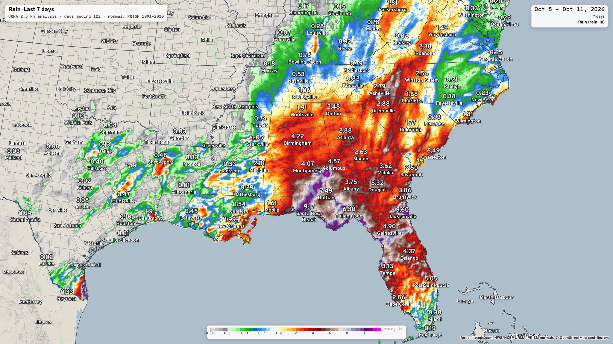
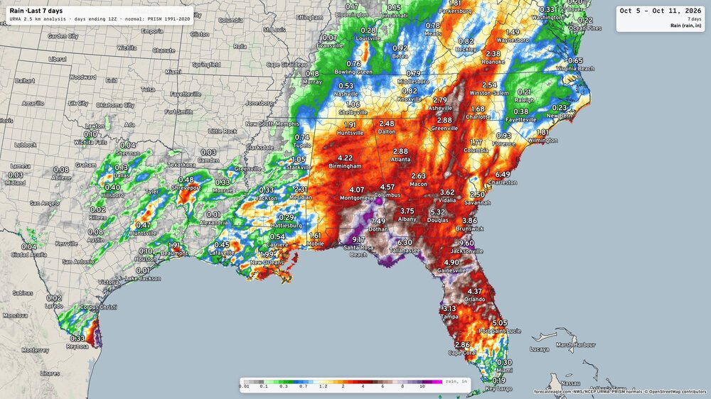
Raleigh was squarely in the screw zone this time around
-
what a day. 73 no wind tolerable RH and at least some feeble warmth value still to the sun. top 10er actually -
-
After the cool down later this week warmth returns over a rather large area of North America.
-
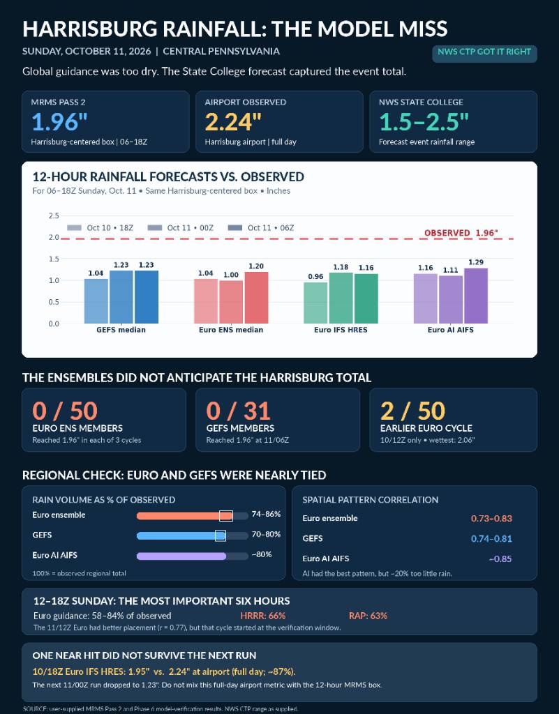
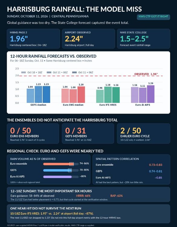
shall we discuss the total and complete collapse of every single model and ensemble model for this past system. The HRRR literally had a negative skill score at 3 hours that's how bad it was. and it wasn't just the American the euro is just as bad I don't know what that hints for this winter time but that was the most epic and total failure I have seen by models in a long long time Sent from my SM-S731U using Tapatalk
-
90 in the paign, with a chance again tomorrow. Unbelievable for October 12th.
-

2026-2027 Record-breaking El Nino
bncho replied to Stormchaserchuck1's topic in Weather Forecasting and Discussion
we talk about snow autism in here but the guy looks like he has real autism if u look at his other videos -
At the time there was no hurricane. Had that not developed it would have been Stein
-
E PA/NJ/DE Autumn 2026 Obs/Discussion
KamuSnow replied to PhiEaglesfan712's topic in Philadelphia Region
We call days like yesterday "rainout theater", lol. - Today
-
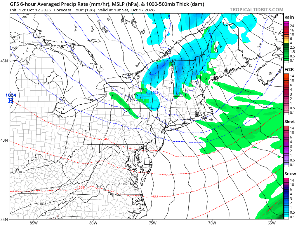
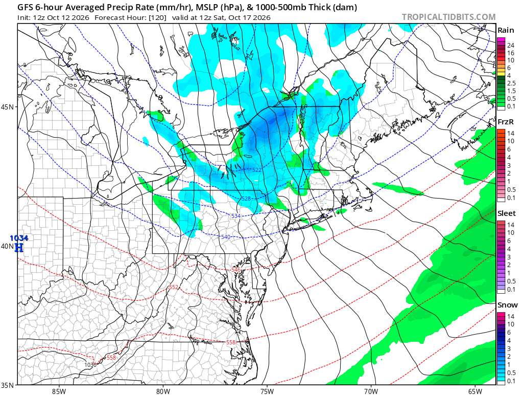
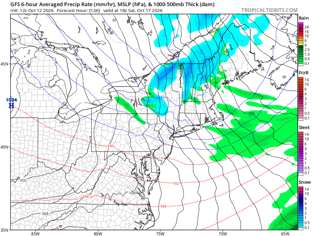
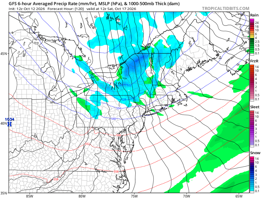
Ah yes, even better haha. Euro has snow through much of NNE Saturday with daytime highs in the 30s up my way.
-
http://cangetrx.com/# canadian pharmacy 365
-
legitimate canadian online pharmacy: CanGet Rx - pharmacies in canada that ship to the us
-
Alright, enough time has passed to throw this solution out the window. So what's figure out what went wrong as an exercise for this winter. So, our setup relied on a branch of the NS detaching and creating an unusually deep trough over the east coast in order to bring both cold air and the correct wind flow (NNW) to catch moisture from the lakes. Now, what initially would cause this NS trough? Turns out it was an interaction with a SW wave helping to pull it down (GFS run from when it was snowy) Compare that to it's current run. Though we still have our two main players it's interesting how different the circumstance is. Firstly, the interaction is occurring further east, which obviously hurts us. However, what is most interesting is that blob of vorticity over central Mexico as its a Hurricane ejecting it's energy eastward and thus pulling the pattern to be progressive. On the old runs the GFS brought it out to sea instead. Look at the knock on effects it has! On the old run you have a near textbook PNA ridge Now, you can see how there is more energy getting held underneath the ridge (the Hurricane's remains are now in there) which causes a flatter, and thus less blocky, ridge. Some other things you can notice is the previously detached low upstream of our trough has now morphed with it, which reduces the blocking pattern, and that the Artic in general is less amplified than before. All in all, pretty much everything went the wrong way for the mountains to pick up a significant snowstorm. Now, the reason I did this is 1. I'm bored and just took a climatology exam 2. To warmup for winter 3. To see how the models did. As mentioned in my first post nearly all models but the operational Euro had a pattern conducive to accumulating snow, and the reason the Euro didn't is because even back over the weekend it was correctly modeling the tropical impact over Mexico. This should be a lesson against trusting the AI models, as even they were wrong. Furthermore, the hurricane change was within 5 days from this weekend, and it was a dramatic miss, which should call into question any forecast beyond day 4 for synoptics (assuming our current funding for NOAA's soundings and data collection stays the same). Frankly, I wonder if our bad miss on the ice/snow line for last January's storm would've happened if we weren't cutting their data intake as it was a huge miss by our modeling for the storm track and impacts even at day 3. The bottom line of this post is we need to be extremely cautious in trusting the models come this winter. They simply are not preforming as well as in years past when it comes to what matters for us. I personally would not even trust the general synoptic pattern outside of day 3. Mets, or anyone else, please let me know how I did or if my reasoning was solid!
-
That is a very robust shortwave digging into the region with some healthy moisture in place and rather steep lapse rates. Wasn't looking at LES in this case...just more elevated/terrain enhancement.
-
We hope. It's not in fantasy land so I feel good about that. We can produce on these setups.
-
Hot and dry winter.
-

2026-2027 Record-breaking El Nino
GaWx replied to Stormchaserchuck1's topic in Weather Forecasting and Discussion
I agree about 30 mb being off in amplitude but the patterns as you’ll see below are very similar. Thus, that allows me to still predict with a very high level of confidence that a solid +QBO is in store for all of this winter. Here are the tabular 30 mb QBO values since Jan ‘25 for the table that stopped updating (PSL): 2025 12.11 10.55 11.82 6.94 -4.59 -13.72 -19.99 -22.28 -24.26 -24.65 -25.35 -26.92 2026 -25.51 -23.13 To compare, here are the tabular 30 mb values from the QBO link that @EasternLIposted this morning for the still updating site (ATMO) (bolded are the ones we can’t compare to old table, 3/26+) 2025 10.3 7.3 8.4 4.7 -16.5 -25.4 -27.8 -29.2 -30.5 -30.8 -30.0 -29.7. 2026 -29.2 -31.2 -30.9 -7.0 5.7 7.5 13.3 11.5 17.6 ATMO graph closeup for 2023+: jibes 100% with their textual values (actually the entire graph back to 1953 jibes): My observations in comparing the 30 mb tables of ATMO to PSL since 1953: -ATMO sometimes is slightly faster than PSL in switching phases, but the average is only a half month faster in switching from positive to negative (minimal). So, phase switching times are very similar. -ATMO almost always lower than PSL when negative: I counted 20 cycles out of 32 with ATMO negative dips <-30 vs none for PSL -ATMO least negative dip -25.0 in 8/1954 when PSL dipped only down to -14.53, also their least negative dip since 1953 -Lowest ATMO: -35.5 in 9/1996 (when PSL was -26.02) -Lowest PSL: -29.55 in 11/2005 (when ATMO was -33.3) -ATMO higher peak than PSL 29 cycles out of 33: I count 17 cycles out of 33 with ATMO peaks of 16+ vs none for PSL -Highest ATMO: +22.0 in 1/1953 (when PSL was -2.94) -Highest PSL: 15.62 in 6/1995 (when ATMO was 15.1) -So, ATMO cycles have higher amplitude than PSL though very similarly timed -# of months in positive periods in ATMO lasting 10+ months: 32 of 33. Longest on record is 18 months. ——————— The last stat tells me with near 100% confidence that all of winter ‘26-7 will be positive on ATMO. Why? The first positive month in the current phase was May of ‘26. The 10th month would be Feb of ‘27. Also, 22 of 33 positive phases lasted 12+ months with the avg length of a positive phase on ATMO being 13 months. Thus, my best guess as to the final month in the current positive phase per ATMO is within one month of May of ‘27. More than likely Feb of ‘27 will on ATMO still be >+10. The latest I can see the last positive month is Oct of ‘27 based on the 18 month record.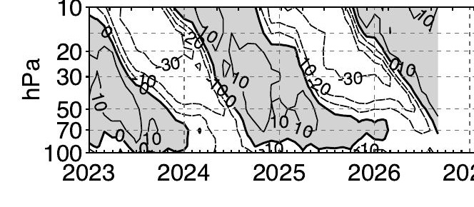
-
This would do it.
-
Was saying that in the NNE thread earlier haha. I've been skeptical, but there's a solid cross guidance signal for flakes up here this weekend. GFS was pretty aggressive along with its AI counterpart. Euro not as much. I like seeing the lingering moisture after the front. We can produce nicely on that. Not sure about the Tug however, as this looks like more NW flow than westerly off Ontario, if you're talking LES potential.
-

2026-2027 Record-breaking El Nino
LakePaste25 replied to Stormchaserchuck1's topic in Weather Forecasting and Discussion
-

Mid-Long Range Discussion 2026
WinstonSalemArlington replied to BooneWX's topic in Southeastern States
-
0.06" overnight. October has had measurable rain on 5 of the 12 days, for a grand total of 0.14". GYX thinking about an inch by Wednesday noon. Hope that verifies.
-
Definitely counted wrong yesterday morning, but ended up around half an inch maybe just under. Nice to see some sun though!
-
Despite my yard, there are some nice colors popping around the area.