All Activity
- Past hour
-
Dry because it hasn't gotten near the coast.
-

January 2026 regional war/obs/disco thread
Damage In Tolland replied to Baroclinic Zone's topic in New England
Who cares. The snower will s Thursday/ Friday -
Just looks like a reply of the Thursday storm. Cut off that comes from the north. Surface is pretty dry.
-
Yeah 18z looked good again for us. The adjustments are not done though but hopefully we see more continuity.
-
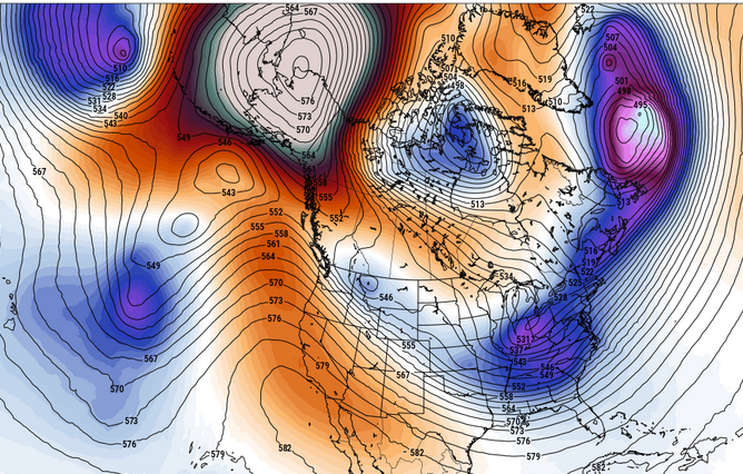
wow ... just going over all this stuff today... there is sooo much potential in all this I don't even know where to begin. my god The GEFs 18s first off all ..it's actually attempting to parse the 2nd wave/reduce it's interference, such that both events get a shot. There's an emerging -EPO that could be truly historic. 580 dm heights closed over the Alaskan sector is ...well. whatever. This is pretty exotic in the operational run. I mean it's in the long range so it's just eye candy but that's a what-the-fucker up there
-
I was told 5H didn't matter
-
Again, these are the Spiking pna without a 50/50 low…hmmm.
-
Yeah the GFS was showing the moisture from this morning coming in for a few days but was playing catchup as well. The Euro didn't have it until yesterdays 12z run. The euro has been too dry as well. But the euro at least at the H5 pattern basically nailed this cold front from 10 days out except the surface temps surprise surprise we about 20 to 30 degrees TOO WARM. honestly I only look at the gfs at short range anymore but all models have been struggling.
-
umm, I know TSSN+ posted the Ukie stunk for storm 1, but I don't think anyone posted anything on the Ukie's take on the Cape storm, did they?
(6).thumb.png.ad155653c8e848aac92e1bee798233a0.png)
.thumb.png.c8b06c209560103f6f4d5632f2909ba0.png)
-
Okay euro is running. Good luck to us
-
I agree to an extent but I would like to see the trough somewhat west. I personally would feel better about it
-
Go on
-

January 2026 regional war/obs/disco thread
Snowcrazed71 replied to Baroclinic Zone's topic in New England
For now...... -
And now Nick and AJ are chirping at each other on the sideline. It’s a Philly thing.
-
Snow is snow
-
I totally agree. I see you out there fighting the fight. My joke fell flat. It's an uphill battle, man, those are indeed the "loudest", as you say, and always draw the most attn. I haven't given up on this winter no f-in way.
-
lol snow map isnt much different than 12z, when everyone was chipper.
-

January 2026 OBS and Discussion
coastalplainsnowman replied to TriPol's topic in New York City Metro
Do you pity the fool who believes anything over two days out? -
Their persistence skews the overall sentiment.
-
2” would make me quite happy.
-
I can really only think of 1 with that mentality lol
-
Late week storm still on the table per the 18z GEFS. I think we know its probably a light event if it happens.
-
I don't trust the MJO plots right now. I quit using them about three weeks ago(roughly). I do think there are about to be some good things happen in the phase 8 region though, and that might be a legit signal - I hope. February in phase 8-1-2 would be crazy good. So far(fingers crossed) Feb looks like it is going to be a winter month this year....the Nina should begin to retreat to weaker levels by then. A weak Nina in February w/ a negative QBO is usually a great combo. I think what is driving the bus right now is the EPO (NAO component possible), and until it relents...going to assume blocking trumps the rest.
-
Wow, that is the first run I've seen that has pretty much lost that annoying positive-tilt sw to be orientation of the PNA ridge...can work with that if it's real. Previously that wasn't rectified until the follow up wave.
-
there should be a thread where only meteorologists and pro forecasters can post, view only for everybody else


(6).png.043d19aa88a2f58e084e4ab5f970d40f.png)
.png.935b48dd7e4540ddc80a123af001562d.png)


