All Activity
- Past hour
-
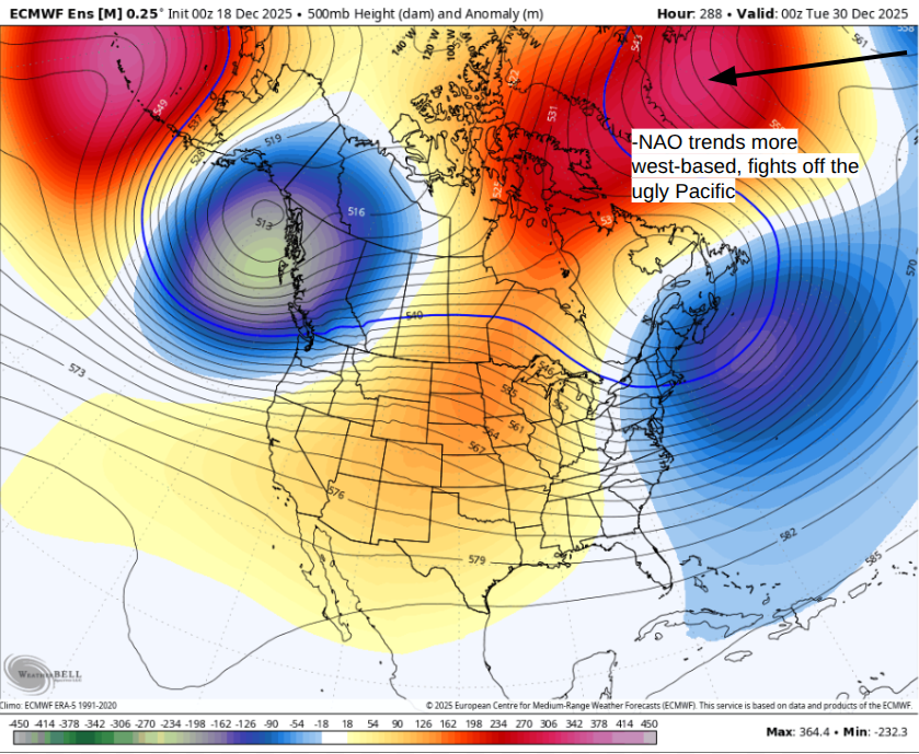
Liking the trends I saw. As that super -NAO starts to trend more west-based it kinda moves the central-US ridge west because the -NAO amplifies the eastern trough, which inherently helps us trend towards a more positive PNA (trending from negative towards neutrality). A 6z GFS kind of scenario is certainly possible--that storm actually tries to cut N/NW-ward--but the -NAO is just so strong that it gets shunted south giving US some wintry weather.
-
It really just sounds like an argument over if the glass is half full or half empty. I choose to appreciate the flakes we got even though it's frustrating to have been so close to more significant accumulation
-

December 2025 regional war/obs/disco thread
weatherwiz replied to Torch Tiger's topic in New England
Well at least a coating did fall...and then another couple inches on top of it -

December 2025 regional war/obs/disco thread
Damage In Tolland replied to Torch Tiger's topic in New England
You must be referring to your flurries up to a coating call for SNE on Sunday -

December 2025 regional war/obs/disco thread
The 4 Seasons replied to Torch Tiger's topic in New England
that makes sense, and thats why mobile sucks, watered down experience...but it's necessary sometimes. we've had this conversation before about 3 or 4 years ago pc vs. phone users -
@nrgjeffif you are gonna give us some wx goods today, we must talk basketball. After a three game skid, the Vols finally showed some promise with that win over Louisville(though admittedly missing a key guard for that game).
-
December 2025 regional war/obs/disco thread
weatherwiz replied to Torch Tiger's topic in New England
Explains why your forecasts have gone downhill -
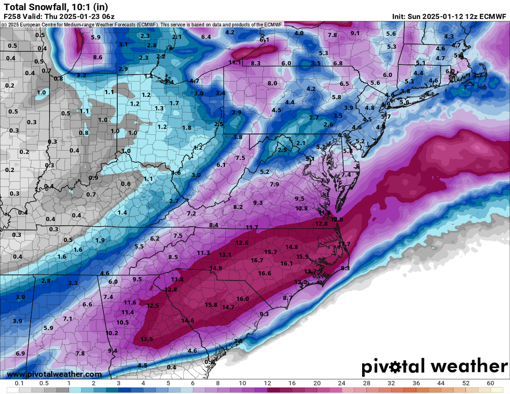
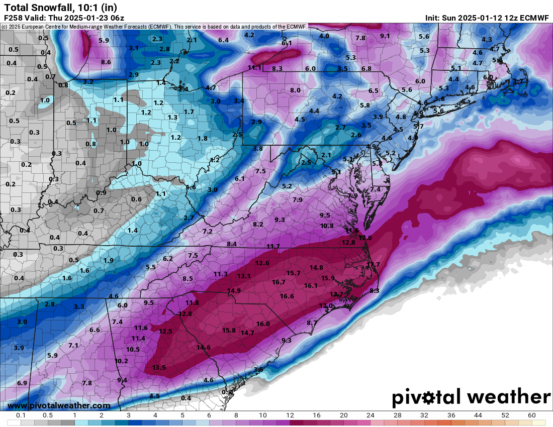
This Euro storm reminds me of another at 9-10 days out released on 1/12/25 that caused social media to get way out of control and even caused me to be texted in the middle of the night from an Atlanta friend due to his Facebook feed from this as if it were credible: But this did turn out to be when the historic Gulf coast/deep SE winter storm occurred (1/21-22/2025).
-
I guess we will have to wait and see if this actually develops. The way I tend to look at this is that models even today cannot see pattern changes coming until they are within the medium range. It's fun to look at the weeklies, but there really is very little skill past 10-15 days. So maybe we do get a +PNA flip, maybe we don't, but I am confident that models don't know either
-

E PA/NJ/DE Winter 2025-26 Obs/Discussion
Ralph Wiggum replied to LVblizzard's topic in Philadelphia Region
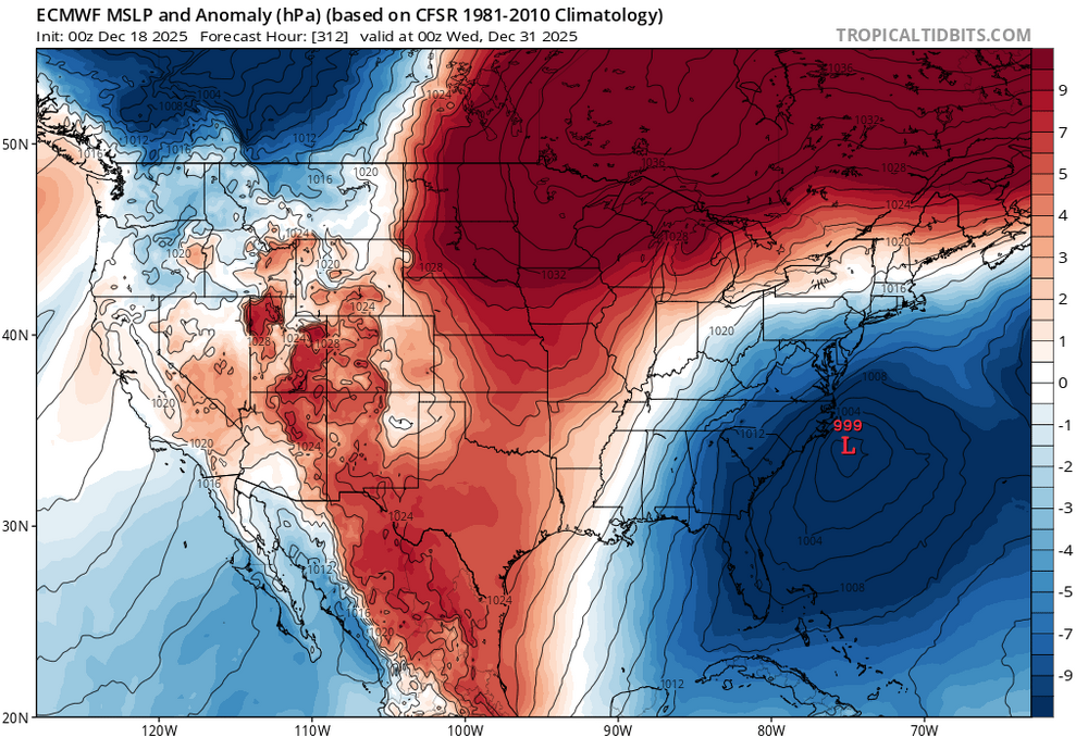
Models have been hinting pretty good wrt to tue Dec 28-Jan 2 period for almost a week already, albeit off and on. But now we're are seeing a growing signal across the ens means as well as an NAO blocking signature emerges from Scandinavia. Hunches dont get us winter storms, but instinct is suggesting this is a legit trackable window. -
Nice fake cold last night. Min was pretty steady around 26⁰ for several hours, then rising slightly to 28 by 8:30, then to 46⁰ by 9:30 (up 17 degrees in an hour). If it hasn't scoured out by you yet, wait a few minutes.
-
Last night's Euro had a very similar scenario, but a few days later and kept the bulk of the system to our south. Close enough, however, to qualify as a match in my weenie manual! Lol
-

December 2025 regional war/obs/disco thread
Typhoon Tip replied to Torch Tiger's topic in New England
heh...not sure how to use that 'multiquote' but ha, nice to see the agreement among Mets there -
December 2025 regional war/obs/disco thread
Damage In Tolland replied to Torch Tiger's topic in New England
I’m only ever on here on phone . I don’t see any sigs. People actually still log on here on computers? It’s probably been 2019 since I last used a PC for here -
December 2025 regional war/obs/disco thread
Typhoon Tip replied to Torch Tiger's topic in New England
-
December 2025 regional war/obs/disco thread
Typhoon Tip replied to Torch Tiger's topic in New England
-
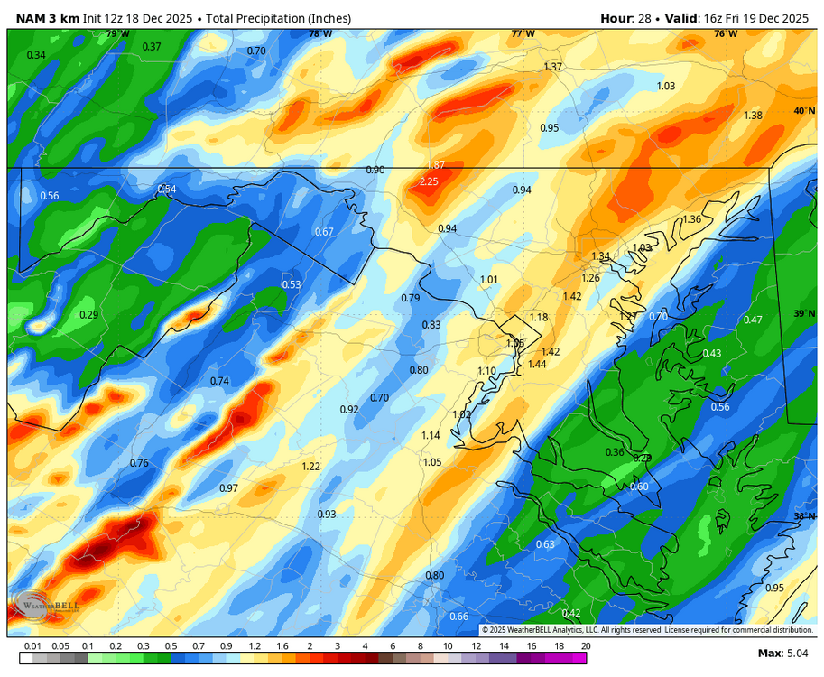
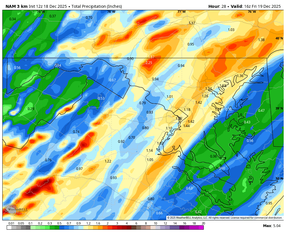
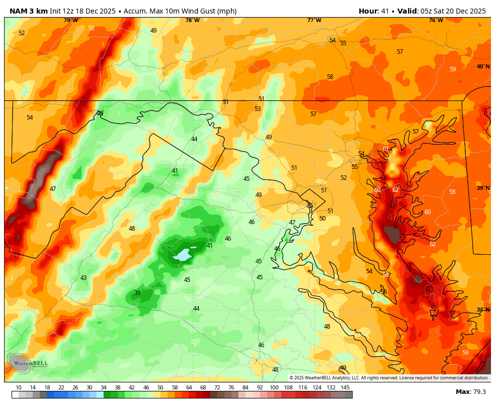
WB 12Z 3K NAM....rain and wind incoming...

-
December 2025 regional war/obs/disco thread
The 4 Seasons replied to Torch Tiger's topic in New England
since youre off, maybe its time to update that sig, winter 18-19 is a little out of date -
Negative NAO doing its work
-

2025-2026 ENSO
donsutherland1 replied to 40/70 Benchmark's topic in Weather Forecasting and Discussion
For reference, the December and January snowfalls for New York City (1980-Present) with the teleconnections you listed: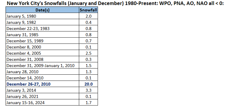
-
I never said otherwise; in fact, when replying to a member who said, "I guess snow falling from the sky without accumulating is considered measurable nowadays," I replied with, "Measurable snow is considered .1" or more." The comment I was addressing was "not even a single trace, much less multiple instances" had occurred in the Hickory/Catawba County area. I replied to that comment saying that there had been multiple reports on social media of snow falling on different dates, which confirms that at least a trace of snow had fallen on more than one occasion so far this winter. I think most would agree that seeing snow falling on three or four separate occasions at any given location in NC outside of the mountains before mid-December, even if it melts on contact, is impressive.
-
December 2025 regional war/obs/disco thread
Damage In Tolland replied to Torch Tiger's topic in New England
Never too early .. especially when on PTO -
https://arstechnica.com/science/2025/12/trump-admin-threatens-to-break-up-major-climate-research-center/ Ik people stay away from politics here, but this would be awful if it happened. even if nothing happens (it probably won't), I hate that our field is politicized needlessly, and this really undermines the stability of the work they do at ncar
-
It happened a lot last year too iirc. It wasn't a high snowfall winter but last winter was certainly more old school flavor than the last 15+ years. 2013-15 was an extreme/unusual pattern. Last year was different in that respect. Intuition has been prodding me last couple years that the decadal or whatever it is blocking cycle was flipping and this year is basically confirming it (for now at least). Doesn't mean every winter will be blocky but it does imply that 8 out of 10 or 10 out of 13 will be blocking friendly based on history. We can worry about that later after the NAO does some magic this year haha
-
Nope and thats where we blew the forecast pretty hard. i had 1-2/2-4 in areas that picked up over 6. Everywhere else the forecast did pretty well though


.thumb.jpg.ad3a2e31d30aff035044689b311a0540.jpg)
