All Activity
- Past hour
-
i hope i see a big one https://www.wcvb.com/article/boston-rodent-action-plan/65670745
-

Hurricane Erin - 145 mph - 935mb - WNW @ 20
Windspeed replied to BarryStantonGBP's topic in Tropical Headquarters
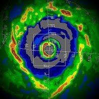
Erin's eyewall is now quite intense, noted by the persistent ring of CGs tracing it. It may be a while before outer banding consolidates enough to form an outer eyewall band, so continued deepening may continue throughout Saturday. As such, I don't think we have seen Erin level out. Another 15 to 20 mb drop in pressure is quite possible this afternoon. I expect Erin to reach Category 5 intensity by this evening prior to any leveling off and its first eyewall replacement cycle to start doing its thing. -

Hurricane Erin - 145 mph - 935mb - WNW @ 20
BarryStantonGBP replied to BarryStantonGBP's topic in Tropical Headquarters
OI OI OI ERIN ERIN ERIN SCORE SAM CAT 5 GOALS -
Yesterday was our warmest day so far this month with a couple spots even reaching 90 degrees for the first time in August. Today may be a couple degrees cooler before again reaching well into the 80's on Sunday. We then see a front swing through on Sunday night and behind this we turn much cooler for the rest of the week with high temperatures remaining in the 70's by day and upper 50's to lower 60's by night. Slight chances of showers most days of the week with the greatest chances by Tuesday night into Wednesday.
-
Wasn’t it still 100 at 5 AM? Holy shit
-
Skynet differs.
-

E PA/NJ/DE Summer 2025 Obs/Discussion
ChescoWx replied to Hurricane Agnes's topic in Philadelphia Region
Yesterday was our warmest day so far this month with a couple spots even reaching 90 degrees for the first time in August. Today may be a couple degrees cooler before again reaching well into the 80's on Sunday. We then see a front swing through on Sunday night and behind this we turn much cooler for the rest of the week with high temperatures remaining in the 70's by day and upper 50's to lower 60's by night. Slight chances of showers most days of the week with the greatest chances by Tuesday night into Wednesday. -
Due north.. right your fanny?
-

Hurricane Erin - 145 mph - 935mb - WNW @ 20
Kevin Reilly replied to BarryStantonGBP's topic in Tropical Headquarters
It is close, but I would say yes. At the very least it's on the FAR southern part of the cone pretty much moving west. Erin will do what she wants right now for the time being until the weakness in the ridge opens up. If anyone else wants to chime in great I am just comparing the NWS cone to the current satellite loops including water vapor maps. -
Working lol I think models shift around a bit later on.. already 30 miles south of the forecast track and still heading west
-
Next week looks like it will be the nicest week of summer 2025!
-
1234snow started following Hurricane Erin - 145 mph - 935mb - WNW @ 20
-
Yeah biggun
-
Hurricane Erin - 145 mph - 935mb - WNW @ 20
Eskimo Joe replied to BarryStantonGBP's topic in Tropical Headquarters
Uh, is Erin now outside the cone? -
Man MoreGarbage is cringe worthy.
-
Looks like we warm right back up last week of the month.
-
Got down to 56° in Falmouth. Chilly with the fans going. Water restrictions are already in place here.
-

Hurricane Erin - 145 mph - 935mb - WNW @ 20
WxWatcher007 replied to BarryStantonGBP's topic in Tropical Headquarters
931.9mb extrapolated on the latest pass with a 143kt FL wind. -
>Probably looking high temps upper 70s to low 80s with reasonable dewpoints if this verifies. It had better. To hell with this humidity. To hell with every damn summer being longer and muggier than the last. I want things to go back to normal, and by normal I mean the mild summers of the early sixties.
-

Hurricane Erin - 145 mph - 935mb - WNW @ 20
NorthHillsWx replied to BarryStantonGBP's topic in Tropical Headquarters
Pretty good example of the potential in the SW Atlantic this season. -
drstuess started following Tracking the tropics - 2025
-
Pretty impressive. Looks like 155 mph from recon. Still seems to be intensifying quickly. Some big pressure drops between passes. Sent from my SM-S901U using Tapatalk
-
Hurricane Erin - 145 mph - 935mb - WNW @ 20
Eskimo Joe replied to BarryStantonGBP's topic in Tropical Headquarters
Wow good morning Erin. -

Hurricane Erin - 145 mph - 935mb - WNW @ 20
hawkeye_wx replied to BarryStantonGBP's topic in Tropical Headquarters
6 mb drop in the last 50 minutes. -

Central PA Summer 2025
Mount Joy Snowman replied to Voyager's topic in Upstate New York/Pennsylvania
Low of only 73. Looks like some relief is on the way for the start of the work week. - Today
-
Hurricane Erin - 145 mph - 935mb - WNW @ 20
weatherCCB replied to BarryStantonGBP's topic in Tropical Headquarters
145mph 135mb


.thumb.png.4150b06c63a21f61052e47a612bf1818.png)
