All Activity
- Past hour
-
Wait until you walk her down the aisle. About the hardest day in the life of a girl dad. Happy but sad. And so final.
-
You don't need to worry about them. They'll be okay, and if they're driving distance or on an Amtrak line (Go Hoos!) then you can always be there if they need it. Besides, I've been told most people love college! I myself thought it wasn't quite worth the hype, but even then I'm doing well, and I'm not anything special so your kids will be fine too.
-

Central PA Summer 2026 Discussion/Obs Thread
TheDreamTraveler replied to Voyager's topic in Upstate New York/Pennsylvania
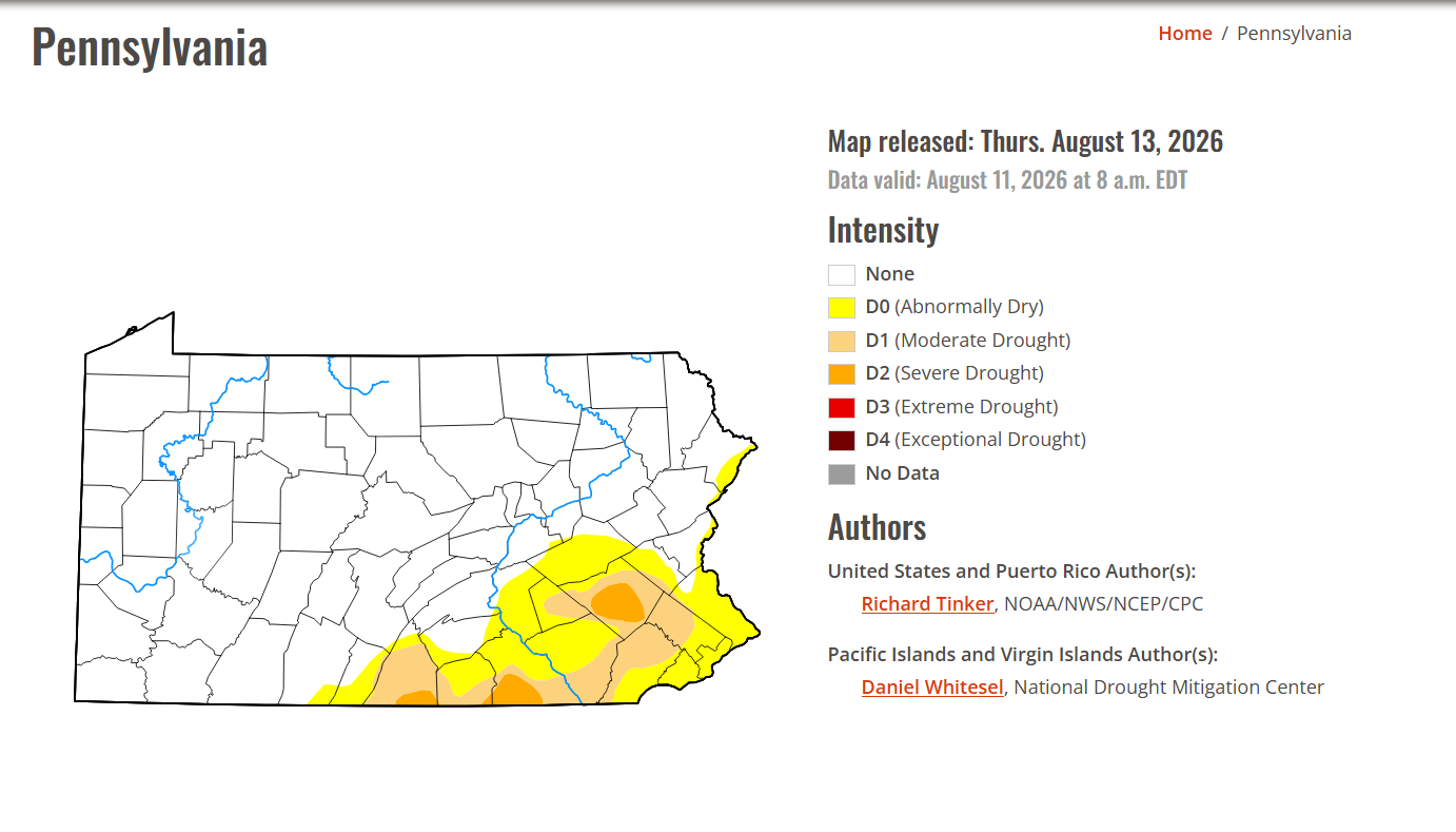
Glad the drought is getting chipped away little by little.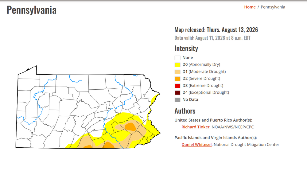
-
For the first run in many days, the UKMET (12Z) has no Atlantic basin TC.
-
My genuine advice is to leave twitter. I got a "brick", which is a horribly overpriced product that locks your phone from accessing apps/websites until you physically retap it, and I went from 15 hours a week on twitter to maybe an hour if a primary election is going on. The dramatic quality of life improvement I've seen is honestly sad. Everyone knows that social media abuses your worst insecurities, desires, and thoughts to keep you scrolling, but you don't realize just how much it effects you mentally. Think about it. After scrolling online how often are you happier for doing so? Imagine how much more time you have afterwards. I've read four books recently with my "new" time. As for the specific comments you've put forth I would argue that social media is not reality and these stories are generated as outrage bait. You will not find a healthy way to process things from social media, that is akin to asking a +NAO, -PNA, -PDO pattern to produce a snowstorm, it just won't happen.
-
Hooray, a sprinkle!
-
I got .15" yesterday, heavy stuff missed to the south and east.
-

2026-2027 Record-breaking El Nino
mitchnick replied to Stormchaserchuck1's topic in Weather Forecasting and Discussion
Intellectual humility has always been my strong point as I'm always humiliating myself in board discussions. So I'm with you there! -
BULLETIN Tropical Storm Lala Advisory Number 9 NWS Central Pacific Hurricane Center Honolulu HI CP012026 Issued by NWS National Hurricane Center Miami FL 500 AM HST Fri Aug 14 2026 ...NEW WATCHES AND WARNING ISSUED FOR THE HAWAIIAN ISLANDS... SUMMARY OF 500 AM HST...1500 UTC...INFORMATION ---------------------------------------------- LOCATION...16.7N 149.5W ABOUT 420 MI...680 KM ESE OF HILO HAWAII ABOUT 635 MI...1020 KM ESE OF HONOLULU HAWAII MAXIMUM SUSTAINED WINDS...60 MPH...95 KM/H PRESENT MOVEMENT...WNW OR 290 DEGREES AT 12 MPH...19 KM/H MINIMUM CENTRAL PRESSURE...997 MB...29.44 INCHES WATCHES AND WARNINGS -------------------- CHANGES WITH THIS ADVISORY: The Tropical Storm Watch for Maui County has been upgraded to a Tropical Storm Warning. A Tropical Storm Watch has been issued for Oahu and Kauai Counties. SUMMARY OF WATCHES AND WARNINGS IN EFFECT: A Hurricane Warning is in effect for... * Hawaii County A Tropical Storm Warning is in effect for... * Maui County, including the islands of Maui, Lanai, Molokai and Kahoolawe A Tropical Storm Watch is in effect for... * Oahu * Kauai County, including the islands of Kauai and Niihau
-
We have central ac, it's not zoned out and our house basks in full sunlight as trees are too far away to shade it. This of course benefits us in winter. And I like the inside temp chilly in summer and not too warm in winter. Plus, in summer I am frequently running a pool pump. For these reasons, summer is also costly for us.
-
Can you do this with your snow shovel this January?
-
Nice out now, 83F with low dews. How to Hi Res models look for this afternoon/evening?
-
Declaring today as The unofficial start to the best two months of weather. Thank you for your attention...
-
if you use 1997/1998 Super enso state as an analog the following 1998 summer was not that hot, 1999 / 202would be the better analog
-
I think its similar overall and depends on what/where youre comparing. 1990, 1992, 1996, 1997,1998 were not hot summers
-
Records: Highs: EWR: 98 (2005) NYC: 99 (1988) LGA: 98 (2016) JFK: 95 (2016) Lows: EWR: 50 (1941) NYC: 54 (1964) LGA: 59 (1964) JFK: 57 (1964) Historical: 1724: The first recorded tornado in Pennsylvania history occurred on this date. It moved from Chester to Bucks County. (Ref. AccWeather Weather History) 1898 - A deadly, estimated F4 tornado moved southeast from 12 miles northwest of Clear Lake, South Dakota, passing 7 miles north of town and ending about 4 miles west of Gary. Deaths occurred on two farms. One man was killed when the kitchen of his farm house was torn off. Five members of one family were killed along with two labors on another farm as every building was swept away. Buildings suffered massive damage on eight farms. This tornado was one of the earliest, estimated F4 tornadoes on record for South Dakota. 1933: Bakersfield, CA reached 117° to set their all-time record for August. Hanford reached 115° for the second day in a row, tying their all-time August high temperature record. (Ref. Wilson Wx. History) 1936 - Temperatures across much of eastern Kansas soared above 110 degrees. Kansas City MO hit an all-time record high of 113 degrees. It was one of sixteen consecutive days of 100 degree heat for Kansas City. During that summer there were a record 53 days of 100 degree heat, and during the three summer months Kansas City received just 1.12 inches of rain. (The Kansas City Weather Almanac) 1953 - Hurricane Barbara hits North Carolina as a Category 2 hurricane. Damage from the storm was relatively minor, totaling around $1.3 million (1953 USD). Most of it occurred in North Carolina and Virginia from crop damage. The hurricane left several injuries, some traffic accidents, as well as seven fatalities in the eastern United States; at least two were due to electrocution from downed power lines. Offshore Atlantic Canada, a small boat sunk, killing its crew of two. 1964: Strong Canadian high pressure pushing a cold front to the Gulf of Mexico brought unseasonable chilly air east of the Mississippi. The following locations recorded their coldest August temperature: Theilman, MN: 32° (also earliest freezing temperature), Mauston, WI: 33°, and Caledonia, MN: 35°. Other daily record lows included: Duluth, MN: 36°, Rochester, MN: 37°, Madison, WI: 37 °F. (Ref. Many Additional Temperatures Listed On This Link) 1969: Tropical Storm Camille formed near Grand Cayman Island. From the beginning, it was evident that Camille would be an explosive storm. First reports from the reconnaissance plane indicated the storm had already reached tropical storm strength with a central pressure of 999 millibars or 29.50 inches of mercury and sustained winds of 55 mph. By afternoon, the storm would already be classified as a hurricane with a central pressure of 964 millibars or 28.64 inches of mercury. (Ref. AccWeather Weather History) 1974: Bethany Beach, Del.--A young girl was killed by lightning as she stood on the beach. Lehigh Acres, Fla.--Lightning struck four workers as they were preparing to leave a road-construction site. Killed one, injured three. (Ref. Lightning-The Underrated Killer.pdf) 1980: National Airport had a 98° high temperature today the last of 21 consecutive days of 90°F or more. (Ref. Washington Weather Records - KDCA) The temperature reached the century mark for the 53rd time in Dallas, TX, establishing the all-time record for 100 degree plus days in a year. (Ref. AccWeather Weather History) 1987 - Slow moving thunderstorms deluged northern and western suburbs of Chicago IL with torrential rains. O'Hare Airport reported 9.35 inches in 18 hours, easily exceeding the previous 24 hour record of 6.24 inches. Flooding over a five day period resulted in 221 million dollars damage. It was Chicago's worst flash flood event, particularly for northern and western sections of the city. Kennedy Expressway became a footpath for thousands of travelers to O'Hare Airport as roads were closed. The heavy rains swelled the Des Plaines River above flood stage, and many persons had to be rescued from stalled vehicles on flooded roads. (13th- 14th) (The National Weather Summary) (Storm Data) (The Weather Channel) 1988 - Eighteen cities in the northeastern U.S. reported record high temperatures for the date, and the water temperature at Lake Erie reached a record 80 degrees. Portland ME reported a record fourteen straight days of 80 degree weather. Milwaukee WI reported a record 34 days of 90 degree heat for the year. Afternoon and evening thunderstorms resulted in about fifty reports of severe weather in the northeastern U.S. One person was killed at Stockbridge MI when a tornado knocked a tree onto their camper. (The National Weather Summary) (Storm Data) 1989 - Afternoon thunderstorms in Illinois soaked the town of Battendorf with 2.10 inches of rain in thirty minutes. Evening thunderstorms in Montana produced wind gusts to 66 mph at Hobson. (The National Weather Summary) (Storm Data) 1996: Arizona recorded its record wind gust of 114 mph at the Deer Valley Airport on the north side of Phoenix as a severe thunderstorm downburst hit the area. (Ref. Wilson Wx. History) 2002: A 594 decameter area of high pressure off the Carolina coast produced hot south to southwesterly winds ahead of a cold front bringing record heat to parts of the east. The temperature in Boston, MA reached 101°, equaling their August record (8/2/1975). Other daily records included: Syracuse, NY: 101°, Concord, NH: 99°, Hartford, CT: 99°, Allentown, PA: 99°, Philadelphia, PA: 99°, Milton, MA: 98°, Providence, RI: 98°, Rochester, NY: 97°, Harrisburg, PA: 97°, Burlington, VT: 96°, Binghamton, NY: 95° and Erie, PA: 94°. (Ref. Wilson Wx. History) In San Angelo, TX, just after midnight, a descending heat-burst jumped the temperature from 75° to 94° in 30 minutes. The event ended about 90 minutes later when the temperature fell back to 73°. (Ref. Wilson Wx. History) (Ref. WxDoctor) 2004: Hurricane Charley made a second landfall near North Myrtle Beach, South Carolina, on August 14. 2009: (June/28-Sep/6) Iowa temperatures averaged above normal only 10 days in this 71-day period. July’s 68.1 degree average became the coldest July in 137 years of record (old: 68.3 degrees in 1891). The last greater or equal 90 degree noted in IA this year was today – the earliest of record (old: 19th in 1902). (Weather Guide Calendar with Phenomenal Weather Events 2011 Accord Pub. 2010, USA) 2016: August 9-16. Weak low pressure combined with abundant Gulf moisture produced phenomenal rainfall and flooding across central Louisiana, inundating entire neighborhoods and towns, especially around Lafayette and Baton Rouge. Rainfall totals exceeded 20 inches in as little as two days. Thirteen people died and economic costs ranged from $10 to $15 billion.
-
85 / DP 61. Variable clouds. Warm and the sunnier spots may tough 90. Cooler but dry Saturday and split with rain on Sunday. Sort of back and forth overall warmer with warm 8/17 - 8/19 then back near normal and a split beyond there on whether the heat builds back east and north into our region 8/24 and beyond.
-

2026 Spring/Summer Mountain Thread
Maggie Valley Steve replied to Buckethead's topic in Southeastern States
We have a Slight Risk for Excessive Rainfall this afternoon and tonight.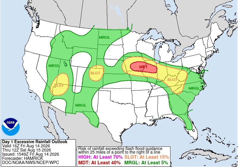
-
It was cloudy again here last night. We had that nice airmass come in on Wednesday with sunny skies and low humidity, yet we couldn't get one clear night for the meteor shower. Terrible luck. Complete bust here this year for the Perseids. Hopefully we'll have much better luck for the Geminids in December. Of course there are a few smaller meteor showers before then.
-
 Generic Viagra for sale: MenCare Virtual - Viagra online price
 -
Sometimes it pays to be a weather nerd.... cut the lawn and put some fertilizer down... now it's raining on schedule. Gotta love it!
- Today
-

Central PA Summer 2026 Discussion/Obs Thread
mahantango#1 replied to Voyager's topic in Upstate New York/Pennsylvania
I think that too he was screwed over at PSU McCarthy and other Steelers brass seen something great in him. -

Augdewst 2026: Summer's Last Stand
dendrite replied to Prismshine Productions's topic in New England
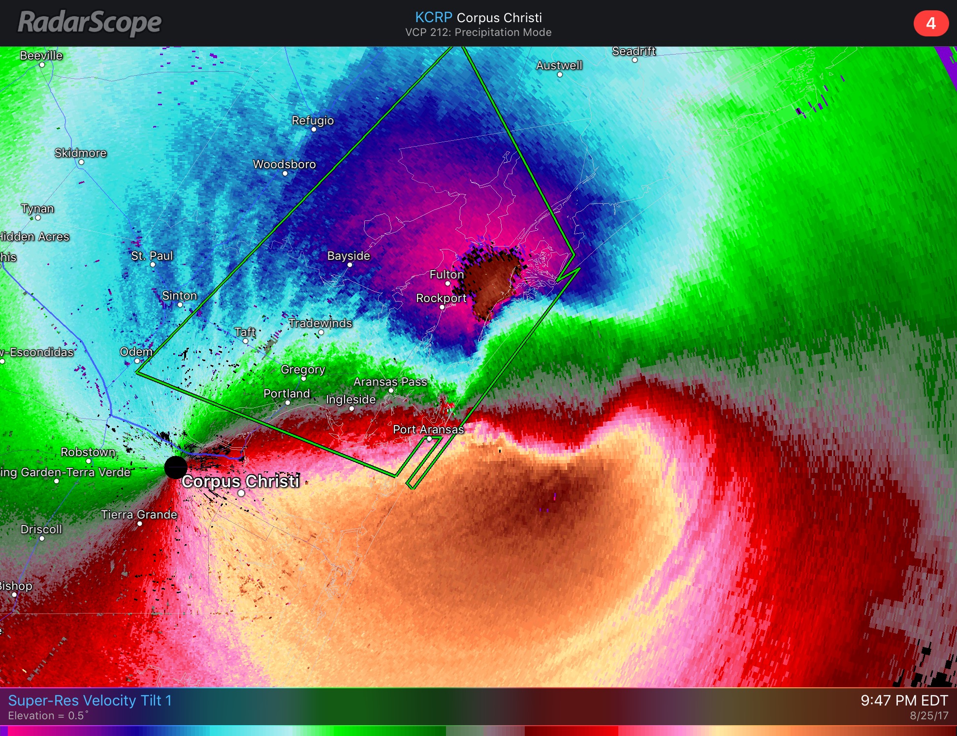
Here’s an old velocity image I have from Harvey from 9 years ago. CRP radar is due west of landfall so the radials extending eastward are giving you near 0 velocity since all of the wind east of the low are S and west of the low are N and nothing is going to, or away, from the beam.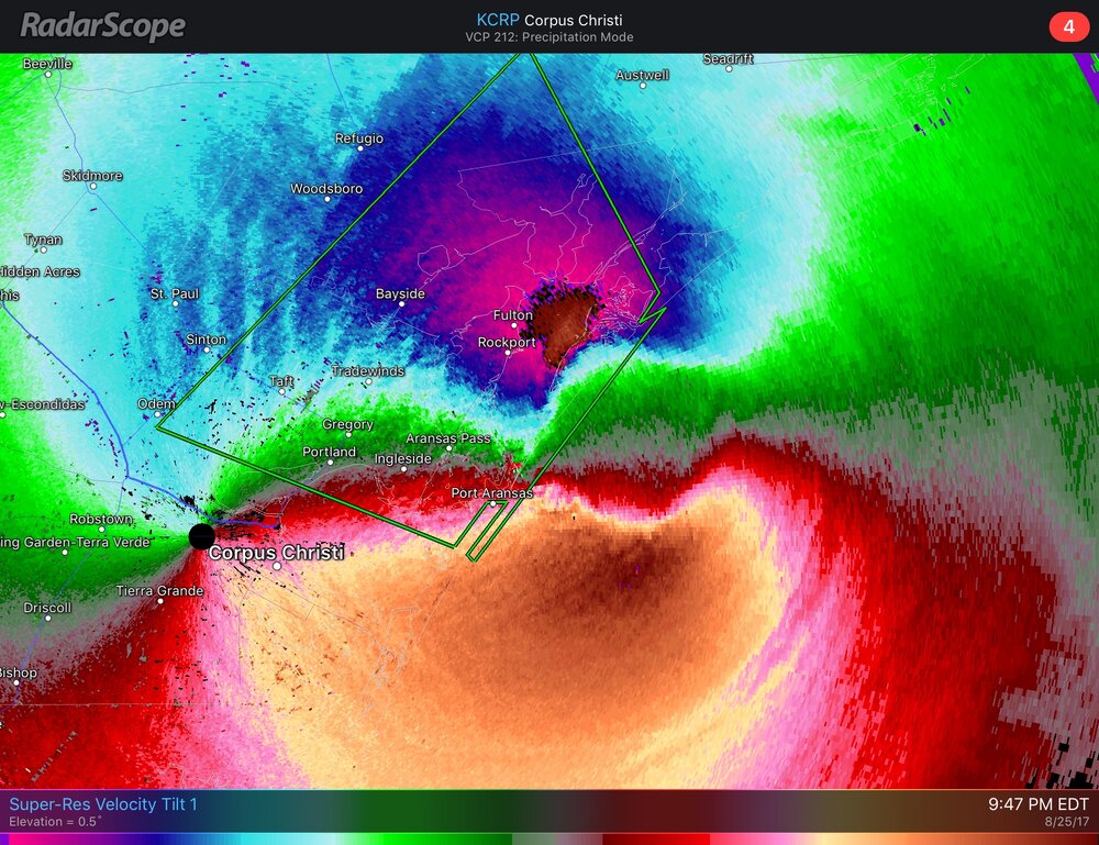
-
Ryan explains it here. Looks like he updated it as well with another nearby weather station recording a 97 mph gust. "A nearby personal weather station recorded a gust to 97 mph in Morgan Point (East Haven)" https://ryanhanrahan.substack.com/p/incredible-103-mph-wind-gust
-

2026-2027 Record-breaking El Nino
GaWx replied to Stormchaserchuck1's topic in Weather Forecasting and Discussion
In the 1980s soon after obtaining my first job in my field of study, my first big purchase was for a washer/dryer. I was so excited. But I was even more excited with my 2nd buy, an even bigger one: what my friends called a “weather machine”. This “machine” was a combo of the following: a pretty high end short wave radio to get radio facsimile sounds, an Epson dot matrix B/W printer, and a radio facsimile decoder that was sent to me from England. This was a dream come true. The output wasn’t that good as weak or interfered signals were common, but this was the only way I could get my own feed of wx data!