All Activity
- Past hour
-

Saturday 9/6 Strong/Severe storm potential
ma blizzard replied to Torch Tiger's topic in New England
2.06” -
Half inch from the first batch. In a bit of a notch now but looks like more to come just to the west.
-
Dumping now!
-

Saturday 9/6 Strong/Severe storm potential
FlashFreeze replied to Torch Tiger's topic in New England
just saw this from Winnisquam Lake apparently taken a few hours ago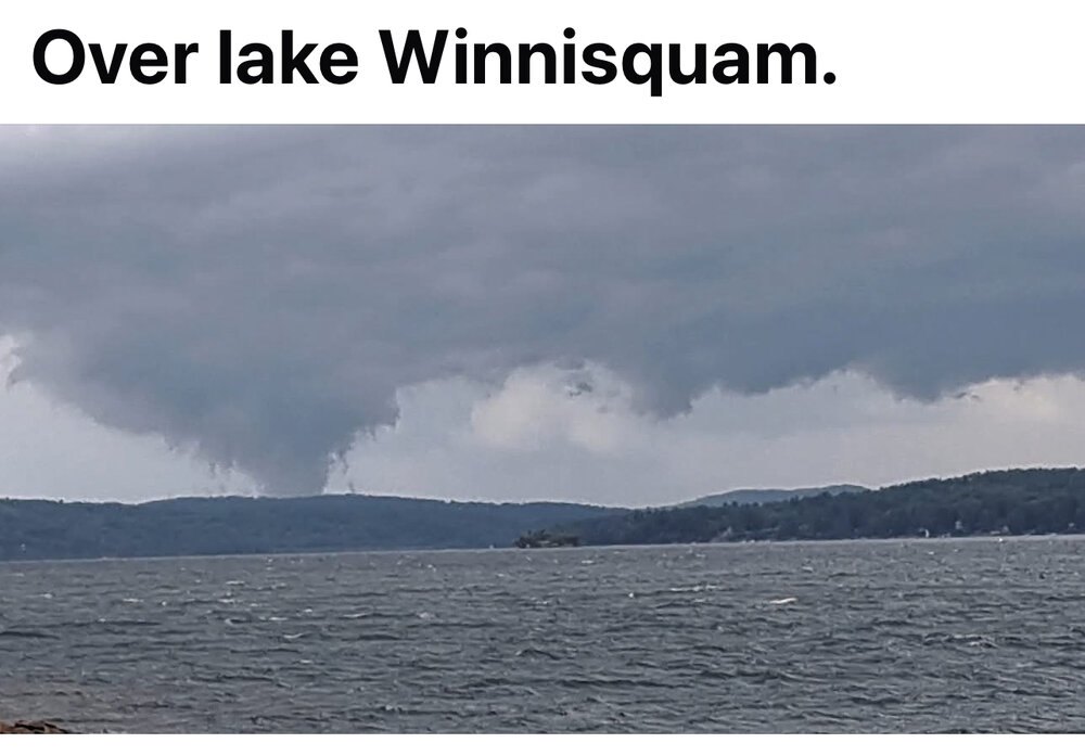
-

September 2025 OBS-Discussion centered NYC subforum
FPizz replied to wdrag's topic in New York City Metro
Worst stayed south -
Neighbor down the road is measuring .93, perfect. Hopefully a bit more tomorrow and should be good for fall lawn, as long as we don't go full on stein.
-

Saturday 9/6 Strong/Severe storm potential
CT Valley Snowman replied to Torch Tiger's topic in New England
We had about 1" in this area on several Weather Undergound stations. Definitely looked more robust on radar to the north. -
After tonight looks like a solid week of lows in the 40s here in the N ORH hill towns.
-

Saturday 9/6 Strong/Severe storm potential
codfishsnowman replied to Torch Tiger's topic in New England
No Stein issues here. Well over an hour of heavy rain with some thunder and lightning. A few gusts and marginally threatening sky before the deluge. I'm thinking close to two inches of rain....lots of minor flooding/ponding on roadways -

E PA/NJ/DE Autumn 2025 Obs/Discussion
Birds~69 replied to PhiEaglesfan712's topic in Philadelphia Region
Underachiever... -
mod-heavy rain just started here. looks like isolated 2.5-3 inches just WNW of here in MD. line just got redder on radar.
-
Had a hell of a close CG.
-

Saturday 9/6 Strong/Severe storm potential
Torch Tiger replied to Torch Tiger's topic in New England
lol -
Saturday 9/6 Strong/Severe storm potential
Torch Tiger replied to Torch Tiger's topic in New England
Glad you got in on it! Faster timing worked out -
It is freaking pouring
-

2025-2026 ENSO
PhiEaglesfan712 replied to 40/70 Benchmark's topic in Weather Forecasting and Discussion
Classic case is 2011. That was a cold October, with a snowstorm at the end of the month. Pattern flipped soon thereafter, and it was blowtorch from November through March. -
Very dark here with a few good rumbles. I think the skies are gonna open up very soon!
-
What a hilarious set of misses all day for the most part in Fallston.
-

September 2025 OBS-Discussion centered NYC subforum
psv88 replied to wdrag's topic in New York City Metro
Yup. Only the GFS had this -

Saturday 9/6 Strong/Severe storm potential
DavisStraight replied to Torch Tiger's topic in New England
Held off up here once I heard the forecast. -
Brutal. Pretty rare I get bailed out on the coast and you get split. Stratus looks around 0.60", which is more than I've had since 8/1. I'll take it. Shit, I would've taken the 0.32 or whatever Lava meh'd!
-
this second line has fantastic rain rates without the wind, and some pretty good thunder....impressed....my plants and lawn needed this
-

Saturday 9/6 Strong/Severe storm potential
Damage In Tolland replied to Torch Tiger's topic in New England
New seed and lawn washed . Training cells -
For the first 2 Minutes, was of the Most Intense Rain Is ever seen, but then went to general heavy rain. Some lightning, not too much.
-

September 2025 OBS-Discussion centered NYC subforum
uofmiami replied to wdrag's topic in New York City Metro
So much for the models having nothing for Suffolk GFS is looking good


