All Activity
- Past hour
-
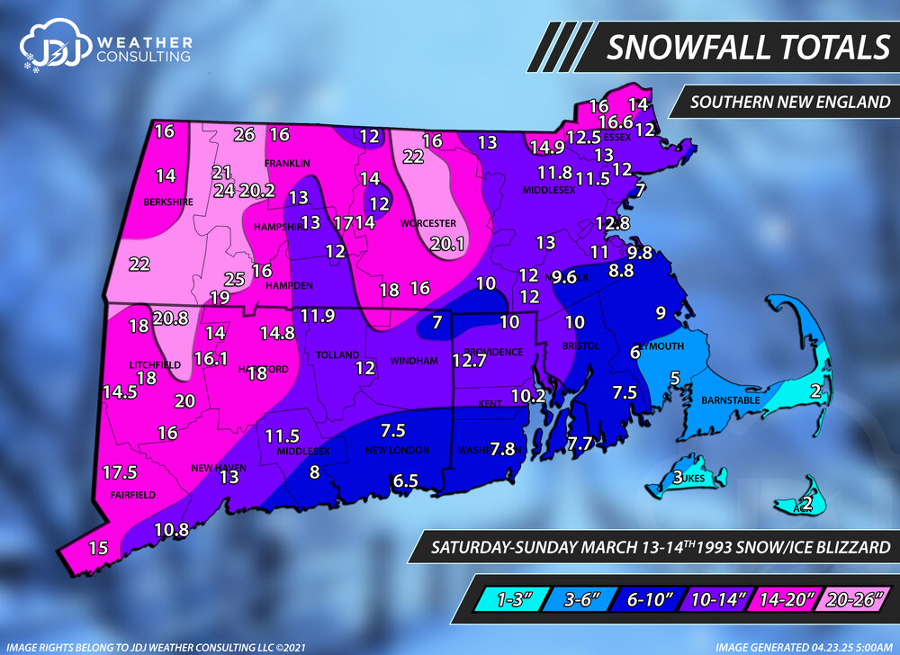
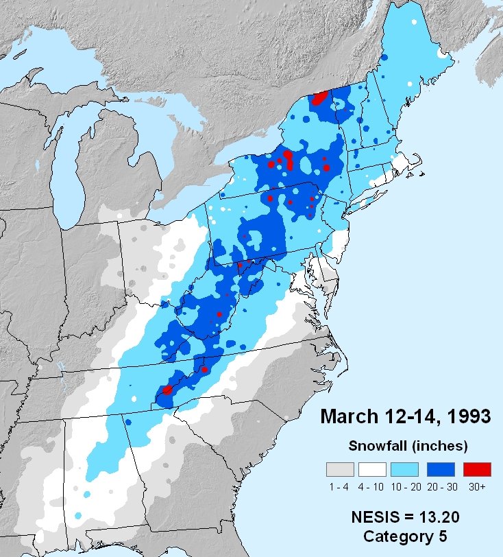
1993 wasnt that bad for E areas. 8.8 from weymouth COOP at the time. obv west was best, but it was a good front ender for nearly everyone except for the Cape

-

Pittsburgh/Western PA WINTER ‘25/‘26
colonel717 replied to Burghblizz's topic in Upstate New York/Pennsylvania
Great runs by the 0z models. From 22nd through 26th looks loaded with potential. And that is after I think we get a few good surprises next few days. -

First Legit Storm Potential of the Season Upon Us
Torch Tiger replied to 40/70 Benchmark's topic in New England
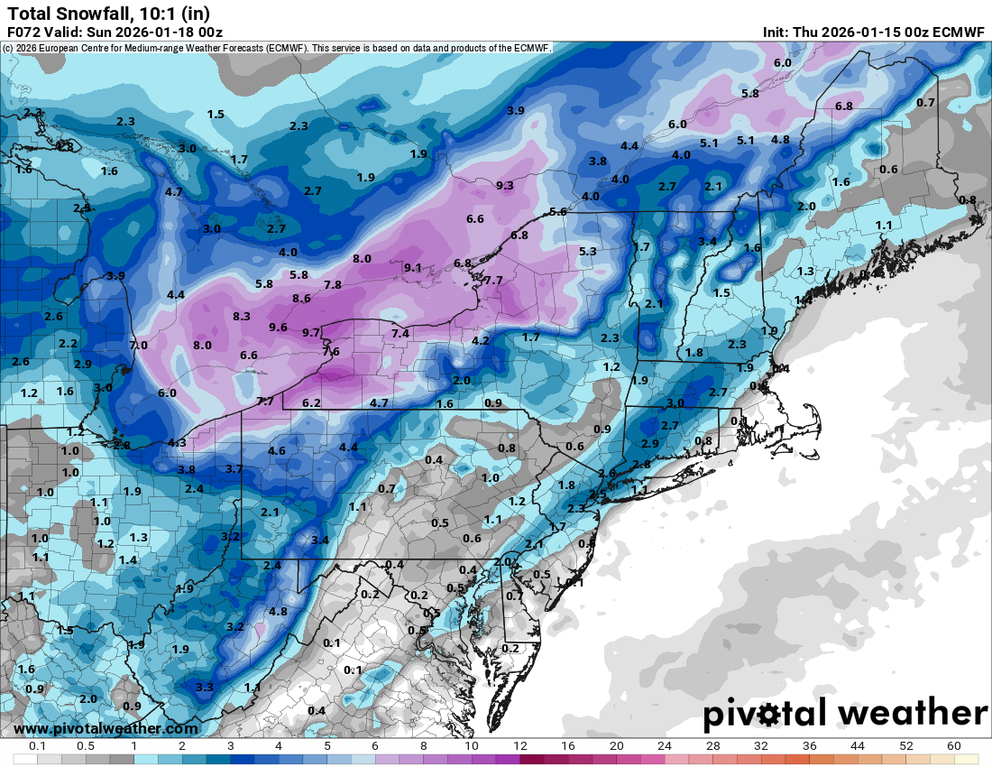
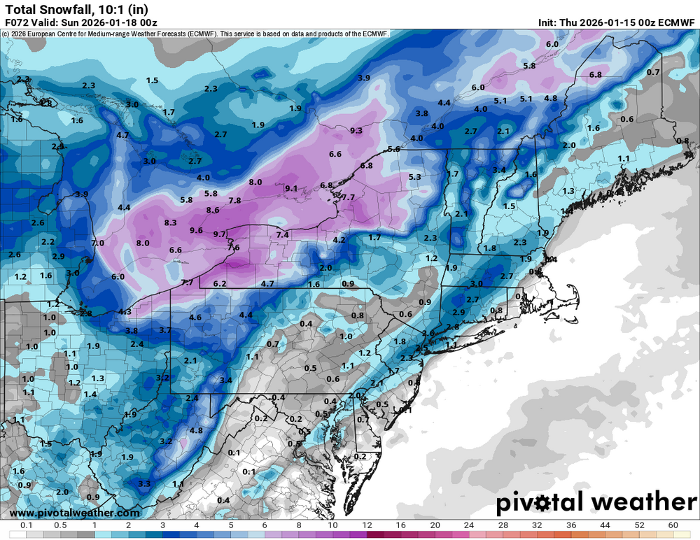
looks like a decent-moderate snower for ENE, and maybe further west. 5-10"er? overall, the ceiling seems low because of the fast flow -
Best eps spike of the year
-
Dude has changed dramatically in the past year or so. Idk if the station or something has pressured him to drive engagement or what, but it’s become incessant with the hype posts. Still a good Met but this has made me distrust him some.
-

January 2026 Medium/Long Range Discussion
Stormchaserchuck1 replied to snowfan's topic in Mid Atlantic
Nice pattern. Not real strong anomalies, but things are where you want them for cold/snowstorms right in the middle of Winter. -

Storm potential January 18th-19th
SnoSki14 replied to WeatherGeek2025's topic in New York City Metro
Hard disagree. There's nothing to stop it from trending NW -
EPS is snowier for weekend and next 2 weeks in total
-

First Legit Storm Potential of the Season Upon Us
WeatherGeek2025 replied to 40/70 Benchmark's topic in New England
GM it'll go west gfs is king in my ok no opinion. Euro isn't as good as before they made that upgrade -
January 2026 Medium/Long Range Discussion
Stormchaserchuck1 replied to snowfan's topic in Mid Atlantic
Probably a wintery pattern shaping up. Here is the end of 0z GEFS. Nice cold, also looks like some more +PNA getting toward the end of January. My theory that central-ENSO-subsurface warmth (Kelvin wave) correlates with N. Pacific +PNA in the now-time is verifying, at least this time around. -
Pittsburgh/Western PA WINTER ‘25/‘26
colonel717 replied to Burghblizz's topic in Upstate New York/Pennsylvania
Nice squall heading towards South Hills. -
I think it will come back inland.
- Today
-
First Legit Storm Potential of the Season Upon Us
Torch Tiger replied to 40/70 Benchmark's topic in New England
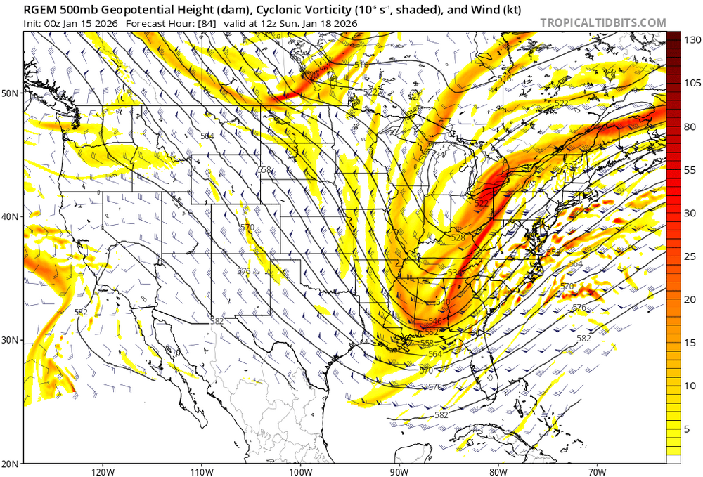
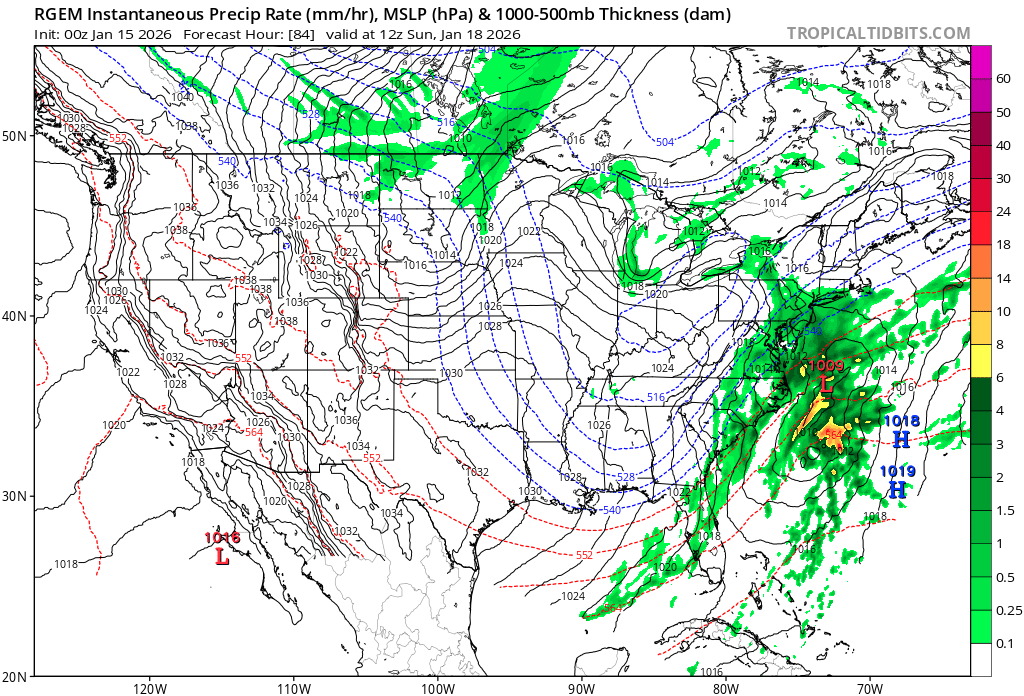
i know it's the latter rgem panels and all, but looking pretty good @ 84.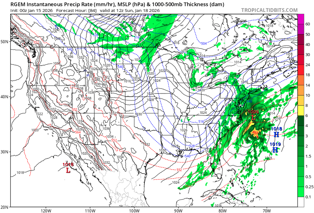
-
I really have not disliked the dry and mild conditions over the last couple weeks. It has allowed the street and sidewalk construction at the end of my street to be completed. I live near the end of a dead end street. They just installed a hammerhead turnaround, which will make it much easier for trucks to turn around, including snow plows. There was a port-o-potty on my property, which was finally removed yesterday.
-
.thumb.png.5a9ebd30ca7e56457ef734c3a17561af.png)
-
The long range isn't exactly inspiring for winter lovers either, the GFSAI is a torch, the EuroAI has a few cold frontal passages but quickly rebounds to AN after each. At this point, I'm going to hope we get a February event, as January (unless the gfs pulls off a miracle coup with the nw trend) is looking lost. The odds of getting a truly wintery pattern with snow on the ground for a while like we've managed the last few years, seem to be fleeting.
-
Euro looks interesting for the 24th through 28th
-

Winter 2025-26 Short Range Discussion
KeenerWx replied to SchaumburgStormer's topic in Lakes/Ohio Valley
Lake scraps as I’m winding down for the night. Maybe we get lucky and grab an inch overnight. Regardless, it looks pretty! -
What did it show?
-
Truly don’t understand how the surface depiction is that bad there… It’s a tiny bit more positive tilt than GFS but otherwise they are quite close at H5 to me.
-
Don’t remember tbh.
-

First Legit Storm Potential of the Season Upon Us
brooklynwx99 replied to 40/70 Benchmark's topic in New England
it’s a bit more consolidated and precip is a bit farther west but still, not great -
What was it at 18z?
-
It gives us a 1/2”, and we aren’t far off from more.
-

First Legit Storm Potential of the Season Upon Us
8611Blizz replied to 40/70 Benchmark's topic in New England
It looks way west to me compared to 12z anyway... I can't see 18z


.png.aaf6c080c4c8a9390960c58c96cdff5a.png)