All Activity
- Past hour
-
I second! Love me 430 sunsets and darkness early and driving to work in darkness.
-
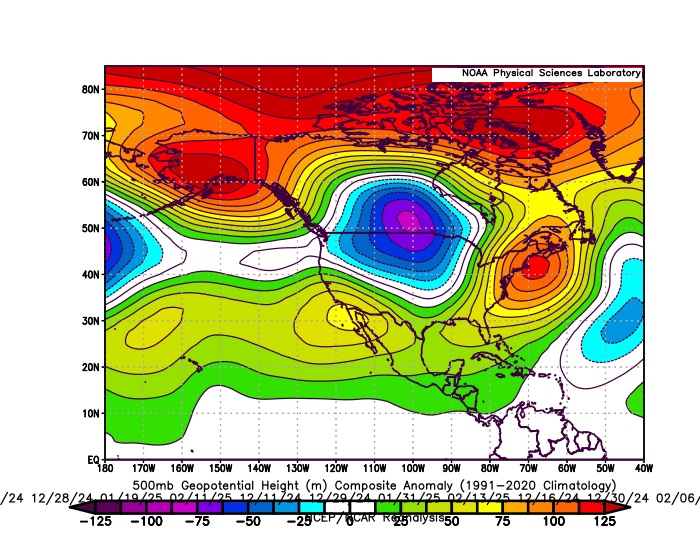
The Greenland block frequently linked up with the Southeast ridge last winter when it actually counted on the days which .20 or greater of precipitation fell. This is why the snowfall totals were so low from Philly to Boston. The average temperature from Philly to NYC was in the low 40s on the 11 days in the composite below. Way too warm of a storm track for decent snows along the I-95 corridor. The winter average was cooler at close to 35° around NYC. But it only arrived following the storms cutting to our west and closely hugging the I-78 to I-84 corridors. 11 day storm composite from Philly to Boston on the 11 days of heaviest precipitation over .20 with strong Greenland block linkage with the Southeast ridge
-
Yes
-
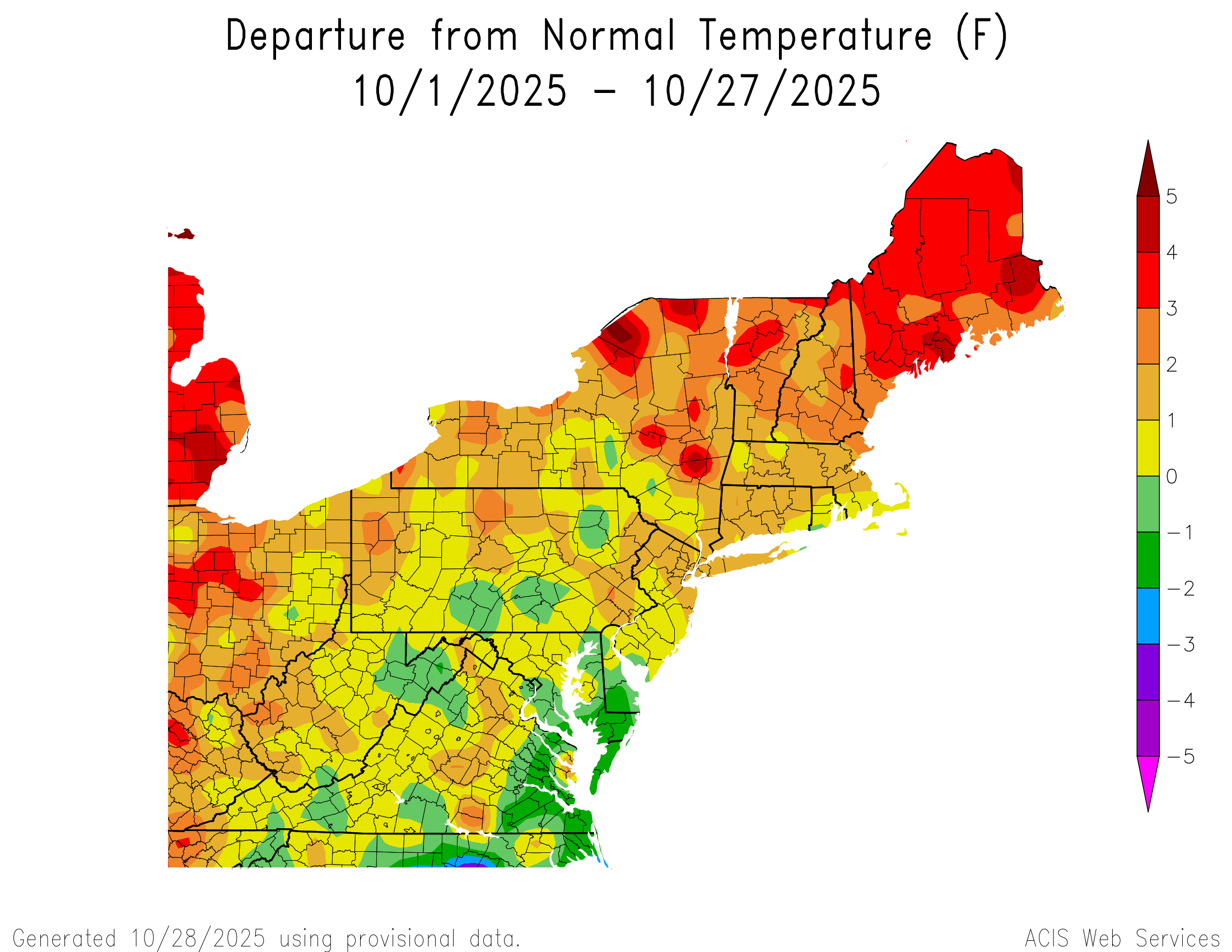
What it is feels like is a bit deceptive since October is one of the fastest warming months of the year. So we have been normalizing how warm it has been getting since it only takes a small + departure to rank in the top 15 warmest Octobers. Sussex NJ is currently ranked 8th warmest October through the 28th. White Plains is 12th warmest and Islip is 12th warmest. It would probably make more sense to use an earlier climate period like 1961-1990 or 1951-2000 as a base period so rankings and departures will actually match up. Instead of updating the normals every 10 years in a rapidly warming climate. This leads to the sense that it isn’t warming as fast as it really is and making the departures less relevant unless they are very high. Time Series Summary for ISLIP-LI MACARTHUR AP, NY - Month of Oct Click column heading to sort ascending, click again to sort descending. 1 2017 61.9 0 2 2021 61.2 0 3 2007 61.1 0 4 1990 60.9 0 5 1971 59.7 0 6 2023 58.8 0 7 2025 58.6 3 8 1995 58.5 0 9 2024 58.4 0 10 1963 58.3 0 11 2019 57.9 0 - 2013 57.9 0 - 2012 57.9 0
-
Garbage pattern starting to take place in order to close off the month. Get ready to be stuck in the 40s all day over the next few days, especially with soaking rains.
-

Spooky Season (October Disco Thread)
CoastalWx replied to Prismshine Productions's topic in New England
I do agree with turn milder after the 9th or so. -
My 5 model blend dropped overnight from 1.96" to 1.44". NBM dropped from 1.75 to 1.20 as would be expected. My sweetspot for significant rainfall seems to be 6 pm to 6 am. I am running a deficit of 7.14" since August 1 !!
-

Central PA Fall Discussions and Obs
canderson replied to ChescoWx's topic in Upstate New York/Pennsylvania
The color has basically sucked so good. -

Spooky Season (October Disco Thread)
Snowcrazed71 replied to Prismshine Productions's topic in New England
You're one strange dude. We've had several mornings now below freezing. And I'm not in an area where you consider me to be remote or up in Northern Vermont. I'm about 12 miles west of Hartford, Connecticut. -

Central PA Fall Discussions and Obs
mahantango#1 replied to ChescoWx's topic in Upstate New York/Pennsylvania
With the projected heavy rain at times and wind gusts projected on some of the models of 40+ we should have a substantial leaf drop till Saturday. -
(002).thumb.png.6e3d9d46bca5fe41aab7a74871dd8af8.png)
Central PA Fall Discussions and Obs
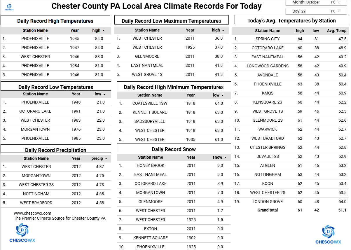
ChescoWx replied to ChescoWx's topic in Upstate New York/Pennsylvania
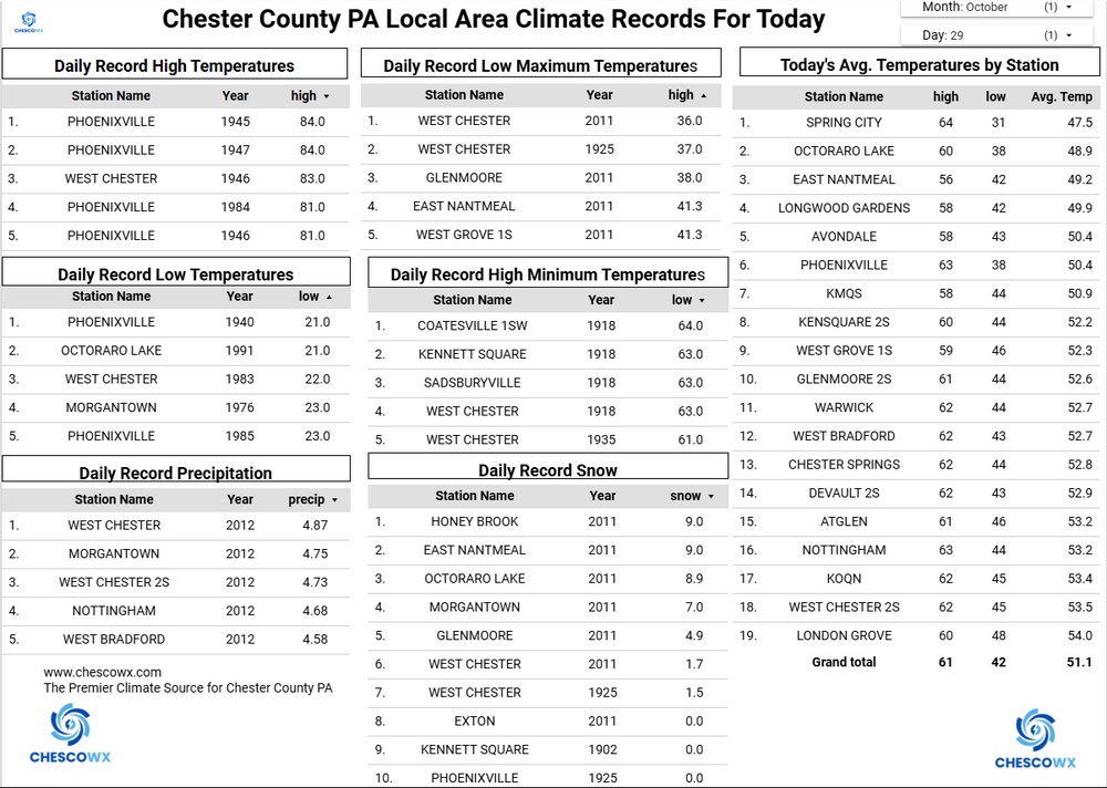
We continue our stretch of chillier than normal weather with our 9th straight day with below normal temperatures. The beneficial rainstorm is still on track to arrive overnight tonight and continue well into tomorrow night. The NWS has much of the area receiving 1.5" to 2.0" of needed rain. Tomorrow looks to be the warmest day of the week with temperatures maybe a couple of degrees above average with highs well up into the 50's to near 60 degrees. We turn chillier again over the weekend but dry.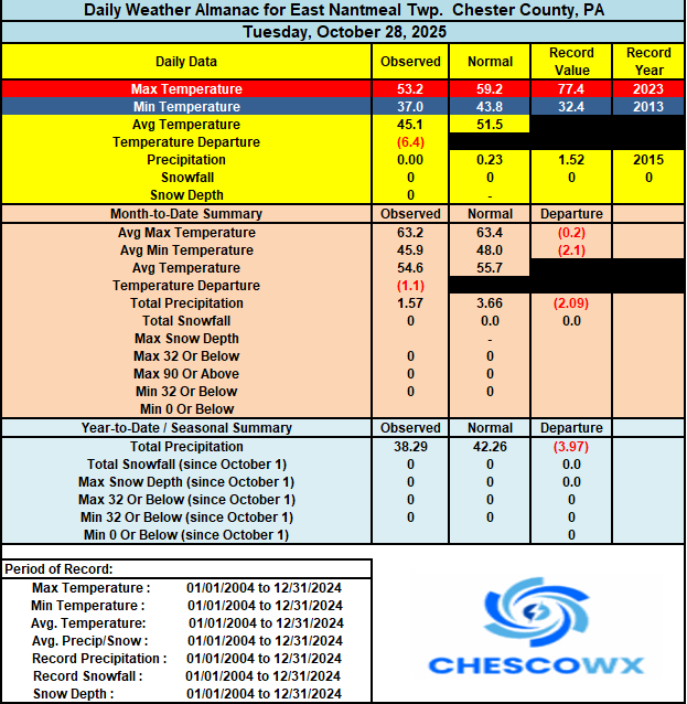
-

Spooky Season (October Disco Thread)
Ginx snewx replied to Prismshine Productions's topic in New England
https://abcnews.go.com/US/mount-washington-hikers-rescued-hypothermia-snow/story?id=126900403 -
E PA/NJ/DE Autumn 2025 Obs/Discussion
ChescoWx replied to PhiEaglesfan712's topic in Philadelphia Region
We continue our stretch of chillier than normal weather with our 9th straight day with below normal temperatures. The beneficial rainstorm is still on track to arrive overnight tonight and continue well into tomorrow night. The NWS has much of the area receiving 1.5" to 2.0" of needed rain. Tomorrow looks to be the warmest day of the week with temperatures maybe a couple of degrees above average with highs well up into the 50's to near 60 degrees. We turn chillier again over the weekend but dry.
-

2025-2026 ENSO
40/70 Benchmark replied to 40/70 Benchmark's topic in Weather Forecasting and Discussion
I don't know about him, but that is Chris' explanation. -

Major Hurricane Melissa - 892mb - 185mph Jamaica landfall
olafminesaw replied to GaWx's topic in Tropical Headquarters
Yikes. This solid brick church was completely destroyed in Black River, like a bomb went off. The kind of damage only storm surge can do https://x.com/nwadeema/status/1983342714986082750/mediaViewer?currentTweet=1983342714986082750¤tTweetUser=nwadeema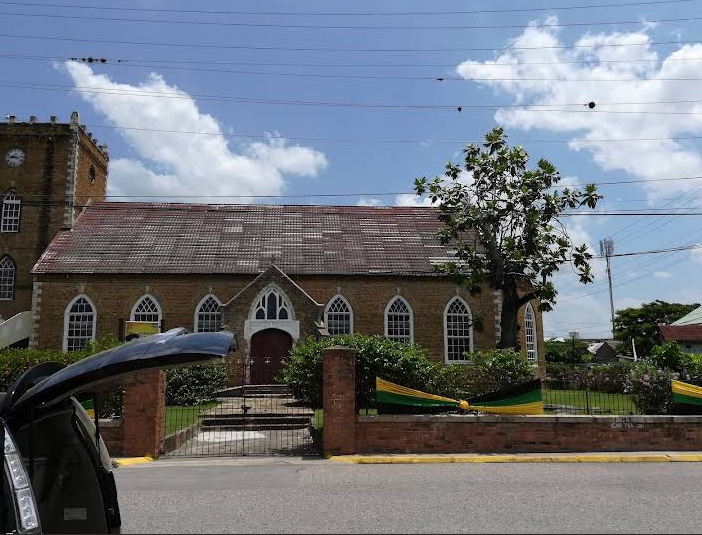
-
The Neg. NAO did not link up with the SE ridge much last winter, unlike previous. Also the Middle Atlantic did well with one of the blocking episodes, unless you are saying that the tendency of blocking to be further south will benefit south of us when it does not not link up. I am still not convinced that this linking did not happen in the past and is something new.
-
Those four days in the 80s added about +1.4 degrees to the monthly average in Central Park, even more in other locations.
-
Major Hurricane Melissa - 892mb - 185mph Jamaica landfall
CoastalWx replied to GaWx's topic in Tropical Headquarters
Some nasty images starting to trickle in. -
 modeling differences with the 06 EPS Suites heavier as well as SPC HREF. If its drier than 1" it would be east of I95, I think . Otherwise all I see is a continued impact event as headlined Thu afternoon. Reality check tomorrow, maybe sooner via modeling, but for now (06z/29 suites)... I see little reason to change anything.
 -
Picked up 0.40" since yesterday. Will finish Oct with 3.60", 3+ inches more than September.
-
1.26” here with a steady drizzle continuing this morning
-

Central PA Fall Discussions and Obs
Jns2183 replied to ChescoWx's topic in Upstate New York/Pennsylvania
I do love October storms like this. Definitely going to sleep tonight with an open window so I can wake up the breezy heavy rain bands. The only thing better would to have winds Friday at the same time as the rains. I have multiple family members in Massachusetts and have had the pleasure of experiencing big noreasters in Gloucester, South Shore, and central Highlands. Only rainstorms unfortunately but man oh man. Having 40+mph sustained winds for 36 hours in a house a few miles from the ocean was beautiful. You could taste the ocean on that northeast wind. Combined with torrential rain, the sounds that a house from the 1850's makes in a storm like that, a big fireplace, good hearty soup, rye whiskey, and a home bar with 3 taps had me wanting never to leave. I wish we could experience more of the rain/wind combo here at least. Sent from my SM-G970U1 using Tapatalk -
2025-2026 ENSO
40/70 Benchmark replied to 40/70 Benchmark's topic in Weather Forecasting and Discussion
Yes, I do consider that...or have the past year or two. I should have said the west warm pool in addition to ENSO...but what I meant is I don't obsess over finding SST meps that are replica matches around the hemisphere. -
Nobody feels like the October we just had was a warm, above normal month though in the tristate. That four day torch in the first week skewed the averages.
-
Most stations on track to finish October warmer than average as this is another month with Canada being so warm that areas to our north will finish warmer again relative to the means. POU…..+0.7 FWN….+1.3 PHL…..+1.7 SMQ….+0.3 NBW….+1.5 EWR….+1.7 NYC…..+0.5 LGA……+0.1 JFK……+1.1 HPN…..+2.2 BDR….-0.3 ISP……+2.4