All Activity
- Past hour
-
July here is 5.1° warmer than June, thanks to the long plateau from 7/6 thru 8/10 in which the average temp varies only 1.1°. I don't have June 1-3, other than the 84 max on the 3rd, warmest on the max-min while we traveled. Though 6/4-22 had 9 BN days and 10 AN, the average is 2.8 AN thanks to the heat of 10-13. When I derive 1-3 (from nearby sites), it's probably about +3 for 1-22. If it finishes there, 6/26 would rank 4th or 5th warmest of 29.
-
70/59 with a nice breeze and the sun returned. Measured 0.54" yesterday with 3.55" for the month so far.
-
1.24” for the day, maybe another storm this evening?
-
My uncle has a place in Tuftonboro and they had a microburst there a few years ago. Just a few hundred yards from his property.
-
Lets rip in an MCS from Canada
-

E PA/NJ/DE Summer 2026 Obs/Discussion
JTA66 replied to PhiEaglesfan712's topic in Philadelphia Region
Little more than 0.25" on the day so far. Doesn't do much for the drought but hopefully it will keep the lawn from getting any browner for a few days. 66F/DP 65F -
About 1.2” yesterday and today. Wayyy better than I expected after failing yesterday.
-
Finally getting some decent moderate rain on the south shore. .
-
https://partnerservices.nws.noaa.gov/products/cache/174-2026/PNSOKX/eeeb3abe685ed84229687420768546b6
-
.43”
-

Occasional Thoughts on Climate Change
donsutherland1 replied to donsutherland1's topic in Climate Change
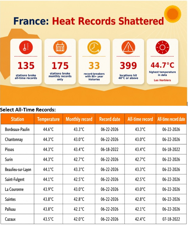
It was a surreal day in France. The air was "a furnace breath." The "heatquake" toppled, shattered, and demolished more than 100 all-time high temperature records. June 2026 has surpassed June 2019 for setting the most all-time record highs in the month of June.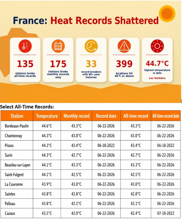
-
The forecast was for "showers." I don't think nonstop rain since 8 a.m. really qualifies as a shower.
-
Yeah, the tornado watch day. It's not like I wasn't watching it closely, but it's a real kick in the groin when I look back and see I dropped an image in Slack for the media partners at 4:10 pm saying this was an interesting looking line break and probably about as far north as the instability would support a tornado risk. Yet it was still too broad for me to issue a tornado warning. Remains to be seen if it was a tornado. It just as easily could've been a microburst that expanded out into Tuftonboro. There is a relatively straight line of damage, but as it left Winni the damage was over 2000 ft wide. That's pretty large for a QLCS tornado.
-
- Today
-
GWDLT Hopefully the circulation around the coop had something to do with it. Welch was also hit hard. Lots of open lake for that SW wind right into Cow too. It’s all in line with that path of higher wind.
-

Central PA Summer 2026 Discussion/Obs Thread
canderson replied to Voyager's topic in Upstate New York/Pennsylvania
Wild. No rain here today and the sun is poking out now. -

2026-2027 Super El Nino
PhiEaglesfan712 replied to Stormchaserchuck1's topic in Weather Forecasting and Discussion
PDO in developing strong/super el nino years 1957 -1.31 -1.57 -0.83 -0.81 -0.02 1.53 0.59 0.34 1.84 1.72 1.54 0.46 1965 -0.95 -0.61 -0.17 -0.01 -0.66 -0.76 -0.74 0.32 0.83 0.30 0.47 0.25 1972 -2.12 -1.95 -1.53 -1.70 -2.16 -1.84 -1.48 -0.11 -0.20 -0.22 -0.05 -0.37 1982 0.11 -0.19 -0.37 -0.70 -1.21 -0.99 0.12 -0.08 0.51 0.15 -0.60 0.16 1986 1.04 1.47 1.68 1.21 0.85 0.62 1.05 -0.19 -0.03 1.00 1.68 1.71 1991 -1.80 -1.09 -1.11 -1.63 -1.65 -2.25 -1.57 -0.58 0.37 0.41 0.56 -0.21 1997 0.44 0.29 0.39 0.73 1.59 2.55 1.49 2.27 1.80 1.78 1.48 0.99 2009 -1.81 -1.78 -2.06 -2.23 -1.32 -0.73 -0.71 -0.49 0.33 -0.13 -0.94 -0.51 2015 1.51 1.52 1.33 0.90 0.32 0.82 1.41 0.98 0.97 0.84 0.17 0.29 2023 -1.24 -1.65 -2.45 -3.08 -2.41 -2.55 -2.54 -2.48 -2.99 -2.23 -1.79 -1.66 -
.52” not too bad for a nice steady rain since this morning.
-
And never Ossipee? The Weymouth of the North!
-

E PA/NJ/DE Summer 2026 Obs/Discussion
Hurricane Agnes replied to PhiEaglesfan712's topic in Philadelphia Region
I did ultimately finish up with 2.56" for day 1, mostly due to getting under several cells. Made it up to 86 for a high after a 67 low, before the rain knocked that down. With today's light overrunning precip., I have picked up 0.23" so far for a 2-day total o 2.79" and monthly total of 6.15". Despite that, I heard on the radio yesterday that we are still experiencing drought conditions here in the city (below as of the last update) - Currently light rain and 66 with dp 66. -
It’s always Tuftonboro
-
I'm glad you brought up temp anomalies. This may have been mentioned prior, but I think the temp sensor at BOS is running at least 1 F too warm. Through 6/22, Logan is running 5.4 F above avg for the month. No other long-term climate location in New England is higher than 3.9 above for the month. Examples: PVD 3.9, ORH 3.8, CON 3.4,and BDL 2.1 above avg for the month so far. And I did a check of May. BOS +2.4, but PVD +1.1, ORH -0.3, CON -0.4, and BDL -0.6. This discrepancy may go back further. This goes to show that even 1 F off for temp is a big deal when over an extended period, and that significance increases as you get further out. 1 F avg higher for a year is more significant than 1 F higher than avg for a month, as one example. See how wx sensor issues, never mind UHI, can skew temp records and easily give an unrealistic picture of trends if not addressed in a timely fashion? Temp sensor calibration and other issues are nothing new, EWR had a +2 F bias for a few years this decade. I think it is corrected now, but it was *so* obvious there was an issue. Every month, EWR was 2 F warmer than NYC, LGA, and JFK, and the distance from EWR to all 3 of these locations is 20 mi or less, so no way EWR did not have a warm bias. Sometimes a warm bias at location is due to new construction nearby or the temp sensor re-located, and in both cases artificial heat sources contaminate the temp readings. What's worse, most of the time, these obvious errors go into the official climate record uncorrected. See the issue here? When wx stats are reported to us, we assume that they are accurate. Not always, and systemic errors do add up over time and can make a big difference. But rarely do you see any outlet, big or small, mention the margin of error/uncertainty in measurements or note there is a problem at a site. And one important item that complicates the issue. ASOS/AWOS are designed primarily for *aviation* use. This means VIS, cloud cover/height, wind, and altimeter take precedence, and T/Td are secondary. And most climate sites in the U.S. and globally are located at airports, which is not ideal due to UHI and proximity to large swaths of asphalt and jet exhaust. So being skeptical of the temp records and trends are certainly justified, and the bias is warmer, not cooler, so the large-scale warming that has occurred is not as high as it is said.
-

-
Finally able to enjoy sitting on the screened porch with a steady, moderate rain. I hope it goes all afternoon. Temp a moist 68
-
When was this? The big tor day that CoastalWx was all excited about recently? LOL.

.thumb.JPG.418e8a9a2902ae687ec35ff4bc0e038e.JPG)