All Activity
- Past hour
-

Hoisting the Sultan Signal: Heavy Rain Event July 5-7
WinterWolf replied to WxWatcher007's topic in New England
There’s been some prolific ones. August of ‘24 for western CT. -
This was our most extreme period around July 4th with record heat, damaging winds causing power outages, and torrential downpours leading flooding.
-
Over 2" here now, 1.70" since midnight. Yard is starting to flood.
-

Hoisting the Sultan Signal: Heavy Rain Event July 5-7
Damage In Tolland replied to WxWatcher007's topic in New England
Everything you saiid there( I actually read it all due to the brevity ) Is true. It’s been light , steady with a quick burst of two minutes of moderate then back to light and at times nothing more than spits on the windshield. . A total boring meh event except NYC west and south -
yeah this was always going to be hit or miss just based on the set up and where boundaries set up -- I was actually surprised at how much coverage there was of moderate rain last night and obviously now we're seeing some incredible downpours across parts of the region.
-
There's always winners and losers in these setups. The flooding is usually in a fairly small area that's hard to pinpoint ahead of time. Kind of in the middle here.
-
You and SNY are winning this one so far. I'm just reaching 3" since 10pm last night.
-
Congrats to thise on the coast and LI, another hyped up event here and hardly gotten much.
-
And that training rain doesn't seem to be in a hurry to go anywhere -- going to be another crazy day of reports across the region.
-
0.95" here seems like the actual heavy stuff is hitting the city and nassau more but it looks like its making its way into western suffolk now unless it fizzles out
-

E PA/NJ/DE Summer 2026 Obs/Discussion
LVLion77 replied to PhiEaglesfan712's topic in Philadelphia Region
Definitely did not verify for the Lehigh Valley. -
Unfortunately, the BLM site is offline. Observations would be helpful.
-
it's too far north. NJ and LI are the bullseye
-
Such a bad job it’s insane
-
Major flooding in Monmouth County also.
-
Insane rates long branch area. About 2.5 inches to 3 inches in last hour
-
Radar us deceiving. It is pouring under these yellow and orange echoes. 2"/hr rates
-
Unfortunately, where the worst of the drought is in South Jersey has seen little to no rain. Cape May still sits at 0 for the event.
-

E PA/NJ/DE Summer 2026 Obs/Discussion
Kevin Reilly replied to PhiEaglesfan712's topic in Philadelphia Region
Anyone have official NWS rainfall totals for the area? I said 2 days ago that the area will see 3-6” of rain Saturday to Monday night and I’m being questioned lol??? -

E PA/NJ/DE Summer 2026 Obs/Discussion
BBasile replied to PhiEaglesfan712's topic in Philadelphia Region
Finally stopped raining. Looks like 1.94" from that round.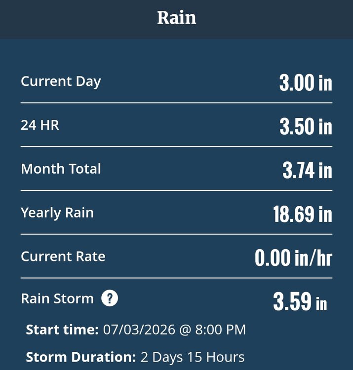
-

Hoisting the Sultan Signal: Heavy Rain Event July 5-7
CoastalWx replied to WxWatcher007's topic in New England
7/10/25 we had 7” in like 3 hrs with most of that in 90 min. -

Hoisting the Sultan Signal: Heavy Rain Event July 5-7
butterfish55 replied to WxWatcher007's topic in New England
Was working in Taunton by route 44 all morning with off and on light rain. Just drove to a job in Brockton with dry roads and breaks in the clouds. Very sharp cut off for rain. -

Hoisting the Sultan Signal: Heavy Rain Event July 5-7
Typhoon Tip replied to WxWatcher007's topic in New England
NAM appears to have already busted too wet in CT through 15Z ... Just a quick eye-balling of rad trends over the morning hours, looks like primarily light right with a few moments in there of moderate have taken place thus far. I can't imagine what's in the rain cans from that rad evolution, matches that plume of QPF the model painted moving through there over the same time - again...just a cursory look over. So those justifying your d-drip highs, please don't be offended. -
So far, both JFK Airport and Islip have set daily rainfall records for July 6th.
-
Its a mess here. Branches all over and flooding everywhere.