All Activity
- Past hour
-
Oh, phew...
-
Some of the maples here in town showing a little color, but that is mainly due to drought stress. Colors may be less robust unless we get good rains coming up.
-
warm and rainy
-
Well, at least 2023 snowed in vermont. 2015 was an utter shut out. Not an accumulating flake even at elevation, and repeated washouts. I'm already mentally prepared for the skiing in northern VT to be garbage this december but there are certainly levels of garbage.
-

Augdewst 2026: Summer's Last Stand
weatherwiz replied to Prismshine Productions's topic in New England
Looks like High Pressure building in late next week behind the passage of the front late Wednesday which would bode well for a dry weekend -

Summer 2026 Med/Long Range Discussion
BeastFromTheEast replied to Brian D's topic in Lakes/Ohio Valley
Labor Day pm a lock to be hot and humid. Summer going out with a bang!! Looking forward to the juiced up storm opportunities too! -
They were both brutal...like...how painful? Slam my the refrigerator door shut on my balls, or kick me as hard as you can?
-
Should I feel honored?
-
Hi guys, hate to interrupt, but my daughter’s getting married 9/5 in Sterling Ct. Ryan’s 10 day looks good, but any thoughts would be greatly appreciated. Cheers
-
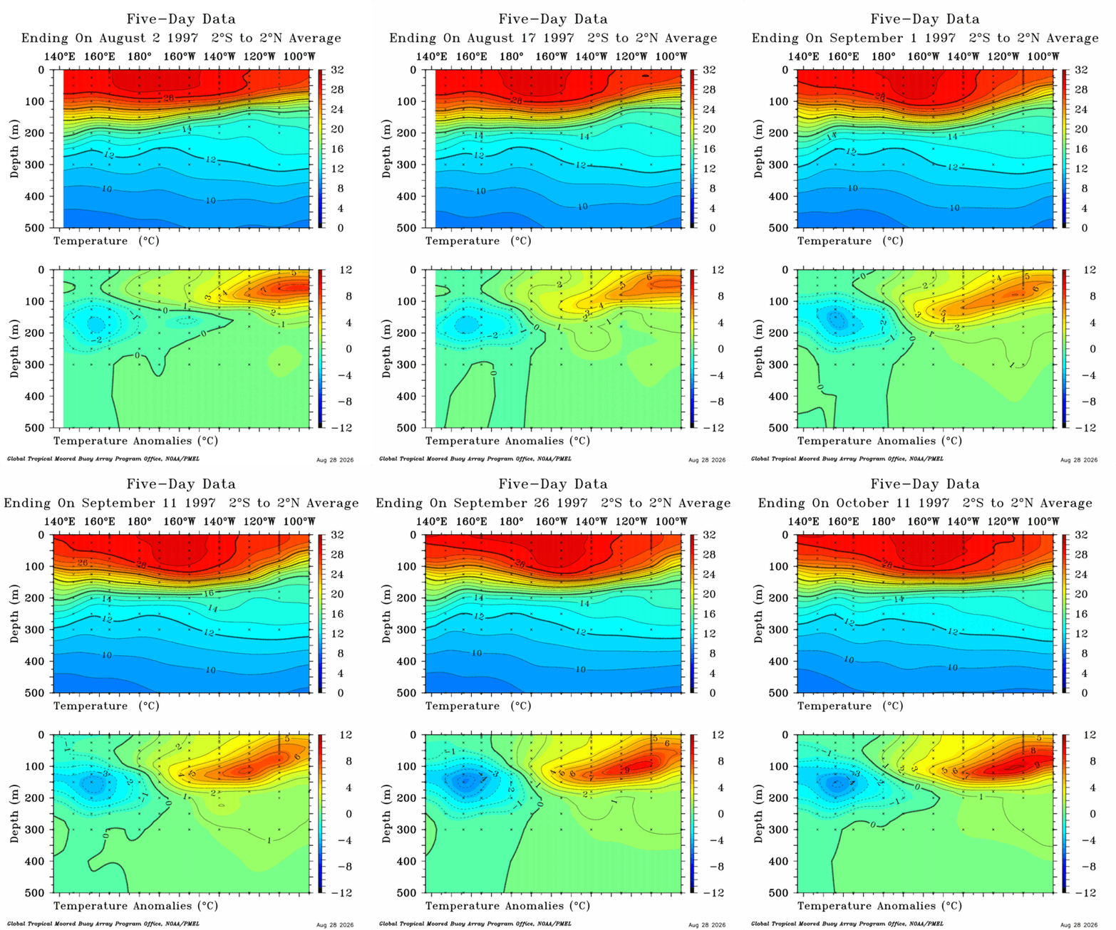
 I will probably have to delete some attachments soon but doing a quick comparison to 1997 and 2026, slightly off time frames but similar process took place and we maybe should see similar results happen? Ill make one for 10-16 to end of 1997 at some point. Shame we have so much cutoff right now. Open up new window and check them side by side to get a better comparison.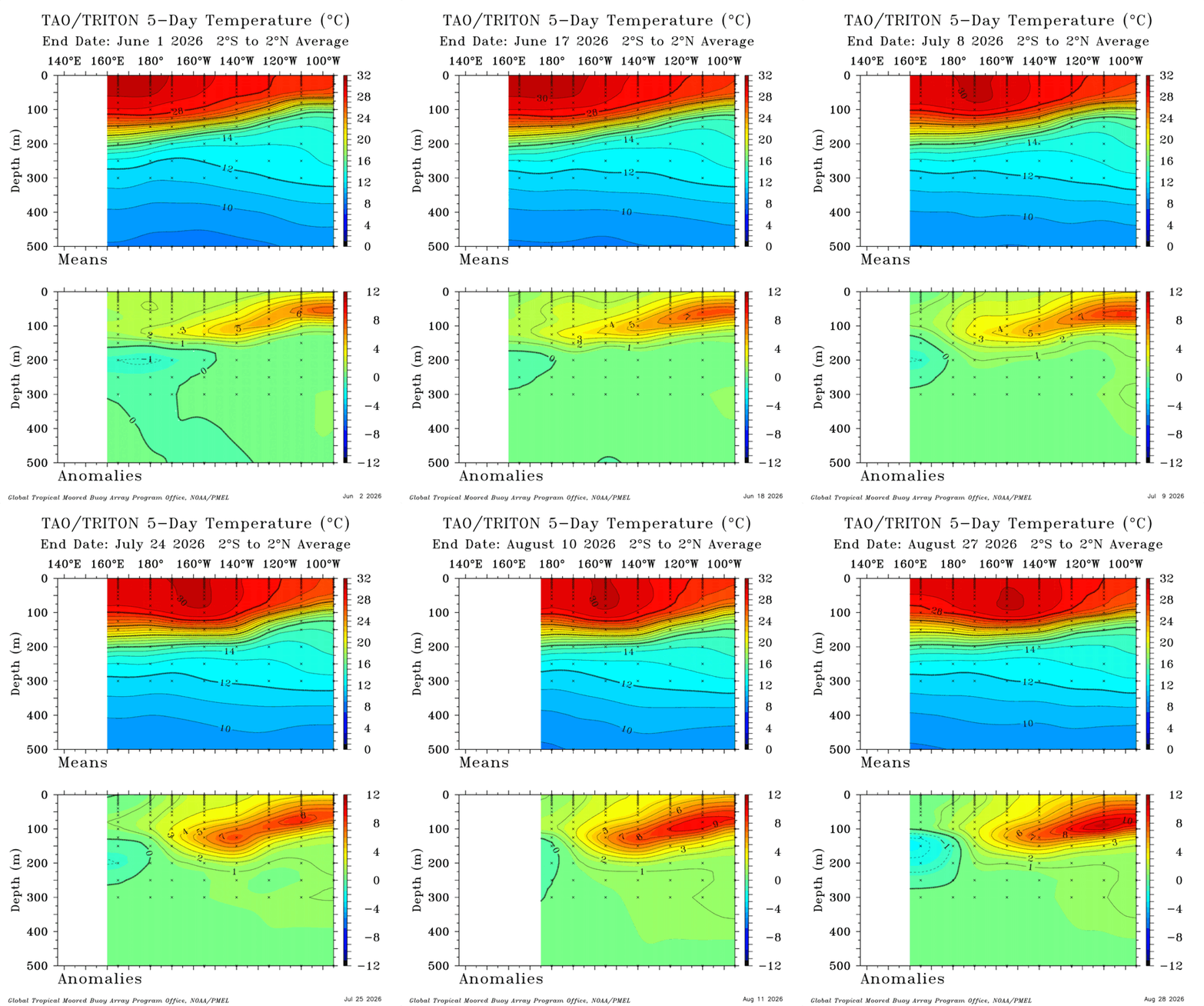
-
Augdewst 2026: Summer's Last Stand
weatherwiz replied to Prismshine Productions's topic in New England
Ultimately, I can see two corridors, one from SW CT into NJ and a second across NY into northwest MA/VT...this area could have potentially greater severe probabilities and tornado threat, especially if that LLJ ramps up a bit earlier than forecast -

Augdewst 2026: Summer's Last Stand
CoastalWx replied to Prismshine Productions's topic in New England
I honestly cannot recall a more boring summer. Been great weather overall, just boring AF. At least locally. -
How much though? 2015 levels of suck or more like 2023?
-
Augdewst 2026: Summer's Last Stand
CoastalWx replied to Prismshine Productions's topic in New England
Congrats NJ to DXR -
-

Augdewst 2026: Summer's Last Stand
Damage In Tolland replied to Prismshine Productions's topic in New England
Congrats DXR southwest -
Augdewst 2026: Summer's Last Stand
Damage In Tolland replied to Prismshine Productions's topic in New England
Really the south coast within about 30 miles ish -

2026-2027 Record-breaking El Nino
mitchnick replied to Stormchaserchuck1's topic in Weather Forecasting and Discussion
My take is that we're .1 or .2 warmer than 1997, some 29 years ago, and despite the warming/warnings, neither the world nor mankind has ended as a result of GW. Enjoy the weekend all. -

Augdewst 2026: Summer's Last Stand
Hailstoned replied to Prismshine Productions's topic in New England
Yer gettin all sequiter about something thrown out there, rather tongue in cheekquiter. This is because there's no reasonable discussion to be had of our now poisoned Well of Ontario. - Today
-
 I was reading about this here: [url=https://www.medguideusa.com/guide/lasix/]Lasix guide[/url]. Highly recommended!
 -
Looks like we are on track to end August with <2 ACE points. Currently sitting at .9 points.
-
Remnants Of Dolly Discussion Number 5 NWS National Hurricane Center Miami FL AL042026 1100 AM AST Fri Aug 28 2026 During the past few hours, the center of Dolly passed just north of NOAA buoy 41041, which did not observe any westerly winds. Examination of high-resolution satellite imagery also does not readily indicate any westerly winds south of the center. Based on this, Dolly has become an open tropical wave, with the initial and forecast positions being that of the vorticity maximum. The initial intensity remains 35 kt, with those winds occurring north of the vorticity center. The system is moving 280/22 kt, and this motion should continue for the next 24 h. After that time, a general westward to west- northwestward motion with a slight decrease in forward speed should take the remnants of Dolly near the Leeward Island Saturday night or Sunday, and near Puerto Rico and the Virgin Islands by Sunday afternoon or Sunday night. A continued west-northwestward motion is expected after that, with the remnants moving through the Greater Antilles or the Bahamas during the early part of next week. The system is currently in a hostile environment with significant southwesterly shear and dry air. These conditions should continue for at least the next 2-3 days, and the remnants should slowly weaken during this time. The official forecast shows 24 h of points where the maximum winds are at tropical-storm force and there is a well-defined vorticity center. After that, the winds are expected to decrease below 35 kt, and the system center is expected to become less well-defined. Some global models hint at the possibility that Dolly could regenerate in several days, but at this time there is poor agreement on where and when this might occur. Should conditions warrant, further information regarding the potential redevelopment of the remnants of Dolly will be provided in subsequent Tropical Weather Outlooks. This is the last advisory on Dolly issued by the National Hurricane Center. Additional information on this system can be found in High Seas Forecasts issued by the National Weather Service, under AWIPS header NFDHSFAT1, WMO header FZNT01 KWBC, and online at ocean.weather.gov/shtml/NFDHSFAT1.php. KEY MESSAGES: 1. Heavy rains from the remnants of Dolly could affect the Leeward Islands late Saturday into Sunday with possible impacts in the Virgin Islands, Puerto Rico, and Hispaniola Sunday and Monday. This heavy rain may produce flash flooding within areas of higher terrain of the Leeward Islands. FORECAST POSITIONS AND MAX WINDS INIT 28/1500Z 15.0N 46.9W 35 KT 40 MPH...POST-TROPICAL 12H 29/0000Z 15.6N 50.3W 35 KT 40 MPH...POST-TROPICAL 24H 29/1200Z 16.4N 54.7W 35 KT 40 MPH...POST-TROPICAL 36H 30/0000Z...DISSIPATED $$ Forecaster Beven
-
Monthly rain: EWR: 10.16 NYC: 8.49 LGA: 7.84 JFK: 7.46 PHL: 7.43 TTN: 7.34
-

Augdewst 2026: Summer's Last Stand
Brian5671 replied to Prismshine Productions's topic in New England
Just post it saying SW CT bullseye and you'll be right. -

Augdewst 2026: Summer's Last Stand
tamarack replied to Prismshine Productions's topic in New England
Of course, though we got all of 0.03" last evening, along with a near miss TS that terrorized our dog. We've had 5 rain events in the past 2 weeks for a grand total of 0.18". drip, drip, drip