All Activity
- Past hour
-
Holy 6z Euro…. .
-

Possible coastal storm centered on Feb 1 2026.
The 4 Seasons replied to Typhoon Tip's topic in New England
You are playing the semantics game, you asked me what my forecast is right now, i told you. Of course theres a chance, theres always a chance even after 12Z tomorrow. Crazier things have happened in very close range. I'm always the first one to say that, its never 100% done. It's just extremely low right now. For far SE MA id still be interested, but thats about it. That's where i stand -

The “I bring the mojo” Jan 30-Feb 1 potential winter storm
lilj4425 replied to lilj4425's topic in Southeastern States
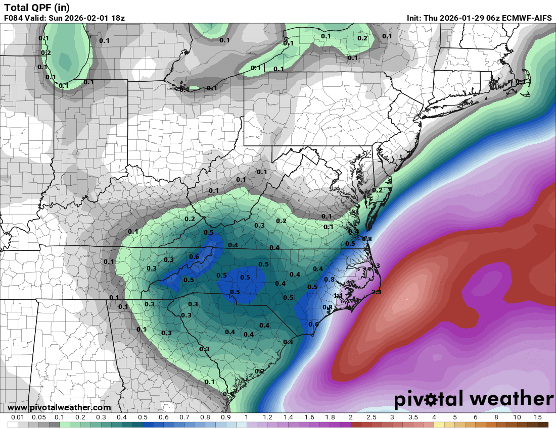
Shows the entire western Carolinas getting over a foot. lol. -

The Jan 31 Potential: Stormtracker Failure or 'Tracker Trouncing
DDweatherman replied to stormtracker's topic in Mid Atlantic
Absolutely does, except his map this time isn’t even the euro lol. Wish he was right…but he’s not -
Here is my first call map. Might have to up it especially west of Asheville if the Euro keeps firing. Looking to see what the NAM 3km has for us today it seems to be built for systems like this.
-

The “I bring the mojo” Jan 30-Feb 1 potential winter storm
ADB83 replied to lilj4425's topic in Southeastern States
I saw some local meteorologists start saying this yesterday evening and it looks like they were picking up on something. A lot of dry air and there are gonna be some dry slots to deal with that will set up somewhere. It’s never easy here. . -

The “I bring the mojo” Jan 30-Feb 1 potential winter storm
franklin NCwx replied to lilj4425's topic in Southeastern States
I can't see the 6z. The upper low most likely we negative tilt quicker that the 0z run. That would result it more qpf on the NW side of the upper low -

Possible coastal storm centered on Feb 1 2026.
ORH_wxman replied to Typhoon Tip's topic in New England
Slightly worse than 00z. You are still in the game but the rest of us are prob done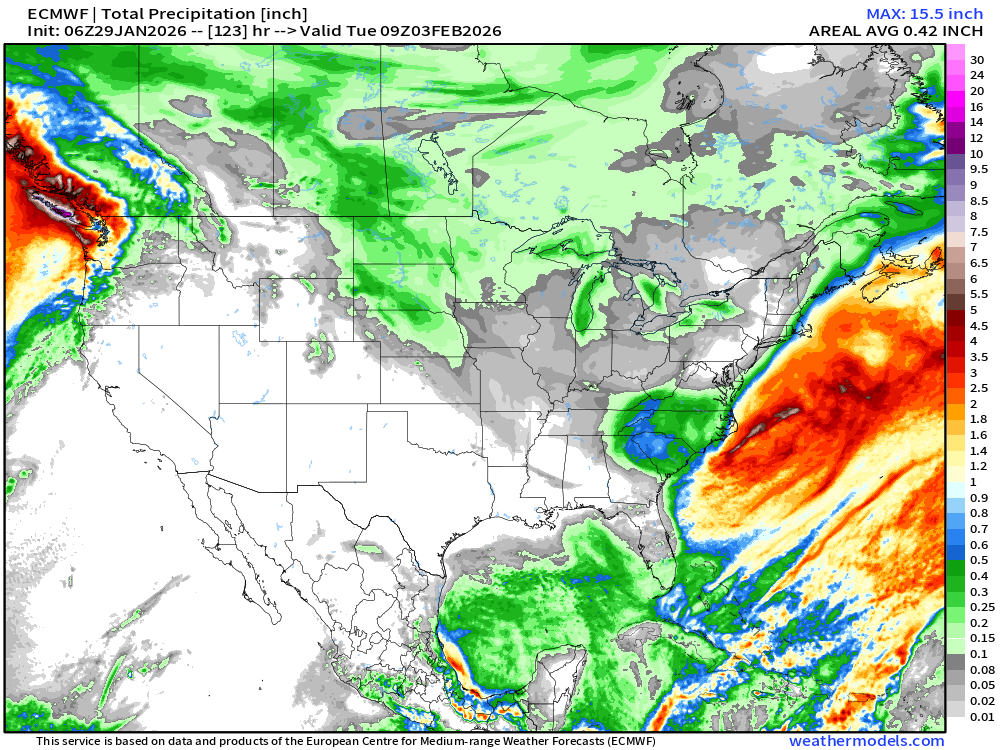
-
Great EURO run for the board .
- 236 replies
-
- 1
-

-
- extreme cold
- snow
- (and 1 more)
-

Possible coastal storm centered on Feb 1 2026.
ChangeofSeasonsWX replied to Typhoon Tip's topic in New England
Yeah I mean, considering some of the S Tier analogs that were on the table several days ago its definitely disappointing that we could be looking at a whiff. I mean even scoring a few inches would be nice. Just goes to show how unreliable those early models are. Hopefully we can get some positive last minute trends. -
Just realized I never posted here. We measured 19 inches in Simsbury and 18 in Westfield. I've seen a couple reports of 21 inches in Simsbury... Maybe the west side of town
-

Possible coastal storm centered on Feb 1 2026.
Ginx snewx replied to Typhoon Tip's topic in New England
Scooter quit eh. Ĥmmm.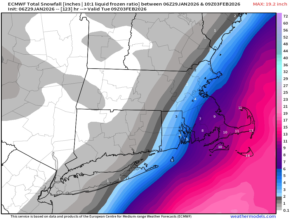
-
Euro AI looks good for some small/moderate events after the 6th
-

Richmond Metro/Hampton Roads Area Discussion
wasnow215 replied to RIC Airport's topic in Mid Atlantic
? Any maps yet? -

The “I bring the mojo” Jan 30-Feb 1 potential winter storm
timnc910 replied to lilj4425's topic in Southeastern States
I am not sure the track record of the AI Euro but it doesn't agree
-
6Z EURO is all upper low
-
Our last true KU coastal snowstorm pattern was February, 2021. For whatever reason, it completely disappeared at the end of that month, never to be heard from again….
-
So basically Bernie Rayno was right.
-
.
-

Possible coastal storm centered on Feb 1 2026.
powderfreak replied to Typhoon Tip's topic in New England
Is that really *that* big of an error margin at that lead time though? Has huge impacts for an area of population but it’s like 50 miles between BOS and ORH… is getting like 50-100 mile swings on 126 to 150 hour total maps all that surprising? Its frustrating but seems within reason… -
2025-2026 Fall/Winter Mountain Thread
franklin NCwx replied to Buckethead's topic in Southeastern States
That was the best run yet for the western areas! -
Wind flow will be very important as we move through Friday for our foothill/lee side areas. Need the best trajectory to max snow. I.e, hope to minimize any down sloping winds or just minimal as the ULL pivots.
-

The “I bring the mojo” Jan 30-Feb 1 potential winter storm
gman replied to lilj4425's topic in Southeastern States
Yes! -

The “I bring the mojo” Jan 30-Feb 1 potential winter storm
BornAgain13 replied to lilj4425's topic in Southeastern States
The system itself looks like its getting locked into a close place as far as where the snow print will be. Now its a matter of how much qpf in your areas. -
The “I bring the mojo” Jan 30-Feb 1 potential winter storm
lilj4425 replied to lilj4425's topic in Southeastern States
Wow. Didn’t see that coming for my area. Why did the qpf shift so far west?