All Activity
- Past hour
-
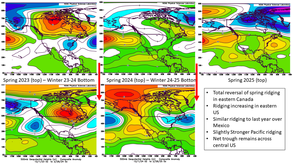
I always like to look at the spring pattern for a hint of how the next winter may evolve. Sometimes there can be some low frequency hints even further back. It's never in exactly the same spot, but if you look at the spring pattern the coming winter pattern often has a similar look, just shifted and amplified or deamplified. Spring 23 offered excellent hints about the winter of 23-24. Last winter wasn't quite as strong of a connection, but there were still hints of the east coast trough pattern as well as the ridging southwest of Greenland. For this year we've seen some interesting changes compared to both the last two years. It appears the low frequency forcing for ridging southwest of Greenland was finally gone this year, which would be a change if that rolls forward into the winter. On the other hand the spring trough moved west with more ridging along the east coast than last year. Theoretically that could mean troughs wanting to dump further west this year if it holds. The Pacific is unchanged so probably some good AK ridging pops up again. Maybe this isn't the most robust method out there, but I've found it has some utility.
-
 What did 6z show?
 -
A wet, ocean spray day at Dewey today. Forecast of sun from earlier in the week sadly incorrect in this summer of clouds and rain. Surf zone with 3 to 4 foot waves, Thursday is the day for peak surf.
-

2025 Lawns & Gardens Thread. Making Lawns Great Again
SJonesWX replied to Damage In Tolland's topic in New England
unless you have irrigation, you might want to hold off on the seeding. -

2025-2026 ENSO
PhiEaglesfan712 replied to 40/70 Benchmark's topic in Weather Forecasting and Discussion
16-17 doesn't really belong on this list. Sure, it technically made 30 inches of snow in NYC (and much of that was due to a mid-March snowstorm), but as you went more south, it was a terrible winter. PHL only got 15 inches of snow, and places like Baltimore and DC only got 3 inches of snow, and had a Top 10 least snowy winter. Plus, all the other winters were near normal temperature (17-18 and 20-21), or well below average. 16-17 was a blow torch. 16-17 is one winter that had a very sharp cutoff, even more so than 07-08. -

Hurricane Erin: 110 MPH - 958 mb - NW @ 7
NorthHillsWx replied to BarryStantonGBP's topic in Tropical Headquarters
Also- pressure up to 960 -
verifying imby
-
Hurricane Erin: 110 MPH - 958 mb - NW @ 7
NorthHillsWx replied to BarryStantonGBP's topic in Tropical Headquarters
Recon had max FL winds of only around 85 kts we will see what this pass shows but man this thing is on life support as a cat 2 at the moment -
We analplasmosis.
-

Hurricane Erin: 110 MPH - 958 mb - NW @ 7
jconsor replied to BarryStantonGBP's topic in Tropical Headquarters
Hurricane Erin, despite weakening significantly in the past 24 hours, may have one more round of strengthening in its arsenal. With a fetch of tropical storm force winds extending out hundreds of miles into the ocean piling up water over three days of high tide cycles, water levels from NC to SE Virginia could rival levels during Dorian and Irene. The Delmarva Peninsula to southern NJ could see a top 5 water level on record as well. https://hurricanehacker.substack.com/p/too-close-for-comfort -
fortunate the heaviest bullseyes ended up rural and over the lake, shift that bullseye over the lake a bit nw and it would have been trouble for sure
-

Hurricane Erin: 110 MPH - 958 mb - NW @ 7
TimB replied to BarryStantonGBP's topic in Tropical Headquarters
Yes, you can track your fellow long islander’s surfing adventures at usersesh. https://discord.gg/umSDREbM -
More drought brings earlier autumn leaf fall, Northern Hemisphere study finds
-
Really nice morning! Some heat later this eek (nothing bad) and then over the weekend and next week some fall feelings coming.
-
Alright maybe not over, but not sure much happens with Ferdy or whatver the name is.
-
This is the best hurricane tracking map to use...
-
0.12" yesterday and overnight from showers and drizzle. 1.35" the last couple days including the Sunday night storm.
-
Crazy we're only a few weeks away from the start of the NFL regular season and about a month away from pre-season hockey. Where did my summer go
-
Nina in and of itself isn’t unfavorable for NYC, it’s more of a killer south of the M/D line though last winter was very good snow-wise even in the Deep South when the pattern deamplified. But NYC is in a particular Goldilocks geographic area where there isn’t a defined storm type that can be relied on to produce-we’ve had huge Miller B and more suppressed Miller A, and can if we’re lucky get 3-6” from a SWFE, just about all types other than cutter can produce for NYC but also be a dud. The fast Pacific along with the Nina arranged the pattern in such a way that it caused dud after dud despite cold enough air in place multiple times.
-
49 this morning. Nice! 50's and rain sounds good for tomorrow. Hoping for a ton of rain. Maybe get some early Maitake (hen of the woods) growing.
-
Yikes. I don’t feel this shot down since I asked Julie Adam’s to the prom
-
Hurricane Erin: 110 MPH - 958 mb - NW @ 7
NorthHillsWx replied to BarryStantonGBP's topic in Tropical Headquarters
I’ve gotta say I did not expect the system to get sheared apart to this degree. It looks like about 15-20kts of analyzed shear which certainly would be an inhibiting factor but shouldn’t be shredding it to the point that half the circulation is now exposed. There is no way this system is still a major and unless that shear relaxes it will continue to weaken because it does not look healthy at all. EDIT: I missed the 8 am where it was brought down to cat 2. 95 kts still seems generous based on satellite id wager it is closer to 85 kts at this time given 1/2 of the eye is now exposed -
It’s not rotten luck. The Pacific Jet oriented in a way and strength that systematically destroyed our chances especially south of I-90 to PHL. Historically when it’s been cold enough in NYC it’s found a way to snow because there would be a PNA ridge that would stick around long enough or NAO blocking to slow the pattern down. Now the Pacific Jet knocks it all down like bowling pins and storms either can’t amplify in time or amplify too much.
-

Hurricane Erin: 110 MPH - 958 mb - NW @ 7
BarryStantonGBP replied to BarryStantonGBP's topic in Tropical Headquarters
path looks familiar https://www.tropicaltidbits.com/storminfo/05L_geps_latest.png -
Cane season over.


