All Activity
- Past hour
-
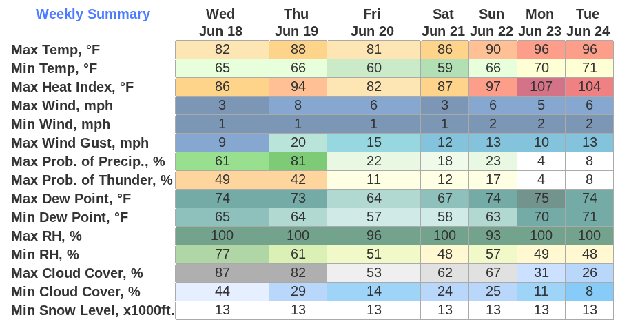
At present, I suspect that the most plausible outcome is lower to middle 90s in NYC and upper 90s/near 100 in the hot spots in NJ. Some onshore flow will probably keep the truly extreme heat at bay.
-
Erick is rapidly intensifying this morning and looks to be near major hurricane strength at landfall. Josh is chasing too. Crazy amount of RI into landfall storms recently in EPAC. This one looks mean on sat already this morning if trends continue this could be a significant impact
-
Another banner day around the commonwealth. Low clouds and showers. long live summer
-
This is your typical 88-93 for home stations and Bdl will throw out a 96-98 day on the tarmac
-
# No heat wave in Tolland
-
Sunday- Wednesday is 90’s to near hundred Tuesday . 4 days
-
Agreed. I'm skeptical of us hitting 100° during this stretch.
-
The heat index predicted for Sun - Tues are very dangerous. Take care of yourselves those days everyone.
-
SSW wind now pushing humidity - Dewpoint 69 here More thinning of the clouds and up to 73
-
You don’t say.
-
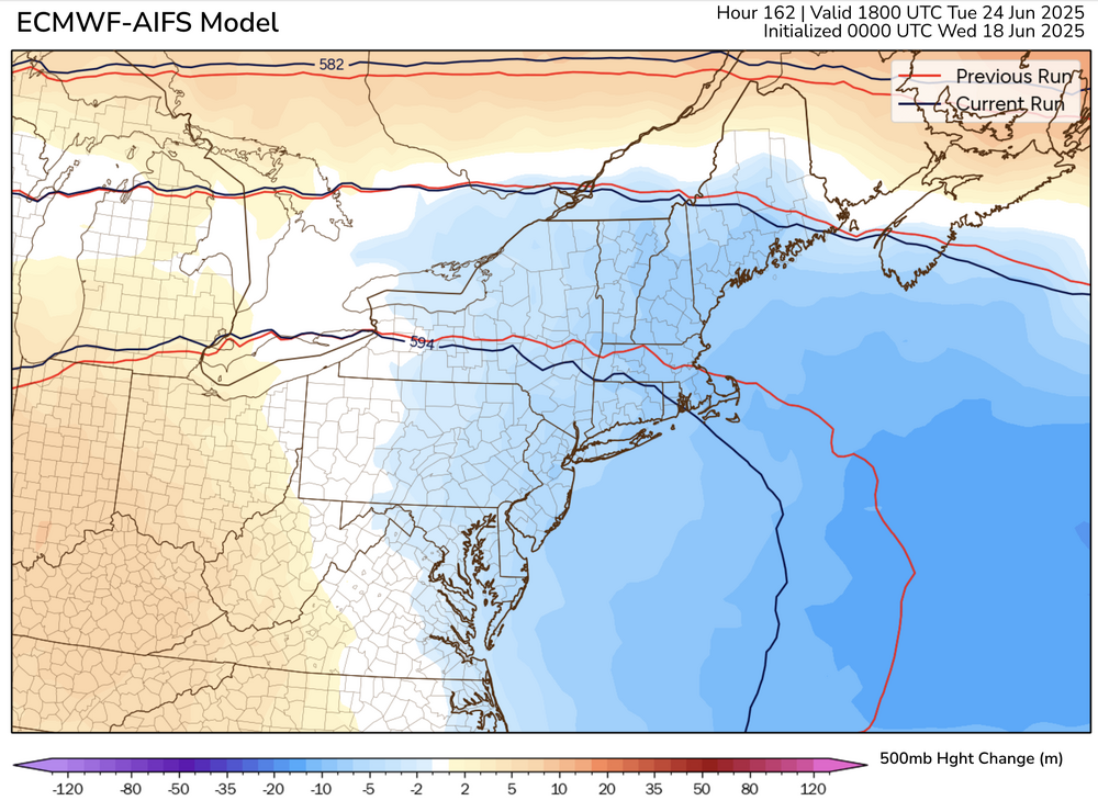
The Euro and AI version are trending down slightly with max heights on Monday and Tuesday. Here is an example for the AI Euro for Monday:
-
Yeah so others are onto it ... no heat wave next week. Pattern is sputtering to 2 days on, 2 days off... and no confidence there after for next weekend. The 2 days off could end up being dramatic too... We've gone from 101's in guidance to 68s over eastern NE.. The problem is up over eastern Canada. From what I can tell, whether or not heat can expand and amplify for something more than merely pedestrian AN is sensitive to what is happening up there. The flow has been sneakily correcting deeper and deeper with that anachronistic SPV SW of the D-Straight... The Euro at this point has a strong polar jet now curving around underneath - heat in New England seldom succeeds with polar jets in that position. The idea of a +PP emerging and crushing the fragile heat S is really academic at this point. The only way to reverse all that is to have that SPV substantially weaken in the guidance. So, this may have been just another extended red herring ... no harm no foul. We've spoken about the confidence risks already. Plenty of time and this is all acceptable adjusting at this range. I will say, the ensemble means are still flatter with the flow up there, however - so ...it's not impossible that the operational versions are a bit too amplified with that circulation structuring up there. We'll have to see.
-
First mention of “we don’t get night thunderstorms anymore” this year?
-
I know that it often depends on wind direction/humidity but when looking at the models, what is the 850 MB general criteria (for our region) to support 100 degrees? I had always believed that 850mb temp of 15c would support 90F and 850mb >20c would support 100° F?
-
3 thunderstorms last night, the last one at 2:30 am with heavy rain and super intense lightning, too. i’ll have to check the rain total but it’s been a wet few days out here—good.
-
Yeah the lighting last night was absolutely amazing. That was the most charged storm that I can recall in past couple of years. Lots of close strikes downtown here.
-
Early summer doing what it dews
-
they'll do that
-
Records: Highs: EWR: 97 (1993) NYC: 95 (1929) LGA: 95 (1994) JFK: 94 (1962) Lows: EWR: 49 (1950) NYC: 48 (1950) LGA: 49 (1950) JFK: 53 (1959) Historical: 1875 - A severe coastal storm (or possible hurricane) struck the Atlantic coast from Cape Cod to Nova Scotia. Eastport ME reported wind gusts to 57 mph. (David Ludlum) 1958 - Hailstones up to four inches in diameter killed livestock as a storm passed from Joliet to Belfry in Carbon County MT. (The Weather Channel) 1970 - Wind and rain, and hail up to seven inches deep, caused more than five million dollars damage at Oberlin KS. (The Weather Channel) 1972: Hurricane Agnes was one of the most massive June hurricanes on record. The system strengthened into a tropical storm during the night of the 15th and a hurricane on the 18th as it moved northward in the Gulf of Mexico. 1987 - It was a hot day in the Upper Great Lakes Region. Nine cities in Michigan and Wisconsin reported record high temperatures for the date. The high of 90 degrees at Marquette, MI, marked their third straight day of record heat. Severe thunderstorm in the Northern and Central High Plains Region spawned half a dozen tornadoes in Wyoming and Colorado. Wheatridge, CO, was deluged with 2.5 inches of rain in one hour. (The National Weather Summary) (Storm Data) 1988 - Severe thunderstorms in eastern North Dakota and northern Minnesota produced hail three inches in diameter and spawned four tornadoes in Steele County. Thunderstorms also produced wind gusts to 80 mph at Clearbrook MN. (The National Weather Summary) (Storm Data) 1989 - Unseasonably hot weather prevailed in the southwestern U.S. In Arizona, afternoon highs of 103 degrees at Winslow, 113 degrees at Tucson, and 115 degrees at Phoenix were records for the date. (The National Weather Summary) 1991: Atlanta, GA recorded a new record for the amount of rainfall in one hour as 3.47 inches fell between 6:52 pm and 7:52 pm EDT. (Ref. Wilson Wx. History) 1993: In west central Kansas, heavy rain caused roads in the Syracuse area to flood. As much as one foot of water covered some roads for a short period of time. In Greeley County, golf ball size hail, driven by thunderstorm winds, damaged wheat and broke windows along a four mile path from five miles south of Astor to nine miles south of Astor. (Ref. Wilson Wx. History) 1997: Over 6 inches of rain fell at Columbia, MS in a three hour period and 8.25 inches fell in a 24 hour period. Water entered thirty businesses in Columbia, with 12 of the businesses suffering major damage. Eight homes also suffered flood damage. Many roads were washed out and had to be closed. Numerous cars were under water. This event caused $15 million dollars in property damages. Several roads were also flooded across the south half of Forrest County. (Ref. Wilson Wx. History) 1999: Record morning chill occurred across the Appalachians. Record lows for the date included: , Elkins, WV: 39 °F, Pittsburgh, PA: 43 °F, Bluefield, WV: 46 °F. (Ref. Wilson Wx. History)
-
Way too early in the day for me to think. Congrats you!
-
Not fun!
-
Lack of sunshine also leads to other issues such as mildews, various plant and lawn fungus, garden issues, plant blights, etc., and seasonal depression issues for some. Its so old now, I rather have sun and a heat versus a swamp and no sun for weeks. Far less sun versus clouds the last 90 days.
-
This is gonna suck, isn’t it? I don’t think I’ve ever seen a temp/DP combo quite like 96/75

-
I haven't had a chance to review all the posts last 4 hours, but from my vantage point. THREE 100 deg days in June is still a possibility INLAND NJ-NYS/CT, BUT, same caveats as yesterday... pattern isobars show quite a bit of weakness so its easier to Seabreeze early in the season, plus T STORM cloud cover debris is unknown. (not sure how EC spreads 100 so far inland across LI/NYC next week and so I have to expect some tempering of those excessive projections in the weekend updates). I think 00z/18 GFS MEX MOS is wayyy too cool on daytimes for KEWR but its something to keep in mind. Thursday max at KEWR is my decision break point on any 100 degree thread for next week that would possibly issue Thursday evening. I've no plans to thread tomorrows fairly widespread severe wind potential along I95. Am pretty sure we'll see a a nw flow MCS - iso severe in NY metro early Sunday morning as the warm front returns. My KEWR 90 degree days are Thu, possibly both Sat/Sun, certainly Mon-Wed and then maybe again Thu and Sat of next week with 3 100's possibly??? embedded between Mon-Sat of next week. SVR potential in slow moving deluges wherever sea breezes intersect next Mon-Tue (if not capped). Noticed besides the 2-4K J ML Cape early next week- there are rather large 7H-5H lapse rates. IF something goes, would be microburst w hail/wind/ flooding...thats IFFFF.
-

2025 summer max contest -- enter by 06z June 20
gopper replied to Roger Smith's topic in Mid Atlantic
DCA: 103 IAD: 102 BWI: 102 RIC: 102